Cyclone Kyant |
Cyclone Kyant Path
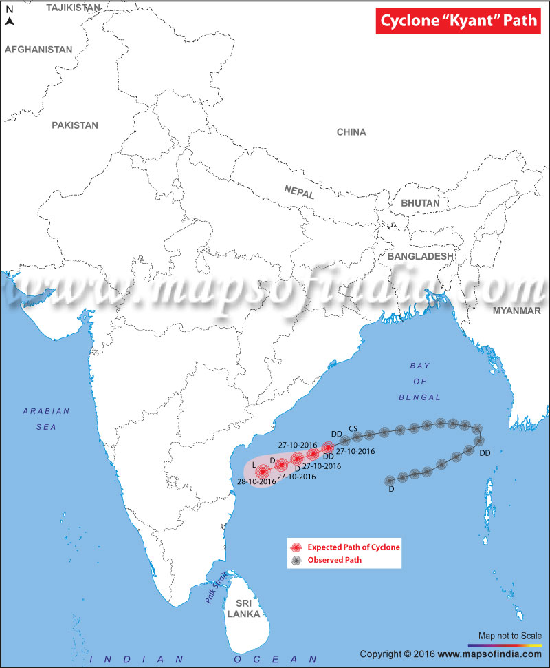
Map showing the Cyclone Kyant expected and observed path
Cyclone Kyant: Deep Depression over westcentral Bay of Bengal
Forecast track and intensity of the system:
| Date/time(IST) | Position (lat. °N/ long. °E) | Maximum sustained surface wind speed (kmph) | Category of cyclonic Disturbance |
|---|---|---|---|
| 27-10-2016/0530 | 15.7/85.5 | 50-60 gusting to 70 | Deep Depression |
| 27-10-2016/1130 | 15.3/84.6 | 50-60 gusting to 70 | Deep Depression |
| 27-10-2016/1730 | 15.0/83.8 | 45-55 gusting to 65 | Depression |
| 27-10-2016/2330 | 14.7/83.0 | 35-45 gusting to 55 | Depression |
| 28-10-2016/0530 | 14.4/82.0 | 25-35 gusting to 45 | Low |
Why is the Cyclone called Kyant?
The new cyclone in Myanmar has already caused flooding in some areas. The latest report says that it is now heading towards the east coast of India and might reach areas of West Bengal and Odisha. Neighbouring country Bangladesh also may experience some rainfall.
Apart from the torrential rainfall that the cyclone may bring by the end of the week, people are curious to know the reason behind naming the cyclone Kyant. The cyclone got its name Kyant in Myanmar, which means Crocodile in Mon language, spoken by Mon people of Myanmar and Thailand.
The concept of naming cyclones was started years ago as it has always been found easier to remember such calamities by name. The naming system was varied. Usually, the names are given to the storms which are familiar to the regions. However, there is a systematic procedure to name any cyclone and it is taken care by an international committee of the World Meteorological Organisation.
Eight northern Indian ocean countries including Bangladesh, India, the Maldives, Myanmar, Oman, Pakistan, Sri Lanka and Thailand have brought up a list of 64 names so far. They take turns when it comes to name the cyclones and usually name the ones which are formed in Arabian Sea and the Bay of Bengal. The names of the cyclones are usually easy to remember and not sensitive to any culture.
The latest update says, IMD has issued cyclone warning over Bay of Bengal.
Read : What are Cyclones: Types, Causes and Effects
Cyclone Kyant: News and Updates
Cyclone Kyant Weakens But Rains May Lash Andhra Pradesh
4:30 PM, Thursday, 27 October 2016
Cyclone Kyant has weakened and by Thursday it is expected to lose all its strength. However, experts still say that the South Coastal Andhra Pradesh may witness some light to moderate rains and thundershowers on October 28. The coastal areas also may experience some squally winds with speed up to 40-50 kmph. Some other areas in Andhra Pradesh and Telangana may also face some on and off rains till October 30. By October 31, the rain activity is expected to disappear.
Cyclone Kyant Slows Down its Pace
11:02 AM, Thursday, 27 October 2016
According to reports from India Meteorological Department (IMD), cyclone Kyant is moving at speed of 17 kmph and in past 6 hours it has moved further west-southwestwards. The cyclone is unlikely to make a landfall, but the coastal regions of states like Odisha, Andhra Pradesh and Tamil Nadu may experience a wet Diwali. The Cyclone Warning Division of IMD says that by October 29, the cyclone may fade into a deep depression.
Cyclone Kyant Heading to Andhra Pradesh
6.10 PM, Wednesday, 26 October 2016
As per media reports, Andhra Pradesh will soon get hit by cyclone Kyant which is moving towards the coast of the state with speed of 18 kmph. It is presently at a distance of 450 km southeast of Gopalpur, 520 km east-southeast of Vishakhapatnam and 730 km east-northeast of Machilipatnam. Though Odisha will not be affected by the cyclonic storm, but the condition of the sea is still very rough. Fishermen have been advised not to venture into the sea.
Light to moderate rainfall may occur in the south Odisha & north coastal Andhra Pradesh on Thursday and Friday.
Cyclone Kyant Nears Andhra Pradesh
12.45 PM, Wednesday, 26 October 2016
The latest reports say that cyclone Kyant is getting closer to Andhra Pardesh, thus the state is on alert now. Reports have also confirmed that the cyclone will spare Odisha. As per Skymet Weather, landfall may take place in the coast of Andhra Pradesh, in between Ongole and Nellore.
The speed of the winds is expected to be 45-55 kmph and gusts up to 65 kmph.
The places that will be on high alert are Visakhapatnam, Srikakulam, Puri, Gajapati, Ganjam, Gopalpur, and East Godavari.
Cyclone Kyant May Weaken Before Reaching Andhra Pradesh and Tamil Nadu
10.20 AM, Wednesday, 26 October 2016
As per the report from Indian Meteorological Department (IMD) , the cyclonic storm Kyant may lose its strength before it touches Andhra Pradesh and Tamil Nadu. However, the weather condition may get unfavourable.
Dr KJ Ramesh, IMD director-general of meteorology from New Delhi said, “The sea surface temperature was favourable to the system on Tuesday when it was moving over the middle. However, the temperature may not be favourable for the storm when it comes close to the coast towards AP or Tamil Nadu. This may be the main factor for weakening of the system before reaching the coast in next three to four days.”
A clear picture is expected to get on Thursday.
Odisha Won’t be Affected by Cyclone Kyant, Says State Government
6.15 PM, Tuesday, 25 October 2016
As reports from sources, the Odisha government has said that the cyclone Kyant will not leave any impact on the state. As mentioned by Special Relief Commissioner (SRC) Pradipta Kumar Mohapatra, “The cyclone which was heading towards Myanmar has re-curved and is moving towards south-west. It is not touching Odisha. It is likely to touch Andhra Pradesh. But, rains will occur in coastal belt of the state as an impact of the passing cyclone.”
He further stated that 14 district collectors have been advised to make sure that the harvested crops are stored properly as a precaution. The leaves of officials have been cancelled by the government so that they remain alert.
Cyclone Kyant May Cause Torrential Rainfall in India Later this Week
2.45 PM, Tuesday, 25 October 2016
Cyclone Kyant is strengthening, and predictions say that it may result in heavy torrential rainfall in India by later this week. The depression in the Bay of Bengal has strengthened into a cyclone on Tuesday afternoon and is moving from areas of western Myanmar to eastern India.
With rainfall of 2 inches, the impact of this cyclone will be limited to western Myanmar. However, conditions in the Bay of Bengal will be worse as the boats in the area may face strong winds. The newly formed storm will move toward eastern India causing rainfall in Kolkata and southern Bangladesh and southward to Srikakulam on Wednesday. As predicted by the weather experts, with gusts over 80 km/h (50 mph) Thursday night will see the worst condition in areas like Puri and Kakinada.
Areas where flooding are expected include Visakhapatnam, Srikakulam, Puri and Balasore.
East Coast Under Cyclone Kyant Threat
According to IMD sources, a cyclonic storm Kyant is forming in the Bay of Bengal which may bring heavy rains in the East Coast of India. Fishermen have been asked to be cautious while venturing into the sea as the condition in the water bodies may not remain stable.
Some predictions by weathermen suggest that the cyclone can make landfall in northern Odisha and a few parts of West Bengal. The chief of Cyclone Warning Centre, New Delhi, Mrutunjay Mohapatra said that the cyclonic storm has re-curved from Myanmar Coast, moving towards India Coast and may turn into a cyclone.
However, people have been asked not to panic by the Odisha government as the cyclone may not leave devastating effect. A meeting on the preparedness for the possible cyclonic storm is going to be called by Chief Minister Naveen Patnaik.
View All Hurricanes and Tropical Cyclones:
Cyclone Hudhud
Cyclone Roanu
Cyclone Komen
Cyclone Ashobaa
Cyclone Nilofar
Cyclone Phailin
Cyclone Prone Areas in India
SMS-Based Cyclone Warning System Launched in India