
List of Taluk in Dhubri District | ||
|---|---|---|
| Taluk Name | Total (Rural + Urban) Population (2001) in Number | Pin Code |
| Agamoni | 141,703 | N.A |
| Bagribari (Pt) | 160,764 | 783349 |
| Bilasipara (Pt) | 212,769 | 783348 |
| Chapar (Pt) | 128,076 | 783371 |
| Dhubri (Pt) | 368,285 | 783301 |
| Golokganj (Pt) | 186,923 | 783334 |
| Gossaigaon (Pt) | N.A | N.A |
| Mankachar | 238,901 | 783131 |
| South Salmara | 199,923 | 783127 |
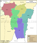
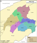
Dhubri Tehsil Map |
|
|||||||||

| |||||||||
|
| *Map highlights the name and location of all the tehsils in Dhubri district, Assam. | Disclaimer |
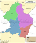
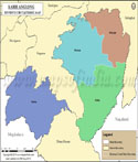
| Major Tehsils of Assam |
 |
 |
 |
 |
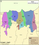
| Cachar Tehsil Map | Baksa Tehsil Map | Barpeta Tehsil Map | Dhemaji Tehsil Map |
 |
 |
 |
 |
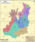
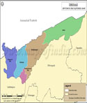
| Dibrugarh Tehsil Map | Dima Hasao Tehsil Map | Kamrup Metropolitan Tehsil Map | Karbi Anglong Tehsil Map |
| more tehsils of Assam >> |
Last Updated on : August 26, 2015
|
|