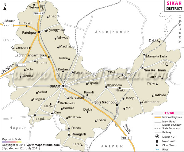
The town of Sikar is the administrative center of the district. Sikar District Map would help the travelers during their trip to the place.
Population
According to the report of 2001 India census, Sikar district has a population of around 2,287,229.
Economy
The economy of the district is primarily based on agriculture. The chief crops produced in Sikar are bajra (pearl millet) and gram (chickpea). The minerals mainly found in the district are copper and iron-ore.
How to Reach
Transportation in Sikar is well-developed. The nearest airport is at Jaipur, at a distance of 116 kilometers. Sikar is also well-connected by rail with the major cities and towns such as Jaipur, Delhi, Ganganagar, Bikaner and Churu.
Sikar district is also accessible by an extensive network of road.
Tourist Destinations
Travelers in Sikar can go to visit the following destinations:
-
Ganeshware: Ganeshwar, at a distance of only 15 kilometers from Neem ka Thana, is an eminent holy site as well as popular picnic spot.
-
Harshnath: Harshnath Temple is located only 14 kilometers from Sikar.
-
Jeenmata: The place is famous for the ancient temple dedicated to Jeen Mata (Goddess of Power).
- Khatu Shyamji: Situated at distance of 65 kilometers from Sikar, the charming village is famous for Shyamji Temple.
| Facts of Sikar District | |
|---|---|
| State | Rajasthan |
| District | Sikar |
| District HQ | Sikar |
| Population (2011) | 2,677,333 |
| Growth | 17.03% |
| Sex Ratio | 947 |
| Literacy | 71.91 |
| Area (km2) | 7732 |
| Density (/km2) | 346 |
| Tehsils | Danta Ramgarh, Fatehpur, Lachhmangarh, Neem Ka Thana, Sikar, Sri Madhopur |
| Lok Sabha Constituencies | Sikar, Jhunjhunu |
| Assembly Constituencies | Dantaramgarh, Dhod, Fatehpur, Khandela, Lachmangarh, Neem Ka Thana, Sikar, Srimadhopur |
| Languages | Hindi, Rajasthani including Shekhawati |
| Rivers | ----- |
| Lat-Long | 27.581329,75.057793 |
| Travel Destinations | Gopinath Temple, Rathore ji ka Raghunath Temple, Chhoti Lal Sagarmal Sodhani Haveli, Digamber Jain temple, Raghunath Temple, Bawri (Stepwell), Devi Singh Cenotaph, Laxman Singh Cenotaph, Maji Sa ka well, Laxmangarh Fort, Ram Lal Murlidhar Ganeriwala's, Sanwat Ram Chokhani Haveli, Shiv Naraian Mirja Mal Kyala Haveli, Bal Mukund Bansidhar Rathi Haveli, Ram Vilas Sanganeria Haveli, Keshardeo Sarraf Haveli, Multan Chand Kedia Haveli, Nawabi Bawri, Gharwa Johra, Jagan Nath Singhania Haveli, Nand Lal Devra Haveli, Ram Gopal Poddar Cenotaph, Shani Dev Temple, Ganga Temple, Baij Nath Ruhia Haveli, Khatushyamji Temple etc. |
| Government Colleges/Universities | Government Law College (Sikar), Govt. Girls College (Hod), Govt. Girls College (Sikar), K.M. Government Girls College (Neem Ka Thana), R.N.R. Government College (Ramgarh Shekhawati), S.K. Government P.G. College (Sikar), S.N.K.P. Government College (Neem Ka Thana) etc. |
Last Updated on : February 19, 2026
