
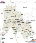
Introduction
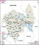
The Pauri Garhwal region which was sometimes known as part of the Garhwal district in earlier days within the administration history is a crucial and culturally diverse district of the Indian state of Uttarakhand. Pauri Garhwal to be in the western Himalayas and is a zone of breath-taking landscapes, holy river system and the strongly spiritual practices. Pauri Garhwal began to be called that because of the name of a town called Pauri that is the administrative headquarters and that of the history of the continuation of the Garhwal identity in this part of the region. The map of the district has been an invaluable source of information about geography of this mountainous area and patterns of settlements.
The district map of Pauri Garhwal reveals geographical diversities which are mid Himalayan hills with forest covered slopes and river valleys in some parts of south and also the foothill plain. Here, it is on this terrain that flow rivers such as Nayar and Ganga river system which are important both in means of livelihood as well as religious significance. Pauri Garhwal district map helps in finding out the local route of travel, pilgrimage and settlements that is important to know the region.
The Pauri Garhwal district map also helps in understanding the location of Pauri Garhwal district with districts of Garhwal surrounding and the plains of Uttar Pradesh towards the south. It is because of this that Pauri Garhwal is in the past related to both the mountainous culture and the plains economy.
Nowadays, the Pauri Garhwal district map is not only the cartographic image but also the image of the identity, heritage, and continuity. The area is also commonly referred to as part of Dev Bhoomi, or, the Land of the Gods due to its presence of many temples and holy places. The Pauri Garhwal district map still has its way to direct travellers, researchers, and pilgrims on their way to this Himalayan landscape.
History
Pauri Garhwal has a rich and complicated history that incorporates the myths of Garhwal with the history of political events covered by documents. The region of Garhwal including Pauri area is called Kedarkhand in the early Hindu literature like the Mahabharata and the Skanda Purana, a holy land belonging to Lord Shiva. According to these excerpts, the region has been traditionally regarded as a spiritually evocative region, with sages, pilgrims and seekers flocking the region since antiquity.
The interpretation of Pauri Garhwal district map can show that, originally, the region had been calmly inhabited by the indigenous populations such as Kols, Kiratas and Khasas. These groups were in turn succeeded by larger political groups including the Kuninda and in its turn the Katyuri dynasty who had a major influence in the early political and cultural life of the land.
One of the most significant moments in the Garhwal history came in 14th or 15th century when King Ajai Pal consolidated the number of small principalities which was traditionally deemed as fifty two forts into a single kingdom. The area of present Pauri Garhwal was part of this unified Garhwal kingdom and played role in its administrative and cultural development.
At the commencement of the 19 th century, there was an invasion of Garhwal by Nepalese Gorkhas. The introduction of this Gorkha rule led to the great transformations and problems among the locals. After the Anglo-Gorkha War the British East India Company defeated the Gorkhas and gained control of a largepiece of Garhwal that included Pauri region.
The Pauri Garhwal district became part of what was called British Garhwal and Tehri remained a princely state. The district saw development in the administrative structure, roads and connections especially towards the plains towns. Towns such as Kotdwara became important gateways between the hills and plains.
Since India got its independance in 1947 this region formed a part of Uttar Pradesh and further transformed to being a part of the newly formed state of Uttarakhand in 2000. Hence the Pauri Garhwal district map is an important historical document that follows the changes in the region that became united, the restructuring process that occured and finally the advent of modern state formation.
Culture
Pauri Garhwal culture is a colorful mixture of spirituality, tradition and adaption to the mountainous climate. Pauri Garhwal district map represents an area whereby cultural practices go hand in hand with nature and religion.
Garhwali folk culture is robust and varied, and the main activity in the community is music and dance. Such forms of singings as Jagar in which the ritualistic singing is performed to call deities and the spirits of ancestors and such traditional dances like Langvir Nritya and Pandav Nritya speak of the spiritual richness of the region. Social bonds are reinforced through these practices that are commonly done during community gatherings and festivals.
Another area that has been marked in the Pauri Garhwal district map has its colourful festivals. Harela, Phool Dei, and Ganga Dussehra are the celebrated holidays, which are directly connected to the harvest and the changes of the seasons. These festivals are an indication of the unity between the human life and the nature which defines the Garhwali culture.
The Garhwal traditional clothes are not only aesthetic in their style, but also practical. The garments are woollen in nature and jewellery is made of silver which has cultural importance especially among women due to cold climate. Pauri Garhwal district map is used to represent the communities which have preserved these traditions amid the modern influences.
The architecture of Pauri Garhwal is original as building is made of stone and wood materials which can survive during the earthquakes and other adverse weather conditions. A combination of functionality and art is common in temples, houses and the community structures. Community values, respect towards nature as well as spiritual devotion are also paramount in the Pauri Garhwal district map which is a representation of a society. Although there is an increasing urbanisation, the legacy issues and practices are still flourishing, which ensures that the area has retained its cultural identity.
Language
One of the major aspects of the Pauri Garhwal culture is language. Pauri Garhwal district map is a linguistically diverse centre whereby Garhwali is most spoken by the local people. Garhwali is also part of the Central Pahari group of Indo-Aryan languages, and has a number of different dialects, which differ in different areas of the region.
The Pauri Garhwal district map further shows the high usage of Hindi which is the official language in administration, education and communication outside the area. There is also the use of English in formal and educational settings, especially within urban settings. Garhwali oral tradition is very high and folk songs, proverbs and storytelling have become an inseparable aspect of life. Pauri Garhwal district map is a district map that additionally represents a physical land geography, as well as a cultural background that has been passed down through generations.
In recent years attempts have been made to preserve and popularize the Garhwali language using literature, media and cultural programs. Nevertheless, the language is undergoing specific difficulties in the context of migration and growing popularity of the Hindi and English languages. However, Pauri Garhwal district map is still an example of a place where language still serves as a significant identity indicator, which relates individuals to their ancestral roots and customs.
Geography
According to Pauri Garhwal district map, the area covers a vast stretch in terms of elevation, stretching from foothill plains near Kotdwara to higher hill regions around Pauri town. This difference leads to the variation of climatic conditions to subtropical in the lower areas to temperate in the higher areas.
Several rivers like the Alaknanda and its tributaries influence the region and are essential in the life of the area as well as the larger river systems of the north of India. The map of Pauri Garhwal district is thus important in the hydrological and environmental researches. The region is covered by forests that occupy a large part of the area with other species like oak, pine and rhododendron common in the area. These woods contribute to a good biodiversity and they are crucial in the creation of the ecological balance.
The problem of the weak geology of the area can also be noted in the Pauri Garhwal district map. The impact of these hazards are landslides, earthquakes and flash flooding which requires careful planning and sustainable development. In Pauri Garhwal, the agriculture is mostly terrace oriented and it is taken advantage of the mountainous area. The crops grown are usually the millets, rice and the pulses and these are agricultural products which are traditional to the environment.
Tourism is also a big portfolio in an economy and the Pauri Garhwal district map directs the visitors towards pilgrimage sites, trekking routes and scenic spots. Places like Lansdowne are important tourist destinations in the district. To draw a conclusion, the map of Pauri Garhwal district helps to get a full picture of a land, in which geography, culture, and history are closely intertwined and determine the life of people in the region on an essential level.
| Facts of Garhwal District | |
|---|---|
| State | Uttarakhand |
| District | Pauri Garhwal |
| Area (km2) | 5230 |
| Population | 687271 |
| Religion | Mostly Hinduism |
| Language | Hindi, Garhwali |
FAQs
Q1: What is Pauri Garhwal famous for?
It is famous for its scenic hill landscapes, temples and cultural heritage.
Q2: Where is Pauri Garhwal located?
It is located in the Garhwal region of Uttarakhand in northern India.
Q3: Who unified the Garhwal kingdom?
King Ajai Pal unified the region by consolidating many small principalities.
Q2: What are the main tourist places in Pauri Garhwal?
Places like Lansdowne and Neelkanth Mahadev Temple are popular among visitors.
Last Updated on : May 08, 2026