 |
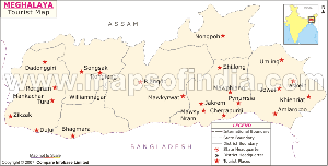
| Click to View Large Meghalaya Travel Map |
Krem Mawmluh is one of the major attractions in Meghalaya. The cave is located near Cherrapunjee. Five rivers make their way through Krem Mawmluh. The height of Krem Mawmluh cave is 4503 meters.
Mawsynram Cave is well known for the huge formation made up of stalagmite. It looks similar to a 'Shivalinga'. The other name for this cave is Mawjymbuin. An upward trek to the peak of the rock offers one, the magnificent views of valleys, hills, the rivers of Bangladesh and the plain. This view makes the cave popular.
The Mawsmai cave is also called Krem Phyllut. This cave is not far away from the Nohsngithiang Falls. The Mawsmai Cave entrance stands in the Mawsmai village near Cherrapunjee. The cave is not far away from the Mawsmai village. The entry point of the cave is vertical and quite narrow. The cave of Mawsmai, one of the prime Meghalaya attractions, is famous for its huge halls and galleys, which connect the different halls of the cave. The halls are similar to amphitheaters.
The Siju cave in one of the important attractions of Meghalaya. It stands on the bank of River Simsang, below Siju village and near Naphak Lake. Located 30 kms towards the north of the place Baghmara, this cave is formed of limestone. The Siju Cave Simsang stalactites resemble the Blue Grotto caves, which form the chief attraction of the Isle of Capri. Among all Indian caves, it is considered the third longest. The cave is also called Dobakkol, whose literal meaning is the bats' cave.
Places to See in Meghalaya
Mawsmai

One can visit this cave in Mawsmai of Meghalaya with an affordable entrance fee. The cave remains open for public viewing from 9 am to 4:30 pm.
The interior of the cave at Mawsmai in Meghalaya consists of big halls. Each of these halls looks like an amphitheater. The cave is embedded in darkness. A torchlight or any other kind of light works wonders on the hidden beauties of this place: the interiors of the cave become illuminated and the stalagmites, stalactites and walls appear to reflect innumerable crystal colors.
The only distinguishing point in all these halls is their varying shapes and sizes. Stalactite and stalagmite myriads lay scattered in the cave. The interior of the cave is quite spacious, which allows one to conveniently move about within the cave.
It is convenient to visit the Mawsmai Cave via Cherrapunjee. Cherrapunjee is at a distance of only 58 kms from Shillong, which is the capital city of the state of Meghalaya. A motorable road links the two places of Cherrapunjee and Shillong. One can avail buses and taxis to reach Cherrapunjee from Shillong by road. The entire journey takes around two hours.
The easiest way to reach Shillong is to travel by air or rail to Guwahati and thereafter drive to Shillong. It takes a total of 3 hours to travel from Guwahati to Shillong by road.
Smit

Smit of Meghalaya is a pollution-free and pleasant village in the outskirts of the capital city. The natural beauty of the place is a treat to the eye. It grows wide varieties of vegetation, consequently sharing to the economy of the state. The farmers of Smit usually practice Jhum cultivation. It also grows considerable amount of spices which are mainly exported to other states. As for the cottage industries in Smit go, sericulture weaving and animal husbandry is widely practiced by the villagers. Smit at Meghalaya is also a site for mining. Kaolinised rocks are found in isolated purchase which stretches over an area of 0.15 km and its average thickness is 2.7.This kaolin adds to the resources of the state as it is suitable for the manufacture of white-wares.
Meghalaya Smit has acclaimed wide recognition for the celebration of Ka Pomblang Nongkrem. Celebrated during autumn, it commemorates the evolution of Khasi democratic states (HIMA), presently functioning under the Sixth Schedule of the Indian Constitution. Previously it was acceded to the Indian Union by signing the Instrument of Accession. Held in November, it is a five-day long thanksgiving ceremony to Goddess Ka Blei Synshar for a rich harvest. Pomblang Ceremony is the most important ritual of the event, where people offer goats to the 'Syiem' of Khyrem, the administrative head of the Hima (Khasi Hills).
Mawsynram
Mawsynram Cave is well known as it is one of its kind. The cave of Mawsynram in Meghalaya makes Mawsynram a popular tourist destination across India as well as the entire world.
To visit the cave of Mawsynram at Meghalaya, one has to come to the east Khasi Hills district of Meghalaya. The airport closest to Meghalaya is located at Guwahati, which is at a distance of 128 kms from the Meghalaya capital, Shillong.
Mawsynram of Meghalaya is located at a distance of 56 kms from Shillong. It is situated around 1 km towards the north of the village of Mawsynram. This place is famous for the gigantic formation of stalagmite, which resembles the shape of a 'Shivalinga'. This formation is housed in a cave, whose local name is Mawjymbuin.
The peak of the rock can be reached by an upward trek from the base of the formation, though it needs trekking expertise to be able to do so. The valleys, the spectacular hills thats surround the region, the speedy rivers of Bangladesh and the plain are all easily visible from the tip of the rock and this view is the attraction of the place.
An extraordinary rock formed by geological means called Symper Rock is located close to the Weiloi Village, at a distance of one and half kilometers from the Ranikor-Balat-Mawsynram-Shillong Highway. This rock formation has a more or less flat top. Its body resembles a dome, which looks like a loaf. It ascends abruptly from among the hillocks of the surrounding region.
Krem Dam cave
The Krem Dam cave situated in the state of Meghalaya is indeed a mesmerizing spot to witness mother nature's splendor at its very best. The Krem Dam is in fact the biggest cave in the the entire subcontinent of India which is constructed totally from sandstone. It succeeds to draw a healthy crowd owing to its mammoth size. The Krem Dam of Meghalaya stretches across a length of approximately 1297 meters.
The heavenly delectable river that spans across the Krem Kotsati can be spanned by two possible ways. One way involves swimming and in the other way you can utilize a rubber boat that can be inflated by air.
All in all, Krem Kotsati in Meghalaya is so gorgeous that you will fall in love with its innocuous presence and the amazingly pristine ambiance that prevails there.
Krem Lashinng
Krem Lashinng located at a distance of approximately 37 kilometers from the rural settlement of Jowai, is one of the 1000 caves cradled in the heart of Meghalaya. If you possess a mellow spot for caving in your heart, then the state of Meghalaya will beyond a shadow of a doubt thrill you.
One of the most significant and sought-after caves in the state of Meghalaya is Krem Lashinng. This is a mammoth cave as it measures approximately 50 meters in width and a staggering 40 meters in height. With these vital statistics, Krem Lashinng in Meghalaya, serves to be one of the chief crowd attractors.
On your cave expedition, make sure that an expert guide escorts you as these caves can indeed turn out to be quite treacherous if safety measures are not properly taken. You also should carry ample amounts of medical aid in case there are any unfortunate accidents.
The Krem Lashinng of Meghalaya is entirely immersed in a humongous pool of mud. Apart from being glutinous, the mud also possesses the quality of being extremely slippery. Thus, it becomes even more essential to take adequate safety precautions to taboo all kinds of mishaps.
Despite the slight inconvenience, Krem Lashinng is indeed bestowed with scintillating beauty and unparalleled charm. Make a point to visit the Krem Lashinng during the months of February and the months of March so that you can avoid the sticky mud. Another reason that attracts the visitors to the Meghalaya Krem Lashinng is its astonishing length of approximately 1650 meters.
All in all, your journey to the Krem Lashinng is sure to be an absolute delight.
Krem Mawmluh
Krem Mawmluh is a cave, which is located at a distance of about half a kilometer towards the west of Cherrapunjee. It is very close to Mawmluh. As many as five rivers pass through Krem Mawmluh at Meghalaya. The cave is 4503 m long and is ranked fourth among the longest rivers of India.
To visit this outstanding cave, one has to first reach Cherrapunjee. Cherrapunjee is located at a distance of 58 kms from the capital city of Meghalaya, Shillong. There is a motorable road that connects Cherrapunjee and Shillong. The common means of road transport are buses and taxis. It takes around two hours to travel from Shillong to Cherrapunjee by road.
Shillong is devoid of any railway station or airport and visitors have to reach Cherrapunjee by road. Meghalaya Tourism buses ply regularly between Cherrapunjee and Shillong. Shared taxis are also available to the tourists to travel from Cherrapunjee to Shillong.
The most convenient way of reaching Shillong is to travel to Guwahati by air or by rail and then reach Shillong by road. It takes three hours to drive from Guwahati to Shillong.
To visit Krem Mawmluh, it is convenient to stay at Shillong, which offers a variety of accommodation options. Some important hotels in Shillong are:
- Hotel Polo Towers
Polo Grounds, Shillong - Centre Point
Police Bazar, Shillong - Tripura Castle
Cleve Colony, Shillong - Pegasus Crown
Ward's Lake Road, Police Bazar, Shillong
Krem Soh Shympi
Meghalaya is not only famous for its natural beauty and tranquility it has some more hidden things in its wallet. This north eastern state is a place of variety which is recognized as the ultimate tourist destination of India. Meghalaya is also designated as a state of caves which contains numerous caves in its land which are completely different from each other in their sizes and shapes.
Krem Soh Shympi is a big and deep cave which is situated in Mawlong that is located in the West Khasi Hills. The cave of Krem Soh Shympi is situated in the hills with an impressive proportion. The entrance of this massive cave is very interesting. The front door of the cave has a 20 m deep pothole entrance and the total length of the cave is 760 m.
The inner passage of the cave is fairly wider than what is normally found in other caves. Thus it gives facility for easy movement in the cave. Though having a mysterious look, the beauty of this giant cave is very impressive The Krem Soh Shympi cave is so deep inside that the natural source of light never enters into it. If anyone wants to go inside the cave then he has to carry some artificial resource to put light into the walls and passage of the cave. Krem Soh Shympi cave of Khasi Hills is one of the major attractions of the state of Meghalaya.
Krem Umshangktat
Krem Umshangktat relishes the reputation of being one of the most coveted caves in the state of Meghalaya which remains jam-packed with anxious eco-tourists as well as fun-seeking holiday-makers. Although setting out on caving expeditions might appear to be an easy task, it requires a lot of training and physical strength to accomplish it successfully.
Humongous flocks of Speleologists or more precisely 'cavers' descend from varied nooks of the globe to embark upon a mesmerizing odyssey through the mysterious caves housed in the state of Meghalaya. A sum total of 1000 caves bless the state of Meghalaya with their awesome presence. But if you desire to explore these cryptic caves, you must seek the professional guidance of an elite guide who is well acquainted with the mazes existing inside these caves.
In fact, the longest cave in the state of Meghalaya is known by the name of Krem Laitprah or Um Imladit. This gigantic cave extends across a length of 22.2 kilometers.
Krem Umshangktat in Meghalaya is blessed with an entranceway that is approximately 350 meters long and its floor is composed of damp sand. To reach the entrance located at an elevated level, you will have to undertake a feeble assent over chunks of limestone and demolished rubble. The sojourn through the Meghalaya Krem Umshangktat gets really tough as the caver has to crawl upon his tummy to get to the hefty vestibule that stretches across a distance of 955 meters.
Although the journey through the Krem Umshangktat of Meghalaya is quite tedious but once you reach the end you will be filled with a sense of joy and delight.
Krem Sweep
On your odyssey to the delectable locale of Jowai make it a point to pay a brief visit to the Krem Sweep as it is bestowed with awesome features that will surely take your breath away. You can reach the Krem Sweep at Meghalaya quite easily as it is only 47 kilometers away from Jowai.
Another key attraction of the Krem Sweep of Meghalaya are the exquisite stalactite and stalagmite formations which is a spectacle in itself. As a matter of fact, the stalactites are a variation of a speleothem or 'cave formations' comprising of secondary minerals which dangle from ceiling of the caves. These are principally seen in those caves that are blessed with an abundant supply of limestone. Sometimes, the stalactites also emerge out from the walls of such caves. Another name bestowed to the stalactites is 'dripstone'.
Chiefly, these are constructed from calcium carbonate deposits. Its counterparts that rises from the floor of such caves are designated as stalagmites. If these two structures develop over a relatively long period and finally meet, a 'column' is formed.
A tiny drop of water gives rise to the stupendous stalactites as well as the stalagmites but it should contain deposits of minerals like calcium carbonate. Slowly but surely a hollow stalactite tube begins its journey destined towards the floor. At this preliminary point, it is referred to as 'soda straw'.
When you tour the Krem Sweep in Meghalaya be sure not to touch any of the stalactite or stalagmite formations as the oily secretions of the skin might alter its structure.
You can also reach the Meghalaya Krem Sweep by traveling through the path that extends from the rear end of village school.
Siju
The Siju cave is situated near Naphak Lake, on the river bank of Simsang below Siju village. The cave is 30 kms to the north of Baghmara. This cave is made up of limestone. The Simsang stalactites available in Siju cave are similar to the Blue Grotto caves, which are found at the Isle of Capri. It is ranked third longest among all the caves of India. The local name of this cave is Dobakkol, which literally means the bats' cave.
This cave of Siju in Meghalaya has many unexplored labyrinths and chambers. The cave is quite deep, though it has not yet been measured accurately. Till date, it has been possible to explore only 1 km of its total depth. The cave at Siju of Meghalaya still lies in complete darkness. The perennial stream flowing out of the cave is home to a variety of aquatic life. A thick layer of droppings of bat cover the cave floor. Wonderful stalagmites and stalactites are found in the cave.
Siju boasts of a few fine river passages, which are globally acclaimed. The other attraction of this cave at Siju is the majestic rock formations of limestone, particularly the one termed 'Princess Di's Chamber'.
Very near to this cave is the other attraction of Siju - Siju bird sanctuary, which is located on the opposite side of River Simsang. It houses quite a few protected and very rare wildlife species including birds. The Siberian ducks migrate to this bird sanctuary in the cold months of winter. The entrance of Siju bird sanctuary has a 1 km steep climb, followed by a collection of beautiful rock formations.
Syndai village
The Syndai village of Meghalaya is a famous village of the Jaintia Hills. Jaintia Hill which is a homeland of the Jaintia tribes is a famous place blessed with natural beauty which gives an aesthetic feeling to the visitors. Most of the beautiful and famous tourist places of Meghalaya are located in different corners of the Jaintia Hills.
The Syndai village of Meghalaya which is located in the Jaintia Hills holds a historical importance. This village is situated in the Jowai-Dawki Road and is known for the number of caves and caverns that it has. These caves of the Syndai village are popularly known as Syndai caves.
The mysterious caves of the Meghalaya village Syndai was constructed years ago. It is said that the Garo people used to hide themselves in those caves. By nature the Garo people are very brave and united. They never like any other community to intrude into their inhabited places and belonging. Thus they often used to involve in serious fightings especially with the foreign intruders who used to enter.
The Syndai caves were used by them as their place of hiding during the war time.
Syntu Ksiar
The mesmerizing land of Meghalaya is loaded with numerous tourists hubs that will beyond a shadow of doubt blow your mind. If you desire to spend couple of moments in the midst of opulent scenic grandeur, Syntu Ksiar is the spot that would certainly live up to your expectations.
Syntu Ksiar is the name dowered to a humongous puddle that comprises of emerald blue waters supplied by the mammoth rivulet entitled Myntdu. Literally meaning 'golden flower' if translated roughly, the Syntu Ksiar in Meghalaya is indeed a tourist destination that is bestowed with such a heavenly charm that it captivates the on-looker in a state of trance.
Being carefully positioned at the Jaintia Hills District of the state of Meghalaya, you can conveniently approach the Syntu Ksiar from any wing of the country.
The secret that lies behind the dazzling beauty of the Syntu Ksiar of Meghalaya is that the sprawling river, Myntdu that feeds it, stretches across an entire arch beleaguering the venue of Jowai. In doing so it almost comes to an abrupt halt that further augments it splendor. Again, it emerges from virtually nowhere with brute force to wow the unsuspecting spectators. This spectacular act of vanishing into the cradle of the Syntu Ksiar and again reappearing within the blink of an eye performed by the Myntdu river, is truly marvelous.
Another sight-seeing spot that lies adjacent to the picturesque locale of Syntu Ksiar at Meghalaya is the Kiang Nangbah Monument which also draws a hefty bunch of eager visitants all throughout the year.
Nartiang
The Jaintia Hills district of Meghalaya houses an entire caboodle of delectable tourist destinations which are always throbbing with anxious holiday-makers. Nartiang is one such venue that holds a special position in the hearts of the occupants on the state of Meghalaya. Apart from serving as tourist spot, Nartiang also possesses historic as well as archaeological significance.
The monarchs belonging to the Jaintia dynasty had augmented their empire by vanquishing the niggling chiefs who had small provinces cradled in the heart of the immense Brahmaputra and the Surma valleys. Thus, Nartiang in Meghalaya gained even more importance as it metamorphosed into the nerve center for carrying out all sorts of commercial and administrative proceedings with the kingdoms of Ahom and Kancheri that lied in the Brahmaputra Valley. Nartiang of Meghalaya even rejoiced the coveted designation of being the functional capital of the Jaintia rulers at the termination point of the 16th century. The most prominent and legendary archaeological remains of Nartiang at Meghalaya include :
This exquisitely carved shrine devoted to Lord Shiva served to be the secret spot for hiving away all kinds of arms and ammunitions used by the Jaintia rulers. Lying to the western fringe of the Durga Temple, this abode of Lord Shiva is positioned at the acme of a magniloquent knoll.
A sprawling plot measuring approximately 100 meters in diameter houses a vast array of single stones in the form of an obelisk or a column. The tallest of the stones has the vital statistics of being 2 meters in breadth, 8 meters in height and 0.46 meters in thickness. The Nartiang weekly bazaar known as Law Mawlong lies at the northern brink of Nartiang.
Jaintia Hills
Jaintia Hills at Meghalaya is the home of the Jaintia tribes. The district of Jaintia Hills was formed in the year 1972. Jaintia Hills is one of the most exuberant and beautiful locations in Meghalaya. The place which is surrounded by nature from every side is a perfect retreat from the hustle and bustle of the city life.
The surrounding meadows, forests, water lakes, rivers, plateaus, etc. are the main charm of Jaintia Hills in Meghalaya. The place has been a home to many wildlife species and floral variety. Jowai which is the headquarter of Jaintia Hills is only 64 kilometers away from Shillong.
The nearest airport would be the Guwahati airport and the nearest railway station would be the Guwahati railway station. From there you can catch any bus for Shillong and from there you can pick up any local transport to reach Jaintia Hills.
The must visit places at Jaintia Hills of Meghalaya are listed below :
- Syntu Ksiar : This is one of the best picnic spots as you can enjoy amidst the cool breeze of river Myntdu which flows across it. The river circles the whole Jowai town and the land appears to be glowing like a Golden flower.
- Thadlaskein Lake : It is situated 8 kilometers away from Jowai and is believed to have been dug up with the tip of the bow by the followers of one of the very famous leaders of Jaintia Hills, Sajar Nangli. The lake falls in between the route of Shillong from Jowai.
- Syndai : Situated in the Jowai-Dawki road, it is an important village which comprises a large number of caves and caverns scattered all across the village. These caves and caverns all together are known as Syndai caves.
- Nartiang : The place is a must visit for it offers a wonderful view of standing rocks. One of the rocks is believed to be the walking stick of Jaintia legend Mar Phalyngki. Some of the clusters of rocks are tallest in the world. The place is just 24 kilometers away from Jowai.
Jowai
Jowai is a picturesque, hammock infested urban settlement that thrives at a distance of 65 kilometers to the eastern brink of the popular hill station, Shillong. Being positioned at an altitude that measures at a staggering 1380 meters from the sea level, Jowai of Meghalaya is blessed with breathtaking natural glaze and a placid ambiance that conquers a cozy position in the hearts of the observers for eternity.
In fact, Jowai also serves to be the coveted headquarters of the Jaintia district whose resident tribes dwell under the impression that they are the ultimate successors of the mighty Mongolians. Since, Jowai in Meghalaya is situated at a stone's throw from the enthralling tourist hub, Shillong, it can be accessed by boarding the buses that leave for Silchar. These buses depart from the Burrabazar bus stand of Shillong.
The awesome grandeur of the town of Jowai at Meghalaya is further intensified by the blessed presence of the Myntdu river that spans across the entire length of the town. If you desire to get rid of all your vexations and spend some quality times with your family and loved ones, Jowai will certainly not disappoint you.
The prominent tourists attractions located close to Jowai include a tomb built to commemorate a lion-hearted freedom fighter,U Kiang Nongbah who embraced martyrdom with a smiling face in the epic battle against the all-mighty British in 1863, a bridge solely constructed from an assemblage of titanic stones that is located at a length of 16 kilometers and many more. It has been conjectured that the primary inspiration behind the construction of this mammoth bridge came from Mar Phalyngki and U Luh Lyngsor Lamare.
Another spectacle near Jowai is a an artificial lake known as Thadlaskein lake constructed by Sajar Nangli. You can also take the pleasure of boating in this lake.
Garo Hills
The magniloquent Garo Hills are exquisitely positioned across the the state of Meghalaya in India. They constitute a fraction of the Garo-Khasi hills which serves to be one of the chief attractions of the state of Meghalaya. The Garo hills procure a dwelling place for the individuals belonging to the various tribes in Meghalaya.
The Garo Hills in Meghalaya cherish the reputation of being one of those destinations on earth that receives humongous proportions of rainfall owing to the subtropical climate that predominates here. The damp ambiance has also facilitated in the growth luscious green forests of the sub-tropical nature.
The functional capital of the state of Meghalaya, Shillong, is in fact cradled in the heart of Garo Hills. Three conspicuous districts constitute the Meghalaya Garo Hills.
The second largest urban settlement is however Tura that houses a staggering 70,000 residents. The Garo hills of Meghalaya remains under a humid blanket of clouds virtually all throughout the year. It is cribbed on the foothills of the mammoth Garo Hills of Meghalaya. The Garo hills are also dowered with gorgeous flora as well as ample fauna.
There are a huge number of tourist destinations that will beyond a shadow of a doubt wow you. They include the following:-
- Tura Peak that stands at a height of 872 meters. There are a number of bungalows that provide comfortable accommodation.
- Bhaitbari comprise of a petite rural settlement on the fringe of the rivulet called Jinjiram.
- Kata Beel is a sprawling pond.
- Darga of Hazrat Shah Kamal Baba or the Pirsthan.
- Nokrek is a stupendous knoll that stands at an astonishing 1412 meters.
Nokrek Peak
The highest peak of the Tura range is the Nokrek Peak. In the district of West Garo Hills, the Tura range is one of the major mountain ranges. Its length is around 50 kms and it has an east-west stretch from Siju to Tura of the district of South Garo Hills. The Tura range is currently under the management of the famous Nokrek National Park. The Nokrek Peak stands at a distance of 13 kms towards the south-east of Tura.
The Nokrek Peak of Meghalaya is the highest peak of not only the Tura range but also the entire Garo Hills. The height of the Nokrek Peak is 1412 meters above sea level. It is covered with tall, dense and green forests. It is considered as a national biosphere and is controlled and managed by the forest department of the state of Meghalaya. A rare citrus fruit species is found on the Nokrek Hill. It is also called 'memang narang'.
This fruit is declared the parent fruit of all the other different kinds of citrus fruit found across the world. To preserve this ancient fruit, a gene sanctuary has been established here, which is the first of its kind in the world.
You can reach the Nokrek via the Daribokgre-Asanangre-Tura road. You can reach the Nokrek Peak in Meghalaya after trekking for a distance of three and a half kms trek from the village of Daribokgre. It houses varied wildlife like rare bird species, wild elephants, orchids of rare fruit.
Tura Peak
The Tura Peak is one of the major peaks of the Tura range. The Tura range represents one of the chief mountain ranges of the Meghalaya district of West Garo Hills. It stands as high as around 50 kms. The range spans from Siju to Tura from east to west in the Meghalaya district called South Garo Hills. The Tura range is managed and looked after by the Nokrek National Park.
An observatory, a tourist bungalow and a Cinchona plantation are housed on the well known Tura Peak. The most important attraction of the Tura Peak in Meghalaya is a fantastic view of plains of Bangladesh, which take on a yellowish hue and the the lower part of the Brahmaputra Valley.
The deputy commissioner of the region of Garo Hills lived in a cottage on the Tura Peak in summer time. From there, he used to regularly travel downwards to the town of Tura on the back of an elephant.
The gigantic Tura hill stands in the eastern region of the town of Tura, which is the biggest town of the entire area of the Garo Hills in Meghalaya. It stands as tall as 872 meters above sea level. It is locally believed that the Tura Peak of Meghalaya is a sacred place where the gods stay. According to popular belief, it was originally named Dura, but the British government mistook the name for Tura and since then it came to be known as Tura. The Tura town catchment area comprises of the Tura hill including its peak and therefore, the Tura range is considered a reserve forest.
Balpakram
Balpakram is a wild life park of Meghalaya. It is located at a distance of around 45 kms from the place called Baghmara. A variety of wild animals like wild cow, wild bison and elephant and very important medicinal plants are found on this plateau of Balpakram in Meghalaya. Keeping this aspect of the Balpakram plateau in mind, the Balpakram National Park has been established here by the government. One can easily visit the Balpakram National Park from the place Sib-barivia via the Shillong-Balut-Ranikor-Moheshkhola-Baghmara Road.
The Balpakram plateau offers a magnificent view of the Bangladesh plains, which is watered by winding rivers and stretches of inland water. Currently, the plateau stands as a solid mass of rubble and rock. According to popular Garo belief, all the pious Garos' souls reside in Balpakram. Therefore, the Garos consider the place as the dwelling place of pious souls.
Balpakram of Meghalaya includes a variety of mysterious sites, some of which are:
Chidmak: It is a small black pool in Balpakram. The Garos believe that the spirits of dead humans wash themselves well in this pool before they go to the world of the dead. According to this mythical association, the sins and the process of cremation of the dead turn the pool water black.
Dikkini Ring: It is a huge flat rock situated in near the village of Mahadeo in the southern region of Balpakram. The shape of this rock resembles an upturned boat. According to Garo myths, a legendary Garo hero, Dikki, was making a boat when the cocks' crowing distracted him and the half-built boat got transformed into stone. This myth confirms the popular belief that the spirits can work only during the night hours.
Imilchang Dare
Imilchang Dare is a waterfall of Meghalaya, which offers a great deal of scenic beauty to the tourists. It is located very near the Chokpot-Tura Road in the Meghalaya district of West Garo Hills. This thick water body forms a spectacular waterfall. The Imilchang Dare of Meghalaya finally drains into a broad, deep pool, which is located at the bottom of the waterfall. This pool is often used as a swimming pool by the visitors. It is home to a variety of fish of different color and size. This place serves as a popular picnic spot.
The waterfall is situated on a stream that makes its way through a crevice rock bed. The bed of the stream is narrow, deep and meandering. This stream finally gushes out of a wide outlet and flows down a wide chasm.
By Air: To visit the Imilchang Dare waterfall, one has to first reach the Garo Hills. The airport closest to this place is located at Guwahati. From Guwahati, one can reach Shillong by a car or a bus. Regular buses are available to travel directly from Guwahati to Shillong. The private company of Pawan Hans Helicopters Ltd operates helicopter flights regularly from Guwahati to Shillong as well as Tura and vice versa., with the permission of the Meghalaya government.
By Road: Ordinary as well as deluxe buses facilitate the communication to the Garo Hills. The association of Meghalaya Road Transport operates buses in the state of Meghalaya regularly.
By Rail: The railhead closest to the Garo Hills is located at Guwahati, which links the place with all the major places of India.
Naphak Lake
Naphak Lake is a lake of Meghalaya, which is located at a distance of 45 kms from the popular tourist destination of Williamnagar. This lake is a popular site for birdwatching and fishing. The Naphak Lake of Meghalaya is a natural lake that was formed due to a natural disaster; a high-altitude tributary of a river was dammed during the massive earthquake of the year 1897. Lake Naphak is situated at a distance of 112 kms from the Tura region close to the river called Simsang.
According to the myths of the Garos, Naphak was once considered the land that belonged to the dead spirits. It is popularly believed that this place was later on left by the spirits, as they started feeling insecure at this place and went to finally settle in Balpakram.
By Rail: The railhead nearest to this place is situated at Guwahati. Trains available from this railhead well connect the place with all the prominent places of the remaining part of India.
By Road: Both the kinds of bus services - ordinary and deluxe, can be availed for road communication in the Tura region. The buses of the Meghalaya Road Transport are also available regularly at the place.
By Air: To visit the Naphak Lake, one has to first reach the Tura region of Meghalaya. The airport closest to this place is located at Guwahati. From Guwahati, one can easily travel to Shillong by boarding a bus or even a car. Regular bus services link up Guwahati and Shillong. Currently, helicopter flights are available on a regular basis, which help to communicate from Guwahati to Tura and Shillong. These flights are operated by a private company named Pawan Hans Helicopters Ltd. which has the license of the state government in Meghalaya.
Tetengkol
Tetengkol is famous for its cave, which is located in the village of Nengkhong, at a distance of 15 kms from Siju. The entrance is not big enough and is circular in shape. The diameter of the entrance is 1 meter.
This small entrance leads to a big cave of length 5334 meter. At present, this cave of Tetengkol in Meghalaya is the second longest of all the caves of India. The Tetengkol cave is also called the cave of inverted-footed dwarfs.
By Road: Many buses are available for the convenience of the tourists. These buses include deluxe buses and ordinary buses. The buses operated by the Meghalaya Road Transport association ply regularly.
By Air: To visit the cave at Tetengkol in Meghalaya, a tourist has to first travel to the Garo Hills. The airport that can be most conveniently reached from this place is at Guwahati. Buses and cars are easily available to communicate from Guwahati to Shillong.
The tourists can avail the bus services, which directly ply between the airport at Guwahati and the capital city of Shillong. The helicopter flights are made available by the Pawan Hans Helicopters Ltd private company.
These flights help to communicate between the three important places of Guwahati, Shillong and Tura. These flights are operated under license of the state government at Meghalaya.
By Rail: The railhead that stands nearest to the Garo Hills is situated at Guwahati. This railhead helps tourists not only from the state of Meghalaya, but from all over the country to conveniently travel to the Garo Hills, the place that houses the cave of Tetengkol, which is one of the Indian caves of international repute.
Bok Bak Dobhakol
The state of Meghalaya comprises of a mind-boggling number of caves that makes it one of the most recurrently visited spots in India. It houses an amazing 1000 caves among which Bok Bak Dobhakol is one of the most famous. Stretching across a length of approximately 1051 meters, Bok Bak Dobhakol truly deserves a huge round of applause. However, one aspect of Bok Bak Dobhakol in Meghalaya precisely demarcates it from the rest of the caves that span across the adjoining plot of land.
The Bok Bak Dobhakol of Meghalaya functions as an emptying spot for the river that borders it. The clean blue waters of the river efficiently sinks in the cradle of the cave named as Bok Bak Dobhakol. But this bizarre phenomenon does not occur all the time.
The Meghalaya Bok Bak Dobhakol serves to be the sole cave that is bestowed with this weird quality and this is visited by a huge number of curious and eager cavers almost throughout the year.
Another feature of Bok Bak Dobhakol is that it gets gorged with humongous proportions of water during the rainy season that makes it virtually inaccessible. Thus if you plan to visit this exquisite cave, make sure that your visit does not overlap with that of the monsoon season.
Also make sure that you carry all sorts of protective gear, as a caving expedition can turn into a catastrophe if proper safety measures are not taken. Also hire a professional guide who can efficiently maneuver you through the mazes of these caves.
Thadlaskein Lake
Tourism has been the lifeline of the economic structure of Meghalaya. Meghalaya boasts of some exquisite natural beauties soothing to the eye. Thadlaskein Lake in Meghalaya adds flavor to this beauty and provide tremendous value for money to the tourists of Meghalaya.
But the only difference between Thadlaskein Lake and other tourist spots in Meghalaya is that it is artificially created and not straight from the hands of God. One happens to reach Thadlaskein Lake on the way to Shillong from Jowai through the paddy fields, grasslands and the deciduous forests of oak and pine. The lake, however, is accessible from these two most popular places of Meghalaya - Shillong and Jowai. Thadlaskein is 56 km away from Shillong and only 8 km from the latter. It is cosily situated off the National Highway 44.
As for the origin of Meghalaya Thadlaskein Lake, it is believed by the local residents that the followers of Jaintia Chieftain U Sajar Nangli (former war leaders of Jaintia) had dug it with their bow tips. Presently, it is situated amidst the rare orchids, meadows and the river Myntdu. The flora and fauna surrounding the lake has an irresistible attraction. Thousands of tourists flock to Thadlaskein Lake of Meghalaya for its serene and refreshing atmosphere. While the vivacious landscape and climate of the state challenges the adventure-maniacs, the tranquility of Thadlaskein Lake at Meghalaya definitely plays its part to meet the demand of the tourists who look for calmness and silence.
Thadlaskein lake hypnotizes the tourists round the year, but the lake can be captured in its full glory from September to May.
Spread Eagle Falls
Meghalaya is replete with diverse flora and fauna and it is well balanced with the waterfalls of the state. In fact, Meghalaya abounds in two 'falls' fresh from the hands of God- the rainfall and the waterfall. While the former has some devastating effects, the latter only provides unalloyed joy to the hearts of the tourists. The Spread Eagle Falls of Meghalaya is one such example of such a source of joy. Spread Eagle Falls, as the name suggests, has its structure similar to an eagle with wide spread wings.
The location of Meghalaya Spread Eagle Falls is in the outskirts of the capital city of Shillong. So it is very easy to get access to the waterfall. It is exactly located about a mile away from the Polo Ground. Spread Eagle Falls at Meghalaya, bubbling down the rocky cliffs, provide great visual sensations to the viewers visiting the place every year. Going with the name, Spread Eagle Falls in Meghalaya has got great height and is sprightly in nature. But this sprightliness is turned into arrogance in the months of rain. The rainfall ranging from 6000-10000 mm annually, the volume of water of the fall increases manifold and then the water gets splashed on the rocks, producing daring and venturous sounds.
The beauty of this Spread Eagle Falls of Meghalaya draws a hefty crowd every year. It is a very popular site of Meghalaya tourism. So if you are in Meghalaya, do include this waterfall in your sightseeing list.
Crinoline Falls
The Crinoline Falls of Meghalaya is situated in the middle of the beautiful city. Near to this fall is the Lady Hydari Park which is a small animal park. The Crinoline Falls with its picturesque beauty attracts visitors across the world. The gargling sound of the falling water could be heard from a couple of meters away from the falls.
The north eastern state of Meghalaya is famous for its picturesque beauty and serenity. There was a time when this state used to be neglected and was nowhere in the tourism list of India. But eventually things have changed a lot. Meghalaya with the growing interest of the state government has developed a lot as an aspiring tourist spot to spend some memorable time along with family and friends.
The top of the falls is mostly covered with green bushes that the falling point is hardly visible to the spectators. At the bottom of this falls, there is a large swimming pool which seduces the swimmers to take a dip into the cold water of the Crinoline Falls in Meghalaya.
The restaurant close to the lake gives an extra mileage to the Crinoline Falls at Meghalaya. Considering the different food habits of the people of different regions, this restaurant has opened its cuisine with a variety of regional, Indian and continental items. The tourism department of Meghalaya regularly holds some occasions and other festivals at the bank of the swimming pool which is an added attraction of this place.
Last Updated on : June 3, 2015
Flights to Meghalaya
Places to Visit in Meghalaya