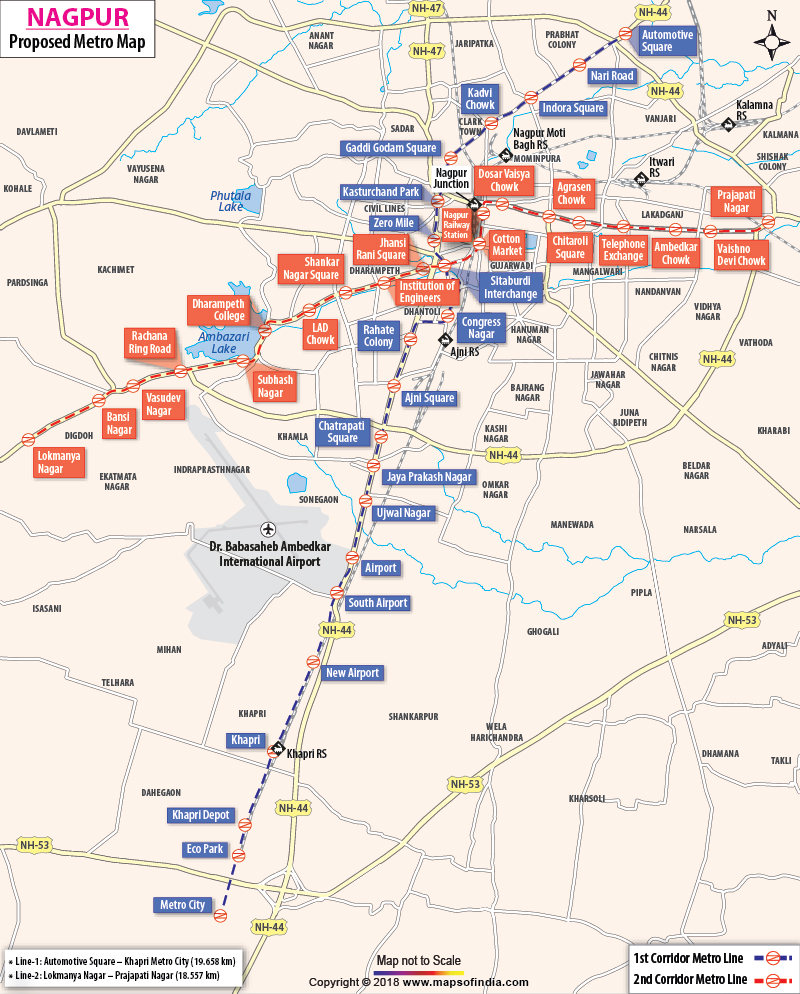
Nagpur Metro Rail Project
With the Nagpur Metro Rail Project receiving clearance from the Union Cabinet on Wednesday, August 20, 2014, Prime Minister Narendra Modi is scheduled to lay the foundation stone of the project today (August 21, 2014). The project, being set up with the objective to reduce the traffic congestion in the urban parts of the city, is expected to be completed by December 2016. The Nagpur metro network has been designed to enhance the city's transportation system, and thereby, help in the fast development of the 13th largest city of the country.
As per the project estimates, Rs 8,680 crore will be invested in the Nagpur Metro Rail Project, out of which Rs 1,555 crore will be contributed by the Government of India. The Government of India will contribute financially to the project in the form of subordinate debt and equity. Also, the project will receive financial support from the Nagpur Improvement Trust, the City and Industrial Development Corporation, Maharashtra Airport Development Company, Maharashtra Industrial Development Corporation and the Nagpur Municipal Corporation.
The project will be carried out under the supervision of the Nagpur Metro Rail Corporation, which will be chaired by the Urban Development Secretary. For the post of the Directors on the Board of the company, there will be 10 nominees, out of which five will be nominated by the Government of India and five by the state government. Also, the Managing Director of the company will be a nominee of the Maharashtra government.
Corridor 1 (North-South): Automotive Square - Mihan
Route Length - 19.658 kilometers
Number of Stations - All Elevated except Airport to MIHAN City route
Link to other Corridors - At Munje Square
| S.No | Station | Route |
|---|---|---|
| 1 | Automotive Square | Elevated |
| 2 | Nari Road | Elevated |
| 3 | Indora | Elevated |
| 4 | Kadbi Square | Elevated |
| 5 | Gaddigodam Square | Elevated |
| 6 | Kasturchand Park | Elevated |
| 7 | Zero Mile | Elevated |
| 8 | Sitabuldi | Elevated |
| 9 | Congress Nagar | Elevated |
| 10 | Rahate Colony | Elevated |
| 11 | Neeri | Elevated |
| 12 | Dev Nagar | Elevated |
| 13 | Mayuresh Apartment | Elevated |
| 14 | Shankar Nagar | Elevated |
| 15 | Old Airport | Underground |
| 16 | Mihan City | Underground |
| 17 | Metro Depot | Elevated |
Corridor 2 (East West): Prajapati Nagar - Lokmanya Nagar
Route Length - 18.557 kilometers
Number of Stations - All Elevated
Link to other Corridors - At Munje Square
| S.No | Station | Route |
|---|---|---|
| 1 | Prajapati Nagar | Elevated |
| 2 | Vaishno Devi Chowk | Elevated |
| 3 | Ambedkar Chowk | Elevated |
| 4 | Telephone Exchange | Elevated |
| 5 | Mayo Hospital | Elevated |
| 6 | Chitaroli Square | Elevated |
| 7 | Agrasen Square | Elevated |
| 8 | Railway Station | Elevated |
| 9 | Netaji Market | Elevated |
| 10 | Jhansi Rani Square | Elevated |
| 11 | Institute of Engineers | Elevated |
| 12 | Bank of India, Shankar Nagar | Elevated |
| 13 | Lad Square | Elevated |
| 14 | Dharampeth Science College | Elevated |
| 15 | Subhash Nagar | Elevated |
| 16 | Rachana Apartment | Elevated |
| 17 | Vasudev Nagar | Elevated |
| 18 | Bansi Nagar | Elevated |
| 19 | Lokmanya Nagar, Depot | Elevated |
WBMA210814

