Dear Friends,
July has been a very special month for the Indians
across the globe with the selection of Taj Mahal as one of the seven wonders of the world by the Swiss-based New 7 Wonders Foundation at a grand ceremony at Lisbon. Celebrating the success of India and its people, MapsofIndia welcomes you to a quick preview of the latest additions and features on its portal and store.
Warm Regards,
Mani Singh
[email protected]
|
|
| In Focus |
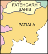 Punjab District Maps
Find updated district maps of Punjab along with brief info on each district in this section. All the districts of Punjab be it Amritsar, Bhatinda, Faridkot, Firozpur, Gurdaspur or Ludhiana are shown with district boundaries, rivers, national highways, roads, railways, district headquarters, towns etc.
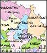 Information on Gujarat
Gujarat situated on the western coast India is a multihued state with a lot to offer. Get an insight into its different aspects including its geography, history, economy, infrastructure, tourism, fairs & festivals, and attractions in this new section. Besides Gujarat fresh segments on other states of India are also being introduced.
 Cities of India
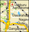
The city sections of India such as Jaipur, Kanpur, Patna, Agra and Bangalore have been revised with new content on a wide variety of topics of interest such as education, tourist points, hotels, real estate and property. Browse through the interesting write-ups and get acquainted with the cities of India in a better manner.
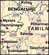 South India Road Map
Are you traveling to South India? Check out this south India road map showing the states of Kerala, Tamil Nadu, Karnataka and Andhra Pradesh. The national highways, roads, railway network, capital cities, and major cities along with state boundaries are shown on this map. This map is a great companion for travelers and tourists.
|
|