
Where is Dadra and Nagar Haveli and Daman and Diu?
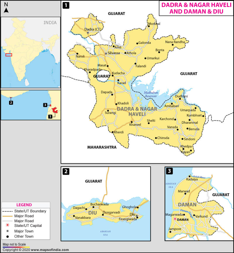
Dadra and Nagar Haveli and Daman and Diu are four distinct pockets or enclaves, which collectively form a Union Territory of India. It lies in the Western part of the country between the states of Gujarat and Maharashtra. Dadra and Nagar Haveli were merged with Daman and Diu to form the new Union Territory of Dadra and Nagar Haveli and Daman and Diu on January 26, 2020. Daman is now its capital.
What is the Geography of Dadra and Nagar Haveli and Daman and Diu?
Dadra and Nagar Haveli and Daman and Diu spread across a total area of 603 sq. km (233 sq. mi). Its population is 586,956 (as per the 2011 census). The population density of the Union Territory was 973.39 per sq. km (2,521.07 per sq. mi) (as per the 2011 census). It was a former Portuguese colony and formally merged into the Union of India on August 11, 1961. It ranks 33rd in terms of area amongst the states and union territories in India. Its mean elevation is 16 m (52 ft) above sea level.
The Union Territory is composed of four well-defined regions situated in western India. Nagar Haveli is a C shaped place lying between the two states Gujarat and Maharashtra, and Dadra is a tiny enclave about a kilometre north of Nagar Haveli, within the state of Gujarat. Daman also comes in the category of the enclave, which is located on the coast of Gujarat. Diu is an island which lies off the coast of Gujarat.
The Daman Ganga, also known as Dawan River, flows through the Union Territory of Dadra and Nagar Haveli and Daman and Diu. The river passes through two states Maharashtra and Gujarat as well. Several industrial towns like Vapi, Dadra, and Silvassa are situated on the north bank of the river, while Daman occupies both banks of the river’s estuary.
The Union Territory of Dadra and Nagar Haveli and Daman and Diu is divided into three districts:
- Dadra and Nagar Haveli district,
- Daman district, and
- Diu district
Dense forests have been found in Dadra and Nagar Haveli district. It is an estimation that around 43 per cent area is under forest cover, while 40 per cent of territory comes under reserved forest. Deciduous forest is present in abundance in the area. As per the forest survey of India report, two major types of forest areas located in the Union Territory are tropical moist deciduous forest and tropical dry deciduous forest. The dominant tree species in the Union Territory are Khair wood and general timber, Sandra, Mahara, and Sisam.
The Union Territory is home to several animal species, such as- leopard, wildcat, striped hyena, golden jackal, and many more. Various kinds of migrant birds are also spotted here like- warblers, flycatchers, buntings, etc. These birds visit each winter.
What is the Climate of Dadra and Nagar Haveli and Daman and Diu?
The Union Territory has a Tropical monsoon climate with hot summers and pleasant winters. The summers are hot and in their later part become more humid, with temperatures reaching as high as 102°F (39 °C) in May. The average summer temperature in Dadra and Nagar Haveli and Daman and Diu remains 35 °C (95 °F) while in winter the temperature dips to 18 °C (64 °F). The monsoon in the Union Territory breaks in June and extends until September. Dadra & Nagar Haveli receives an annual rainfall of around 2,000 mm to 3,000 mm, while Daman and Diu experience an annual rainfall of about 1,687 mm. January and May are the coldest and hottest months, respectively, in the Union Territory.
What is the Economy of Dadra and Nagar Haveli and Daman and Diu?
The economy of Dadra and Nagar Haveli and Daman and Diu mainly depends on industries. The sector is the lifeline for generating revenue in the Union Territory. It has over 7,100 industrial units; out of them, about 85 per cent belong to the MSME sector. Prominent industries of the Union Territory are- polyester and cotton yarn, plasticizers, paper petroleum byproducts, pharmaceuticals, plastics, electrical conductors, and marble tiles. Agriculture is an essential occupation, and the people of the Union Territory produce- paddy, sugarcane, ragi, bajra, jowar, groundnut, pulses, wheat, etc.
What is the Transportation System of Dadra and Nagar Haveli and Daman and Diu?
The Union Territory administration has provided a diverse network of public transportation services to the commuters. People can avail two-wheelers, three-wheelers, and taxis as well. Buses are also available for travelling. Three National Highway passes through Dadra and Nagar Haveli and Daman and Diu, such as National Highway 251, National Highway 848A, and National Highway 848B. All four pockets of this Union Territory are noncontiguous, Daman and Diu are 657 km apart, by road.
Dadra and Nagar Haveli and Daman and Diu has not been well-connected by the railway network. The nearest railway station is Vapi, which is 12 km away from Daman.
The airline network connects the Union Territory to the rest of the country. It has two airports- Daman Airport, and Diu Airport.
What are the Popular Tourist Attractions in Dadra and Nagar Haveli and Daman and Diu?
The newly created Union Territory Dadra and Nagar Haveli and Daman and Diu were under Portuguese control. It is known for its beauty, which entices tourists a lot. The Union Territory has several tourist attractions such as Cathedral of Bom Jesus, Diu Fort, Jampore Beach, Jetty Garden, Somnath Mahadev Temple, and many more. It is such a remarkable place where tourists can enjoy every bit of their time.
Related Map:

![]()


