")
Origin of India-Nepal Tension
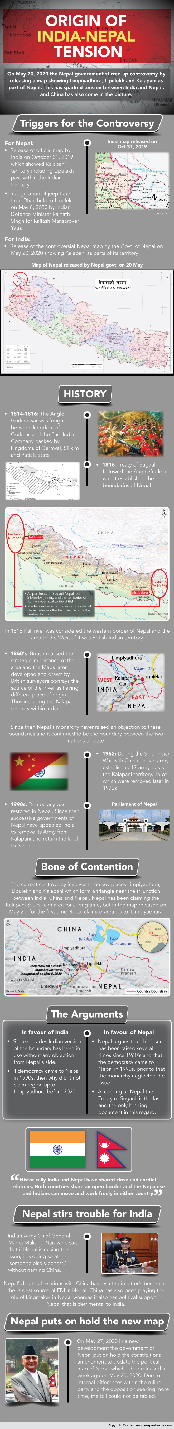
Recently, the Nepal government stirred up controversy by releasing a map showing Limpiyadhura, Lipulekh and Kalapani as part of Nepal. Prime Minister KP Sharma Oli said that the areas belong to the country and vowed to “reclaim” them from India through political and diplomatic efforts. This has sparked tension between India and Nepal, and China has also come in the picture. Here is how the relationship around the India-China-Nepal trio has been developing over the years.
India’s border issue with China and Nepal
India has been facing border issues with two of its neighbours- Nepal and China. The role of Nepal is immense in enhancing the tension between the two most populated countries in the world, China, and India. Therefore, its bilateral relationship with its neighbours is important.
However, on and off, India and Nepal continue to struggle to resolve the border disputes. Nepal claims that the river to the west of Kalapani is the main Kali River; it belongs to Nepal. This river runs along the borders of the Nepalese district of Darchula in Sudurpashchim Pradesh province and the Indian district of Pithoragarh in Uttarakhand state. Such a claim has been made in light of The Treaty of Sugauli which was signed by Nepal and British India on March 3, 1816, and according to the treaty, it locates the Kali River as Nepal’s western boundary with India. Maps later developed and drawn by British surveyors portray the source of the boundary river as having different places of origin. This discrepancy in locating the source of the river led to boundary disputes between India and Nepal. Also, another disputed area, Kalapani has been controlled by India’s Indo-Tibetan Border Police (ITBP) since the Sino-Indian War with China in 1962. However, on May 20, 2020, Nepal launched its map showing Kalapani as parts of its territory.
River Kalapani is another contentious issue between Nepal and India. It is on the Kailash Mansarovar route and located at an altitude of 3,600m. The borders of this location are India’s Uttarakhand and Nepal’s Sudur Paschim Pradesh.
Nepal restores relationship with China
The occupation of Tibet by the People’s Liberation Army in 1950 raised concerns about the security and territorial integrity of Nepal. Therefore, Nepal made an extensive economic and military tie with India.
The bilateral relation between Nepal and China is defined by the Sino-Nepal Treaty of Peace and Friendship signed on April 28, 1960, by the two countries. Nepal and China solved all border disputes along the China–Nepal border by signing the Sino-Nepal boundary agreement on March 21, 1960. Both the governments ratified the border agreement treaty on October 5, 1961. Nepal has been balancing the relationship between competing neighbours since 1975 onward. Such diplomacy has resulted in China becoming the largest source of FDI in Nepal, while India remains one of the major sources of remittance to the country. The Nepali population in India is said to be between 3 to 4 million. A majority of Nepalis who work abroad are employed in India. But since Nepal and India share an open border, there are no official figures.
Economic and strategic relations
King Birendra of Nepal in the late 1970s proposed Nepal as a “zone of peace” between China and India. Several years later, in the 1980s, Nepal started importing Chinese arms and ammunition when the US, UK, and India refused to supply weapons to Nepal. China also allowed Nepal to use several of its ports such as Tianjin, Shenzhen, Zhanjiang, and land ports at Lanzhou, Lhasa, and Xigatse to reduce Nepal’s dependence on India for commercial activities.
India issues a new map in 2019
The Indian Army has been stationed in the Kalapani area near the Lupulekh pass since the 1950s. India withdrew 16 out of 17 border army posts in the 1970s, and one army post had remained at Kalapani. Democracy was restored in Nepal in the 1990s. Since then successive governments of Nepal have appealed to India to remove its Army from Kalapani and return the land to Nepal.
In November 2019, India published a new political map after the bifurcation of Jammu and Kashmir which showed Kalapani territory including Lipulekh pass within the Indian territory.
Lipulekh’s road a controversy
The new road in Lipulekh and India ‘s claim that it is the territory of India has raised the tension between India and Nepal. India claims that Kalapani is a part of the Pithoragarh district of Uttarakhand and Nepal says that it is the part of Dharchula district.
Lipulekh a tri-junction
Lipulekh pass is situated on the top of Kalapani, and it is a tri-junction of India, China, and Nepal. The Lipulekh controversy between India and Nepal started way back in 1997 when Nepal objected to the decision of India and China to open Lipulekh pass for traveling to Mansarovar. The new map issued by Nepal has claimed that highly strategic areas of Limpiyadhura fall in the Nepalese territory.
Nepal stirs trouble for India
India and China have increased their military presence in Ladakh; at this moment, Nepal has also opened its front against India. Indian Army Chief General Manoj Mukund Naravane said that if Nepal is raising the issue, it is doing so at ‘someone else’s behest’. He did not take the name of China.
China has been playing the role of kingmaker in Nepal. As when political crisis deepened in the country, prime minister KP Sharma Oli approached China which saved Oli’s government in Nepal. Currently, China has political support in Nepal that is detrimental to India. Therefore, Nepal is raising new issues against India.


