Chamoli Tehsil Map


Tehsil Map of Chamoli

separator Click here for Customized Maps arrow custom map
 Tehsil Map of Chamoli Uttarkashi Rudraprayag Tehri Garhwal Garhwal Almora Bageshwar Pithoragarh HIMACHAL PRADESH CHINA
Print Email Save Buy Now 
*Map highlights the name and location of all the tehsils in Chamoli district. Disclaimer


  Major Tehsils of Uttarakhand  
Dehradun Tehsil Map Nainital Tehsil Map Almora Tehsil Map Pithoragarh Tehsil Map
Dehradun Tehsil MapNainital Tehsil MapAlmora Tehsil MapPithoragarh Tehsil Map
    
Haridwar Tehsil Map Bageshwar Tehsil Map Tehri Garhwal Tehsil Map Chamoli Tehsil Map
Haridwar Tehsil MapBageshwar Tehsil MapTehri Garhwal Tehsil MapChamoli Tehsil Map
  other tehsils of Uttarakhand  >>

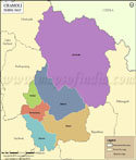
List of Tehsils in Chamoli District

Tehsil/Taluk NameTotal : Rural+Urban Population (2001) in NumberPin Code
Chamoli91,993246424
Gairsain59,383246428
Joshimath39,919246443
Karnaprayag55,170246444
Pokhari35,462246473
Tharali88,432246481


Last Updated on : September 17, 2015