Jammu & Kashmir has always been an integral part of India. Even when India got independence from the colonial rule, Jammu & Kashmir was given a choice to either join India or Pakistan. It chose to be a part of India. There were constant conflicts between India and Pakistan regarding the same. Therefore, it enjoyed a special status in India under Article 370.
A few years ago, the state of Jammu & Kashmir got converted into two union territories, making India a country with 28 states and 8 union territories.
Abrogation of Article 370 and Bifurcation of Jammu & Kashmir
On August 5, 2019, the ruling government in India abolished Article 370 that provided special status to the state of Jammu & Kashmir. Under this article, Jammu & Kashmir was allowed to make its own constitution, have a separate flag and to form their own laws. Following the abrogation, now Jammu & Kashmir will also abide by the Indian constitution like other states and union territories of India.
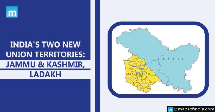
Another proposal put forward was the conversion of the state of Jammu & Kashmir into two Union Territories- Jammu & Kashmir & Ladakh. This proposal was made through the Jammu and Kashmir Reorganisation Act, 2019.
Two new union territories: Jammu & Kashmir, Ladakh
Although the proposal was made in August 2019, the bifurcation took place on October 31, 2019. Now, both the union territories are being governed by Lieutenant Governors. At present, the lieutenant governor of Jammu & Kashmir is Manoj Sinha and the lieutenant governor of Ladakh is Radha Krishna Mathur.
To have a clear understanding of the bifurcation, let us see which union territory constitutes what?
The union territory of Jammu & Kashmir constitutes:
- Jammu Division
- Kashmir Division
- So called Azad Kashmir (POK)
- Gilgit and Baltistan (POK)
- Shaksgam Valley (Under illegal Chinese Occupation)
The union territory of Ladakh constitutes:
- Leh
- Kargil
- Aksai Chin Valley (Under illegal Chinese control)


