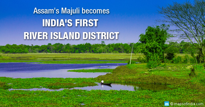
At first, there seems to be hardly anything special about Majuli Island. A nondescript 875 square kilometre riverine island in the middle of the Brahmaputra River. This beautiful island in Assam has made it to the news regularly in recent times, though. On 1 September, 2016, Majuli found a place in the Guinness World Records when it was declared the world’s largest river island, displacing the Marajo island of Brazil, which previously held the record. The Guinness book also notes that Majuli island is home to over 1,60,000 inhabitants. On 8 September this year, the island once again made it to the headlines when it was declared India’s first island district. Earlier, Majuli was a subdivision under the Jorhat district of Assam. It is now the 35th district of the state.
Location And Accessibility
Majuli is a fluvial island formed by the mighty river Brahmaputra, where it branches out as the Kherkutia Xuti to meet the Subansiri, a minor river. The island is located some 2.5 kilometres from the river bank and is at a distance of about 300 kilometres from Guwahati, Assam’s largest and most populous city.
The nearest major city is Jorhat and it is this city that provides Majuli access to the rest of the country. Jorhat airport is well connected by commercial flights from Guwahati and Kolkata, and by train with the rest of the state. Once you reach Jorhat, though, brace for a bumpy long bus ride (due in large measure to the poor roads in the state) to Neemati Ghat. From here, there are two ferry rides to Major Sapori Island each day. These ferries are scheduled to leave at 10 am and 3 pm, but do not expect the local operators to stick to a strict schedule. Now, from the ferry ghat of Major Sapori, hop on to a bus that will take you to another ferry ghat. A short ferry ride and you shall have reached Majuli.
Once you reach Majuli, however, your fatigue and annoyance with the state of public transport in the state is certain to disappear. What Majuli lacks by way of connectivity, it makes up for in natural splendour, warmth, and rich culture. It is also expected that the completion of the Bogibeel Bridge and the construction of the Dhola-Sadiya Bridge (to be commissioned next year) will make Majuli a lot more accessible.
More About Majuli Island
If the many splendid views of the teeming Brahmaputra are not enough, go ahead and visit the twenty one Satras (Vaishnav shrines) on the island. Majuli is a hub of the neo-Vaishnavite culture of Assam and many of these Satras keep the song and dance culture of this heritage alive. Art and culture flourish on this island, home to the Mising, Deori, and Sonowal Kachri tribes of the state. Bird watching is another favourite activity tourists indulge in as hundreds of exotic birds migrate here each year. Apart from Assamese, the locals speak Mising and Deori languages. Do find a local guide if you are not familiar with any of the languages of eastern India.
CM’s Home Constituency
Before you discount Majuli island as a tourist destination and no more, it would be worth remembering that it is from Majuli assembly constituency that Chief Minister of Assam, Sarbananda Sonowal has been elected to power. Quite understandably, the CM visits the island regularly and was a keen crusader for developmental causes in the district. “As Majuli is a treasure trove of potentialities and possibilities, the district has to tread the path of development in tandem with the development initiatives taken in the fields of art and culture, PWD, tourism, rural development, health and sports, agriculture, water resources, soil conservation,” said the CM as he declared Majuli a separate district. He is known to have addressed his cabinet from the island as well underlining the island’s importance in the state.
Erosion And Environmental Damage
Majuli island with its verdant beauty, its cultural treasures, and its warm friendly populace is now on the UNESCO’s tentative list of World Heritage Sites. Despite all the laurels, the island faces a grave danger. By now, the infamous Brahmaputra floods and the erosion faced by its banks in Assam have been reported frequently enough for the nation to be concerned. But what does not seem to have made it to the news is the calamitous erosion faced by this island jewel. Flash floods claim many lives and leave the people marooned each year, but the worst seems to come from constant erosion. Back in the 1990s, the area of the island measured about 1256 square kilometres. By 2014, Majuli has lost over a third of its area as the waters around it continue to swell incessantly.
According to a news report, some 10,000 families from the island have lost their homes and have to be moved to rehabilitate them. The central government has sanctioned INR 250 crore in an effort to protect the island, but those working on its conservation are struggling to stop the island from disappearing altogether.
Read More:
Assam Map
Assam District Map
Districts of Assam
Cities in Assam
Places to Visit in Assam


