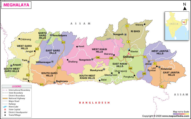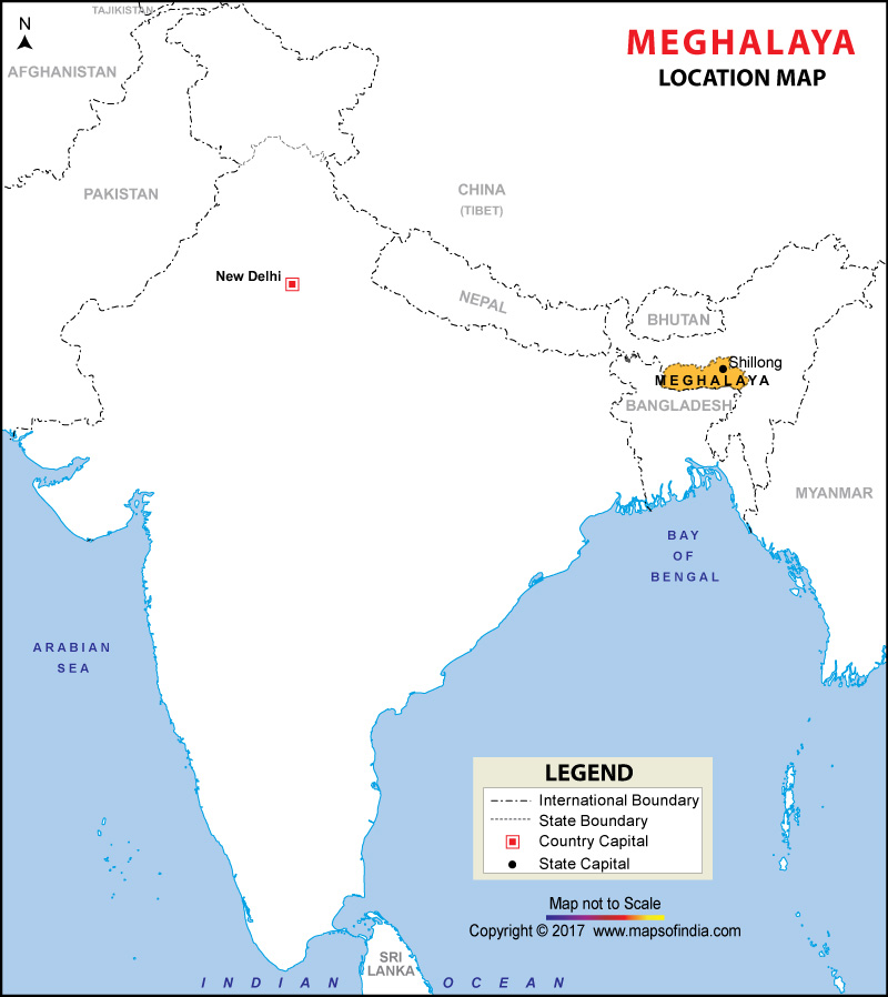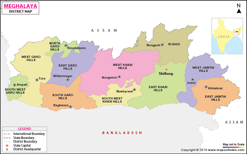

Where is Meghalaya?
Meghalaya is a hilly state that lies in the northeastern part of India. It is surrounded by Assam to the north and northeast and by Bangladesh to the south and southwest. The formation of Meghalaya as a state took place on January 21, 1972. The capital of Meghalaya is Shillong.
What is the Geography of Meghalaya?
Meghalaya spreads across a total area of 22,429 sq. km (8,660 sq. mi). It ranks 22nd in terms of total area amongst the states and union territories in India. Its population recorded 2,964,007 (as per the 2011 census). The population density of the state was 130/sq. km (340/sq. mi) (as per the 2011 census). Meghalaya is in the 22nd rank in terms of population in the country.
It is one of the wettest areas in the world. It is a phenomenal state in the country known for rivers, sanctuaries, and so on. The state has many rivers, which makes Meghalaya entirely exclusive and attractive from other states in the country. Most of the rivers of the state depend on rain hence remains seasonal. The flowing rivers in the state have made various fabulous waterfalls and deep canyons.
Some of the prominent rivers of Meghalaya are Digaru River, Kopili River, Myntdu River, Jinjiram, and many more. Rivers are flowing from the state drain into either the Brahmaputra River or towards Bangladesh.
Shillong Peak is the highest elevation point in Meghalaya, and its height is 1961 meters above sea level. The state has several other peaks, such as Tura Peak, Diengiei Peak, Sohpetbneng Peak, and so on.
The Garo Hill area in the western region of the plateau is almost plain. Nokrek Peak is the highest point in the Garo Hills. Its altitude is 1515 meters.
The state is known for some incredible hills, and some of the significant hills of Meghalaya are Khasi Hills, Jaintia Hills, and Garo Hills.
According to the Meghalaya’s State of Forest Report in 2017, forest covers 17,146 sq km (76.44 %) of the total geographical area. Meghalaya has several essential tree species in its forests, such as Wild Himalayan Cherry, Dieng ling, Teak, Segun, Khasi pine, etc.
It is home to several species of mammals such as elephants, bears, Jackals, Common fox, Sloth Bear, Himalayan Black Bear, and so on. Among the primates, Hoolock Gibbon, the only Ape found in India and Capped Langur, both globally endangered species, are also seen in the state.
Various kinds of birds are found in the state like Long Tailed Minivet, Hill mynah, Golden Fronted Leafbird, and many more.
The state tree of Meghalaya is Gmelina Arborea, while Paphiopedilum insigne is the state’s flower. Besides this, the state has declared Clouded leopard as the official state animal, and Common hill myna is the state bird of Meghalaya.
What is the Climate of Meghalaya?
The climate of Meghalaya usually is mild but varies with the altitude. The weather of the state remains pleasant. The weather of Khasi and Jaintia Hills is enjoyable and energizing because the temperature in both the seasons in summer and winter remains stable and pleasant. However, the climate of Garo Hills remains warm and humid, except in winter. Meghalaya is one of the wettest places in the world, so the sky most of the time remains cloudy.
The average summer temperature in the state remains in the range of 21.2 °C (70.2°F) to 24°C (75.2°F) while the state experiences average day temperature in winter around 19°C (60.8°F) but the night temperature dips to around 10°C (50°F).
The state experiences an average rainfall of around 2600 mm over western Meghalaya, the northern part of the state receives rainfall in the range of 2500 to 3000 mm while the eastern Meghalaya gets annual rainfall around 4000 mm. Mawsynram, a village in Meghalaya, experiences heavy downpour around 11862 mm (467 in) of rain per year.
What is the Economy of Meghalaya?
Meghalaya’s economy mainly depends on agriculture, mining, and tourism. The different kinds of soils, including red-loamy and laterite, are ideal for several crops such as rice, maize, pulses, oilseeds, cotton, and jute. It has also made rapid progress in the cultivation of non-traditional crops like tea, cashew nuts, oilseeds, tomato, mushroom, and so on. It produces high-quality turmeric as well.
Meghalaya is known for hydroelectric power potential. As of March 2020, the state had a total installed power generation capacity of 608.53 MW.
The state has mining deposits in abundance like coal, limestone, kaolin feldspar, quartz, granite, industrial clay, and uranium.
Tourism in Meghalaya is another source of generating revenue, and it is a paradise for tourists. It has national parks and wildlife sanctuaries. Apart from this, tourists get an opportunity to enjoy adventure sports like mountaineering, rock climbing, hiking and trekking, water sports, and so on. The British nicknamed the state “Scotland of the East”. The total number of tourists visited in the state were 1,216,454 in 2018.
Gross State Domestic Product (GSDP) of Meghalaya touched Rs 0.93 trillion (US$ 5.47 billion) in 2019-20.
What is the Transportation System of Meghalaya?
Roads well connect Meghalaya with the rest of the country. Meghalaya Transport Department (MTC) has been providing interstate and across the state bus services.
The national highways are the lifeline for the people of the state. Some major highways pass through the state are NH-40, NH-44, NH-51, NH-62.
The state has only one civilian airport known as Umroi Airport, around 40 km away from the capital Shillong.
The rail network connects Meghalaya now. Prime Minister Narendra Modi inaugurated the 19.75 km long Dudhnoi to Mendipathar railway line in 2014. Its 9.75 km track falls in Assam and 10 km in Meghalaya.
What are the Popular Tourist Attractions in Meghalaya?
Meghalaya is famous for its incredible hill stations that entice people from all walks of life from India and abroad. Heart touching river streams, breathtaking landscapes, and facilities of several adventurous sports are the major attraction for the tourists.
The state has several fantastic tourist attractions, such as Balpakram National Park, Elephant Falls, Double-decker Living Root Bridge, and many more. Tourists will get everything in the state for enjoyment and fun.
Related Maps:


