
About Major Earthquakes, Tsunamis, and Floods
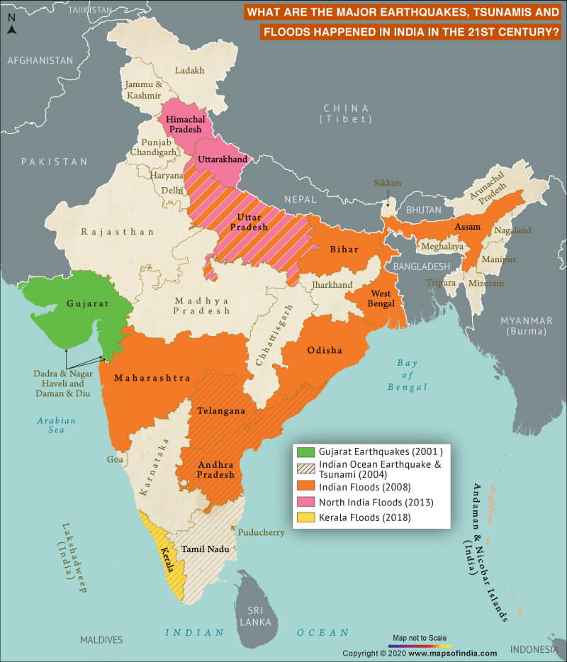
India has had a large number of calamities over the period of time. There have been many in the 21st century itself. Let’s discuss the major earthquakes, floods, and tsunamis in the country which claimed thousands of lives and caused huge losses of property. There have been 5 such major natural disasters in India.
1. 2001 Gujarat Earthquake
Also known as Bhuj earthquake, it occurred on the 52nd Republic Day of India (26 January 2001). It struck Gujarat at 08:46 AM IST and continued for more than 2 minutes. The epicentre was found to be 9 km south-southwest of Chobari village in Kutch District’s Bhachau Taluka. The earthquake destroyed about record 400,000 homes, injured 167,000, and killed between 13,805 and 20,023 people. It reported the intensity of X (maximum felt intensity) on the Mercalli intensity scale and 7.7 on the moment magnitude scale.
2. 2004 Indian Ocean Earthquakes
This earthquake occurred on 26 December at 00:58:53 UTC. The epicentre was recorded to be northern Sumatra’s west coast. It registered a 9.1–9.3 Mw magnitude with IX Mercalli intensity recorded in certain regions. The cause of the quake was the rupture along the fault between the Indian Plate and the Burma Plate. The underwater seismic activity gave birth to large tsunamis which roughly rose as high as 100 ft. These were labelled Boxing Day tsunamis collectively. These killed about 2,27,898 people in as many as 14 countries. It is considered as one of the deadliest natural calamity on the Earth. Communities along the Indian Ocean’s coast were badly affected. The main regions affected in India were Tamil Nadu, Kerala, Andhra Pradesh, Andaman and Nicobar Islands. The confirmed deaths in the country were 12,405.
3. 2008 Indian Floods
In 2008, a series of floods hit India during the months of August and September – the months of monsoon in the country. The main regions affected were Andhra Pradesh, western parts of Maharashtra, and northern Bihar. Regions like Assam, Uttar Pradesh, Orissa, and West Bengal were also affected. The disaster management unit of Ministry of Home Affairs reported that more than 2400 people died due to the natural disaster.
4. 2013 North India Floods
These floods are considered the worst in India after the 2004 floods. The northern state of the country, Uttarakhand, is where the major destruction occurred. The state received rainfall for multiple days. This resulted in floods as the rain was more than what it receives usually. The major overflow occurred as the debris ended up blocking rivers. Flood’s main day was June 16 in 2013. A death toll of 5,748 was recorded with roughly 89% causalities recorded in Uttarakhand. The other parts of India that were affected included Uttar Pradesh and Himachal Pradesh. Over 110,000 people were rescued from ravaged areas with the combined efforts of paramilitary troops, the Indian Army, and the Indian Air Force.
5. Kerala Floods in 2018
Due to the abnormally high amount of rainfall in Kerala, the southern state got severely affected by floods from 9 August. This was also reported to be the state’s worst flood in a century. A loss of around Rs 40,000 crore was estimated. The death toll also reached 483. Fourteen districts of the state were placed on high alert. Severe landslides also occurred.
Related Links:
Map of Major Earthquakes in India
Top 10 Natural Disasters in the History of India


