


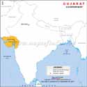
Gujarat is the Westernmost state of India. It is bounded by Rajasthan to the northeast, Dadra and Nagar Haveli and Daman and Diu to the south, Maharashtra to the southeast, Madhya Pradesh to the east, and the Arabian Sea and the Pakistani province of Sindh to the west.
Gujarat came into force on May 1, 1960, carved out of the 17 northern districts of Bombay state when that was split on a linguistic basis (Marathi-speaking). Gujarat is an industrially advanced state, and although it is not a popular tourist destination among foreigners, it still holds an important place in India. The people of Gujarat are also known to be a thriving business community.
The history of Gujarat dates back almost 3,500 years. The archaeological findings at Lothal near Dhandhuka in Ahmedabad district and Razdi in Saurashtra give proof of the Harappan and Mohenjodaro civilization.
The capital of Gujarat is Gandhinagar, and its largest city is Ahmedabad. Its population is 60,439,692, as per the 2011 census. It is in the 9th rank in terms of population in India. The state covers an area of 1,96,024 sq km. It is the 5th largest state in India area-wise. The literacy rate is 70.031 per cent. The language spoken here is Gujarati. It is renowned for its holy temples (Dwarkadheesh temple, Somnath temple), wildlife sanctuaries, beaches, hill resorts, and fascinating colourful handicrafts.
The best time to visit Gujarat is between October and March.
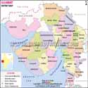
The 33 districts of Gujarat are Ahmedabad, Amreli, Anand, Aravalli, Botad, Banaskantha, Bharuch, Bhavnagar, Chhota Udaipur, Dahod, Dang, Devbhoomi Dwarka, Gandhinagar, Gir Somnath, Jamnagar, Junagadh, Kheda, Kutch, Mehsana, Mahisagar, Morbi, Narmada, Navsari, Panchmahal, Patan, Porbandar, Rajkot, Sabarkantha, Surat, Surendranagar, Tapi, Vadodara, and Valsad.
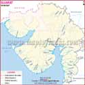
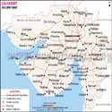
Gujarat Map Overview
The Gujarat map provides a detailed overview of the state’s geographical location, boundaries, districts, major cities, rivers, and important landmarks. Located on the western coast of India, Gujarat shares borders with Rajasthan, Maharashtra, Madhya Pradesh, and the Arabian Sea. A map of Gujarat helps in understanding the state’s administrative divisions, including its 33 districts and their headquarters. The Gujarat political map highlights the boundaries of different districts, cities, and regions, making it easier to study the state’s political and geographical structure. It also showcases important locations such as Ahmedabad, Surat, Vadodara, Rajkot, Gandhinagar, Kutch, Gir National Park, Somnath Temple, and Dwarka. A detailed Gujarat map with district divisions is useful for travellers, students, researchers, and anyone looking to explore the cultural, historical, and economic significance of Gujarat.
Gujarat Districts Map
The Gujarat map provides detailed information about the geographical boundaries, locations, and administrative divisions of the state. The map of Gujarat helps users understand the distribution of districts, cities, and important locations across the state. A detailed Gujarat political map shows the boundaries of different districts and regions clearly.
The biggest district in this state in terms of area is Kutch District, which has Bhuj as its city headquarters. It covers 45,674 sq km, while the population density in the district is 46 square km.
Gandhinagar is the smallest district in terms of area in Gujarat, which covers merely 177 km2 (68 sq mi). It is the most densely populated district of Gujarat at 1,700/km2 (4,300/sq mi). The total population in Gandhinagar is 292,167 (2011 census).
The most populated of all the districts in the state is the Ahmedabad District.
Dang district is the least populated district in the state. Around 228,291 people live here as per the 2011 Census. It covers 1,764 sq km.
Valsad district is located at the Southernmost end of Gujarat. It covers an area of around 2,947.49 km2 (1,138.03 sq mi). It shares its border with Navsari District to the north, Nashik District of Maharashtra to the east, Dadra and Nagar Haveli District of the Dadra and Nagar Haveli and Daman and Diu (DNHDD) union territory and Palghar District of Maharashtra to the south. The Arabian Sea lies west of the district.
Jamnagar district, located on the Southern Coast of the Gulf of Kutch in Gujarat, covers an area of around 14,184 km2 (5,476 sq mi)
The map of Gujarat overview highlights all important locations, districts, and boundaries of the state. The Gujarat state map is useful for understanding the physical and political structure of Gujarat. The political map of Gujarat clearly represents district divisions and administrative regions.
The district map of Gujarat will show you all the districts demarcated clearly in grey dotted lines, and all the district headquarters are marked in grey circles. The map of Gujarat state is also helpful for exploring the major cities, districts, and geographical features of Gujarat.
Some of the Major Cities in Gujarat:
- Ahmedabad
- Surat
- Vadodara
- Rajkot
- Bhavnagar
- Jamnagar
- Junagadh
- Gandhidham
- Nadiad
- Gandhinagar
- Anand
- Morbi
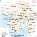
Places to Visit in Gujarat
- Laxmi Vilas Palace - Baroda
- Somnath Temple - Near Veraval
- Dwarakadheesh Temple of Lord Krishna - Dwarka
- Haji Pir Dargah - Kutch
- Gir Forest National Park - Junagadh
- Lothal - near Ahmedabad
- Dholavira - Kutch
- Saputara Hill station – Dang district
- Kirti Mandir - Porbandar
Gujarat State Information | |
|---|---|
| Capital | Gandhinagar |
| Date of formation | 1. May. 1960 |
| Governor | Acharya Devvrat |
| Chief Minister | Bhupendrabhai Patel |
| Tourist attractions | Gir NP, Somnath Temple, Dwarka, Palitana |
| Festivals | Navratri, Kite Festival, Kutch Utsav |
| Major dance and music forms | Dandiya Raas, , Garba dance, Tippani, Padhar Dance |
| Arts and crafts | Bandhani or tie-and-dye fabric; woven Patola fabric; rich embroidery by the Rabari tribals including Soof embroidery. |
| Languages | Gujarati |
| Size | 196,244 sq. km |
| Population (Census 2011) | 60439642 |
| Rivers | Sabarmati, Mahi, Narmada, Tapti, Banas, Saraswati, Damanganga |
| Forests and wildlife sanctuaries. | Gir NP, Wild Ass Sanctuary Kutch, Nal Sarovar Bird Sanctuary, Velavadhar NP, Vansda NP |
| State animal | Asiatic Lion |
| State bird | Greater flamingo |
| State flower | Marigold |
| State tree | Mango |
| Major crops | Groundnuts, cotton, tobacco |
| Factoids | It is possible to climb down the richly-carved step-wells or vavs of Gujarat. |
| The ancient fort Uparkot was first built by the Mauryas. | |
| No. of District | 33 |
FAQs
Q1: How many Districts are there in Gujarat?
There are 34 Districts in Gujarat.
Q2: Where is Gujarat located on the map of India?
Gujarat is located in Western India, forming the extreme western coast of the Indian peninsula.
Q3: Which states share borders with Gujarat?
Gujarat shares borders with Rajasthan, Madhya Pradesh, Maharashtra, and Dadra and Nagar Haveli and Daman and Diu. It also shares an international border with Pakistan.
Q4: What is the capital of Gujarat?
The capital of Gujarat is Gandhinagar.
Q5: Which are the major cities marked on the Gujarat map?
The major cities marked on the Gujarat map are Ahmedabad, Surat, Vadodara, Rajkot, Bhavnagar, Jamnagar, Junagadh, Gandhinagar, Gandhidham, Nadiad, Anand, and Morbi.
Q6: What does the Gujarat political map show?
The Gujarat political map shows the boundaries of districts, cities, towns, and administrative divisions of the state.
Q7: What rivers flow through Gujarat?
The major rivers flowing through Gujarat include the Narmada, Tapi, Sabarmati, Mahi, Banas, and Vishwamitri rivers.
MOI.AB.19.01.17
Maps in Other Regional Languages
Last Updated on: June 24, 2026