
Where is Gujarat?
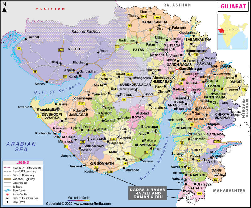
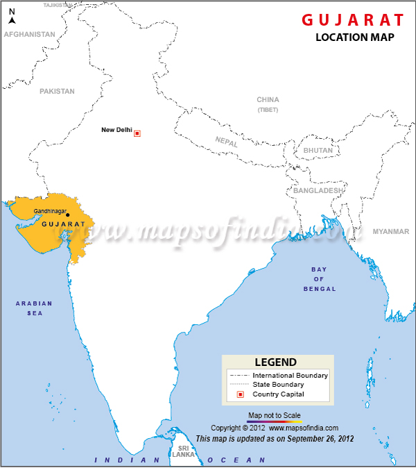
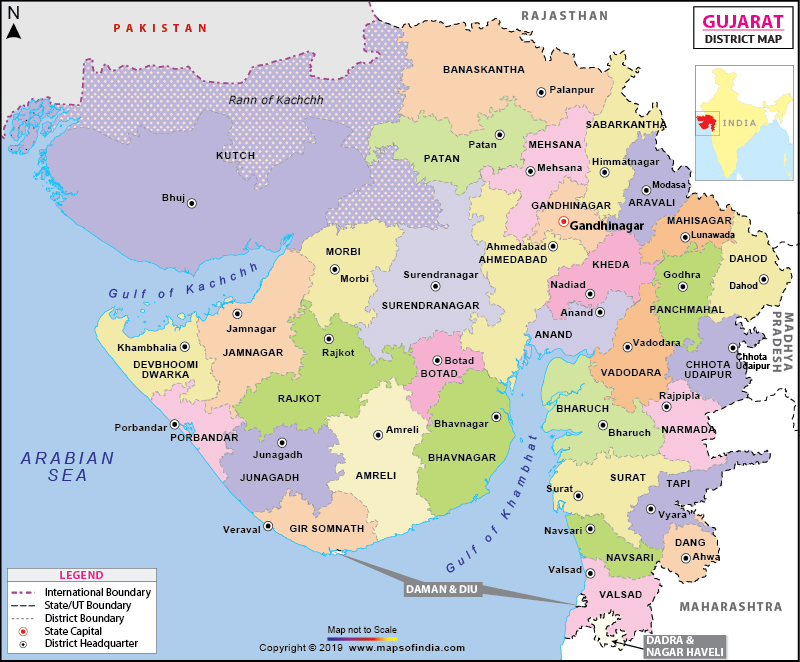
Gujarat is situated along the western coast of India. It shares its borders with Rajasthan in the north and northeast, Maharashtra in the southeast and Madhya Pradesh in the east, Dadra and Nagar Haveli, and Daman and Diu to the south. Apart from these, this state is also bounded by the enormous Arabian Sea in the west and south-west. It also shares a border with Pakistan’s province of Sindh to the northwest. This state came into existence as a new state on May 1, 1960. The capital of Gujarat is Gandhinagar, while Ahmedabad is the largest city in the state. Currently, there are 33 districts in this state.
What is the Geography of Gujarat?
Gujarat is the fifth-largest state of India by area, and it is on the 9th rank in population-wise. The state spreads across a total area of 196,024 sq. km (75,685 sq. mi). The density of the population of the state is 308 per sq. km (2011). The population of the state in 2019 was 68.8824 million.
Gujarat is famous due to the different types of land. Historically the northern part of the state is known as Anarta while the region of Kathiawar peninsula, “Saurashtra,” and the south is famous as “Lata.” This state has the distinction of being the second-longest coastline in the country (24% of Indian sea coast),1600 km, in which there are 41 ports: Out of which one major, 11 intermediate and 29 minor ports. Meanwhile, Andaman and Nicobar island is the longest coastline in India, which is 1,900 km.
The largest river in the state is Sabarmati, then comes the number of Tapti. The Narmada River is also called the Rewa, and is known as the LifeLine of Madhya Pradesh and Gujarat. The famous Sardar Sarovar Project is constructed on the Narmada river in Kevadiya near Navagam in Gujarat. This project has been proving a boon for Gujarat along with three other states of the country, such as Madhya Pradesh, Maharashtra, and Rajasthan. All these four states get water and electricity supply from the dam because electricity is generated from this dam. On September 15, 2019, the water level of the dam had touched 138.68 meters.
Gujarat has several well-known mountain ranges in the country like Aravalli, Sahyadri (Western Ghats), Vindhya, and Saputara. Gir hills, Barda, Chotila, Jessore, and so on are also found in the different parts of this state. However, The tallest peak of the state is Girnar. Meanwhile, there is only one hill-station in this state named Satpura.
The state is replete with national parks and wildlife sanctuaries. The state has four National Parks and twenty-three wildlife sanctuaries, which are managed by the Forest Department of the state government. Various types of trees are found in the Gujarat forest, which is commercially used. The primary species of the Gujarat forest are-Teak, Haldu, Sisam, Khair, Katas, Manvel, and many more. Apart from this, mangrove forests are found in more than 15 districts of this state.
The Asiatic lion is the state animal of Gujarat, while the greater flamingo is the state bird. Banyan is the state tree, and the marigold is the state’s flower.
Different types of soils are present in this state. Clayey soil is generally in South Gujarat and Saurashtra. But in Central Gujarat sandy soil loam to loam is extensively found. While in North Gujarat, an abundance of sandy loam to loam soil is available. Black soil is also found in the state.
Agriculture is a significant source of the state’s income. Gujarat is one of the primary producers of tobacco, cotton, and groundnuts in the country. Also, several other crops like rice, wheat, jawar, bajra, maize, tur, and gram, etc. are extensively cultivated in this state. Gujarat’s economy is dependent on agricultural production.
What is the Climate of Gujarat?
The climate of Gujarat is diverse. The summer of this state is hot and muggy. The day temperature in summer reaches up to 45 °C, and at night temperature drops up to 25 °C. In winter, the temperature varies from 15 to 35°. The southern part of the state and hilly areas get heavy showers during the monsoon, which makes life difficult for the common people. It receives an average rainfall of around 33 to152cms.
The southern part of the state gets rainfall between 76 and 152 cms. Danga district of the state receives maximum average rainfall around 190 cms while the northern part of the state receives average rainfall between 51 to 102 cms. The Gulf of Cambay and the southern highlands of Saurashtra get around 63 cms rainfall while the semi-desert area of the state like Kutch gets very low average rainfall.
What is the Economy of Gujarat?
The economic growth in Gujarat is satisfactory. The contribution of this state in the agricultural sector is immense. It contributes around 19 percent of the state’s GDP.
Reliance petroleum’s Jamnagar refinery is considered as the most significant grassroots refinery in the world. Gujarat is on the second rank in India in gas-based thermal electricity generation. In nuclear electricity generation, this state is on the second spot as well.
Gujarat is an industrialised state of the country. The state is known for the manufacturing of textiles, vegetable oils, soda ash, cement, and many more. Besides, there are many small and big industries running in Gujarat.
Several kinds of minerals are found in this state like calcite, gypsum, manganese, lignite, bauxite, limestone, and many more. The chemical industry in Gujarat contributes more than 35 percent of the country’s total chemical production. Due to industrial growth, the unemployment rate in Gujarat is low. The contribution of industries in the state’s GDP is 45 percent.
What is the Transportation System of Gujarat?
Gujarat is well connected with the entire country by road, rail, and air. But roadways are the chief transport system in Gujarat. The state-run transport is known as Gujarat State Road Transport Corporation (GSRTC). Over 40,000 employees work in Gujarat transport. The state is connected with over 300 state highways, and its total length is 19,761 km and 13 national highways spanning 3245 km
There are 14 airports in this state, and two private airports are also operating in the state. Trains are available from Gujarat for all routes in the country.
Major roadways of this state is-NH-6, NE-1,NH-8A, NH 8-C, NH-8B, NH-8D, NH-8D, NH-8EH-14, NH-15, NH-59, NH-228, NH-113 and many more,
What are the Popular Tourist Attractions in Gujarat?
Gujarat is a paradise for tourists. There are many worth seeing spots for the tourists’ such as-Rani ki Vav (the Queen’s Stepwell), Patan, Modhera, Champaner-Pavagadh Archaeological Park, Statue of Unity, KevadiaIdar Hill Fort, Sabarkantha District. Also, there are many other places which are worth seeing for tourists in Gujarat.
Related Maps:


