
Where is Uttarakhand?
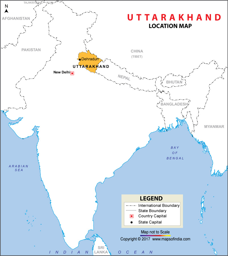
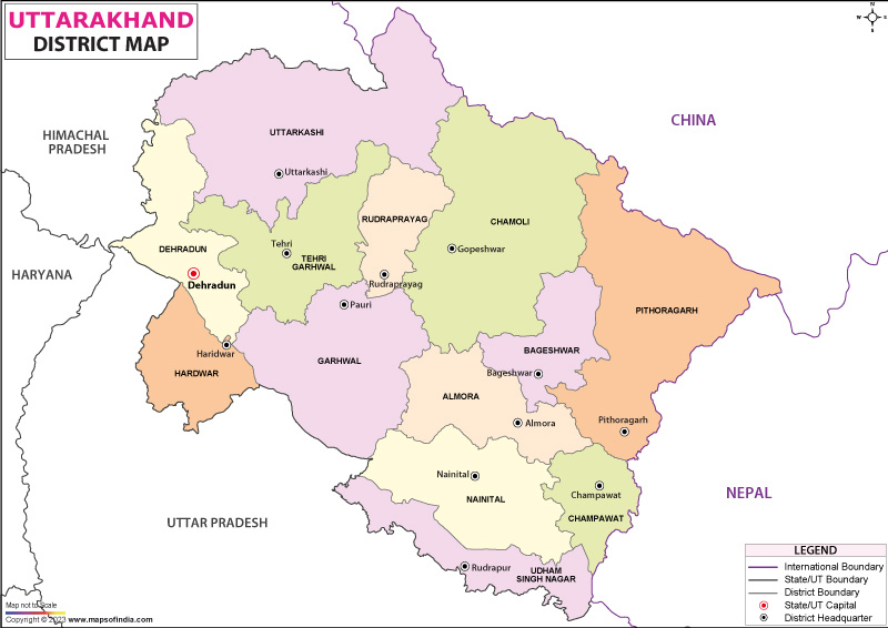
Formerly known as Uttaranchal, the state is in the northwestern part of the country. The state also gained the nickname of “Devabhumi” (land of Gods) due to a great many Hindu temples found here. It is also famous for its natural environment of the Himalayas, the Terai region and the Bhabar. Further, the state divides into two divisions; Garhwal and Kumaon. The natives here are called the Uttrakhandi; either Kumaoni or Garhwali, by their origin in the region. As per the census conducted in 2011, the total population in the state stands at 10,086,292, making it the 20th most populous state in the country. Uttarakhand’s winter capital is Dehradun, which is also the largest city in the state and the summer capital being Chamoli district. The high court is in Nainital.
What is the Geography of Uttarakhand?
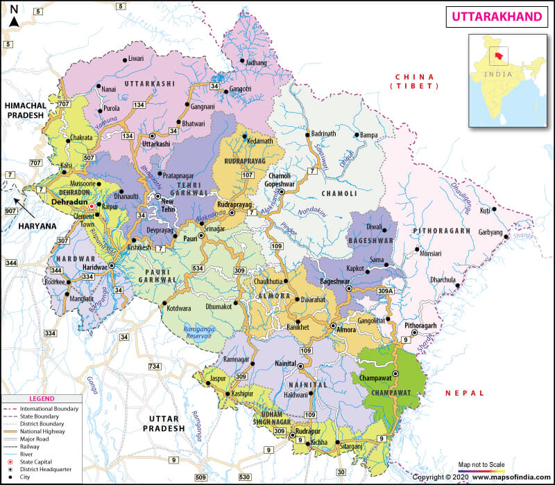
Spread over a total geographic area 53,483 sq. km, of which 65% is covered by forest and 86% by mountains. It is bounded to the Tibet Autonomous Region of China to the north, Uttar Pradesh to the South and Himachal Pradesh west and northwest. High Himalayan peaks and glaciers cover most of the northern part. Uttarakhand lies in the southern slope of the Himalayan region; the climate and herbage here differ with its elevation point; glaciers at the high elevation and forests at the lowest height.
Moreover, the state divides into several physiographic zones that run collateral to each other from northwest to southeast. The northern zone is called Himadri, and it is elevated roughly from 10,000 to 25,000 feet (3,000 to 7,600 meters). To the south Himachal, there is a stretch of the Siwalik Range. And the area containing Himadri, Himachal, and Siwaliks is known as Kumaun Himalayas.
The state is home to one of the oldest forested wildlife sanctuaries, Jim Corbett National Park. It also has a UNESCO World Heritage Site called The Nanda Devi and Valley of Flowers located in the upper expenses of Bhuyandar Ganga near Joshimath in the Garhwal region.
What is the Climate of Uttarakhand?
The climate of Uttarakhand is mild and humane and has seasonal variations in temperature, however, affected by the tropical monsoon. January is the coldest month with an average temperature of below freezing in the north and nearly 21°C in the southeast. On the other hand, May is the warmest month with the daily temperature usually reaching 38° C from a low around 27° C. The state also receives around 60 inches (1,500 mm) of annual precipitation, which is brought by the southwest monsoon. In the lower stretches of the valley, floods and landslides are a problem during rainy seasons.
Besides, four types of forests are here in the state: alpine meadows in the extreme north, temperate forest in Great Himalayas, thorn forest in Siwalik range, and tropical deciduous in lesser Himalayas. As per the reports by the state’s administration, nearly 60 percent of Uttarakhand is covered with forest. Further, the forest furnishes fuel woods and timber.
Common trees that are found here are Deodar, blue pine, oak, silver fir, spruce, chestnut, elm, poplar, birch, yew, cypress, to name a few. Faunas are tigers, leopards, elephants, wild boars, sloth, etc. Lions and rhinoceroses have become extinct here.
What is the Economy of Uttarakhand?
Considered to be the second-fastest-growing economy, Uttarakhand’s gross state domestic product for 2004 is at $6 billion. The state also produces about 8% of the output of the old Uttar Pradesh state. Per capita income in the state is at Rs 1,03,000 (FY 2013), which is higher than the national average of Rs 74,920 (FY2013). As per the reports by the Reserve Bank of India, the total foreign direct investment in the state stands at the US $ 46.7 million from April 2000 to October 2009.
Like many other states in India, agriculture is one of the prime occupations in the state. Though roughly three-fifths of the working population of Uttarakhand is involved in this occupation and less than one-fifth of the total land area is eligible for cultivation. Terrace cultivation is one of the popular methods used for irrigation here. Some widely cultivated crops are various types of millets, sugarcane, pulses such as peas and chickpeas, oilseeds such as soybeans, peanuts, mustard seeds, various fruits, and vegetables.
Many farmers also practice animal husbandry in Uttarakhand. Goats, sheep are found in the mountainous areas, especially in the southern foothills.
Apart from silica and limestone, which are also mined in considerable quantities, other small reserves are gypsum, magnesite, phosphorite, and bauxite.
What is the Transportation of Uttarakhand?
Uttarakhand has a major constituent of the transport system called Uttarakhand Transport System (UTC). One thousand buses run under UTC on 35 nationalised routes along with many other non-nationalised routes. There are private transport operators as well as operating approximately 3000 buses on non-nationalised routes. The state has 28,508 km (17,714 mi), of which 1,328 (825 mi) are national highways, and about 1,543 km (959 mi) are state highways. The busiest airport in the state is Jolly Grant Airport in Dehradun.
Further, the government is planning to develop Naini Saini Airport in Pithoragarh, Bharkot Airport in Chinyalisaur in Uttarkashi district, and Gauchar Airport in Gauchar, Chamoli district. There are several railway tracks as well, which extend from the plains of Uttar Pradesh into the valleys of southern and eastern Uttarakhand. Significant towns that are connected via rail are Rishikesh, Haridwar, Kathgodam, Tanakpur, etc.
What are the Popular Tourist Attractions in Uttarakhand?
Some of the popular tourist attractions in Uttarakhand are Valley of Flowers National Park, Rajaji National Park, Nainital Lake, Nanda Devi, Har ki Pauri Ghat, Laxman Jhula, Auli, Mussoorie, Jim Corbett National Park, Badrinath, Kedarnath, Gangotri, Yamunotri, to name a few.
Related Maps:


