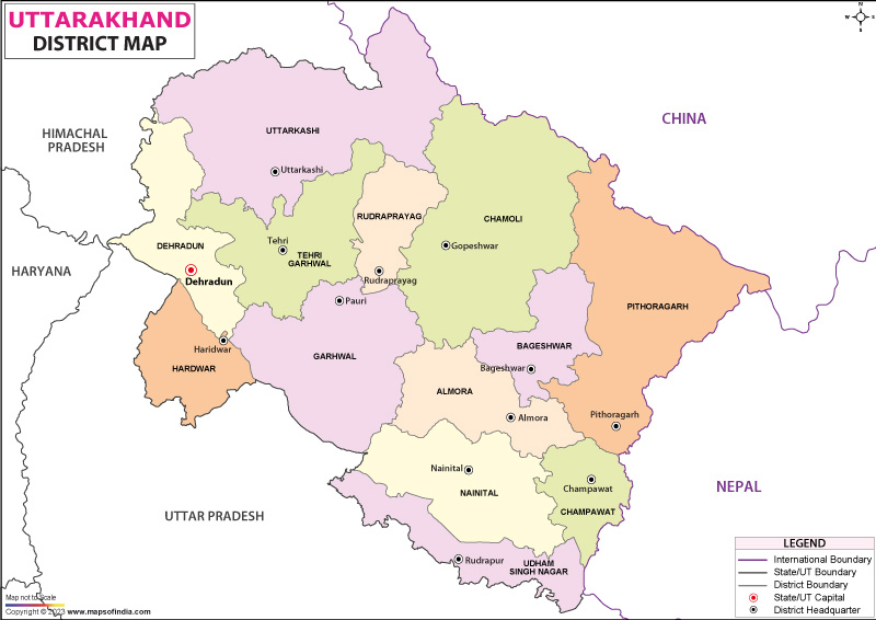
Uttarakhand , one of India's newest states falls in the north of the country between 30° 33'N and 78°06'E. The state lies in the Himalayas though it also includes some area of the plains.
It shares an international boundary with China in the north and Nepal in the east. In the west, it touches Himachal Pradesh , and in the south, Uttarpradesh .
The state spread over 53,566 square kilometers is divided into two divisions of Garhwal and Kumaon and further divided into 13 districts.
The Garhwal Division
The districts which form a part of this division are Dehradun, Haridwar, Chamoli, Rudraprayag, Tehri Garhwal, Uttarkashi, and Pauri Garhwal.
Dehradun district has an area of 3088 sq km. It adjoins the Sirmaur district of Himachal Pradesh with the rivers Tons and Yamuna at the boundary.Dehradun city and Gairsain (Summer)are the provisional capital of the state and has many national institutes located within it. It is also a major rail head in the state. Haridwar district is spread over 2360 sq km. Its headquarters, Haridwar city, is the entry point to the Char Dham pilgrimage.
Chamoli district lies in the Central Himalayas with a total area of 7520 sq kms. The elevation of this district ranges between 800 meters to 8000 meters. Most of the high mountain ranges such as Nanda Devi, Trishul, and Kamet are located in this district. The Alakhanada River flows through the district.
Rudraprayag district is spread over 2328 sq kms. This district has one of the highest literacy rates in the state.
Uttarkashi district lies in the north- west corner of the state with a total area of 8016 sq kms. It is the largest district in the state. The source of both the Ganga (Gangotri) and Yamuna (Yamnotri) rivers is located within this district.
Pauri Garhwal district spread over an area of 5230 sq kms has a varied topography. It has bhabar plains in the foothills of the hills and high meadows at 3000 meters. It is surrounded by the Himalayas and the ranges can be seen from anywhere in the district.
List of Districts in Uttarakhand
| S No. | District | Headquarters | Population (Census 2011) | Sex Ratio (per 1000) | Average Literacy |
|---|---|---|---|---|---|
| 1 | Almora | Almora | 622,506 | 1139 | 80.47% |
| 2 | Bageshwar | Bageshwar | 259,898 | 1090 | 80.01% |
| 3 | Chamoli | Gopeshwar | 391,605 | 1019 | 82.65% |
| 4 | Champawat | Champawat | 259,648 | 980 | 79.83% |
| 5 | Dehradun | Dehradun | 1,696,694 | 902 | 84.25% |
| 6 | Haridwar | Haridwar | 1,890,422 | 880 | 73.43% |
| 7 | Nainital | Nainital | 954,605 | 934 | 83.88% |
| 8 | Pauri Garhwal | Pauri | 687,271 | 1103 | 82.02% |
| 9 | Pithoragarh | Pithoragarh | 483,439 | 1020 | 82.25% |
| 10 | Rudraprayag | Rudraprayag | 242,285 | 1114 | 81.3% |
| 11 | Tehri Garhwal | New Tehri | 618,931 | 1077 | 76.36% |
| 12 | Udham Singh Nagar | Rudrapur | 1,648,902 | 920 | 73.1% |
| 13 | Uttarkashi | Uttarkashi | 330,086 | 958 | 75.81% |
Kumaon Division
The districts which form a part of this division are Almora, Nainital, Pithoragarh, Udham Singh Nagar, Bageshwar, and Champawat.
Almora district encompasses an area of 5385 sq kms.
Nainital district, also called the Lake District due to the presence of lakes in the mountains, is spread over 3422 sq kms. It also has both plain and hilly areas. The district has the important rail link of the North East railways at Kathgodam. High Court of the state is located at Nainital.
Pithoragarh district with a total area of 7217 sq kms is a politically sensitive district as it touches two international boundaries and has strategic passes into Tibet in China.
Udham Singh Nagar district falls in the Terai belt of the Himalayan foothills and has a number of industries located here. It is home to the leading agricultural university at Pantnagar.
Bageshwar district has the Gomti and the Saryu rivers flowing through it. Bageshwar town is the headquarters.
Champawat district spread over 1613 sq kms. The river Kali forms the international boundary with Nepal. The district is separated from Nainital district by a chain of mountains and from Pithoragarh district by the river Ram Ganga.
ABMOD
Last Updated on: January 14, 2026
Uttarakhand Districts
| Buy this Map |
