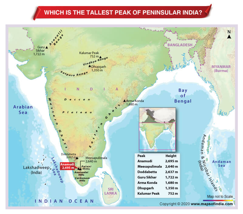

Anaimudi is the highest peak of peninsular India.
Peninsular India comprises Deccan Plateau and the mountain ranges – Aravali, Vindhya, Satpura, Western Ghats, and the Eastern Ghats. Among these mountain ranges, the Western Ghat mountain range is the highest. In fact, the top 3 peaks of peninsular India are located in the Western Ghat range.
Located at the junction of the Cardamom Hills, Anaimalai Hills, and Palani Hills, Anaimudi/Anamudi Peak of Munnar, Kerala, has an elevation of 2,695 meters above sea level. The name Anaimudi literally translates to the “elephant’s forehead”.
Meesapulimala (Idukki, Kerala) is the second-highest peak of Peninsular India with an elevation of 2640 metres above sea level. Doddabetta (Nilgiri, Tamil Nadu), located near Ooty, is the third highest peak with an elevation of 2,637 metres.
The Eastern Ghats are older than the Western Ghats. With an elevation of 1,680 metres, Arma Konda/Sitamma Konda peak (Vishakhapatnam, Andhra Pradesh) is the highest peak of the Eastern Ghats.
Aravali range is the oldest mountain range of India. Guru Shikhar (Mount Abu, Rajasthan) is the highest peak of the Aravali range with an elevation of 1,772 metres above sea level. Dhupgarh (Madhya Pradesh) is the highest peak of Satpura Range with an elevation of 1350 metres above sea level. Similarly, with an elevation of 752 meters above sea level, Kalumar Peak/Sadbhavna Peak (Mandu, Madhya Pradesh) is the highest peak of the Vindhya Range.
Related Link:


