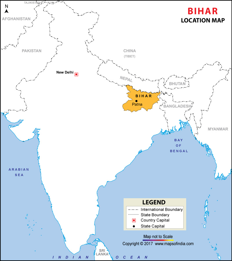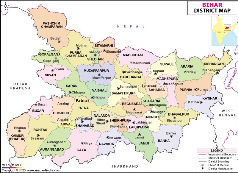

Where is Bihar?
Bihar is an eastern Indian state that is split by the Ganges River. This land-locked state shares its borders with northern West Bengal (to the east), Jharkhand (to the south), Uttar Pradesh (to the west), and Nepal (to the north). On 15 November 2000, the southern part of Bihar was ceded to form the Jharkhand state.
What is the Geography of Bihar?
Bihar is spread across a total area of 94,163 sq. km (36,357 sq. mi), making it the twelfth largest Indian state. While 92,257.51 sq. km (35,620.82 sq. mi) in the state is a rural area, 1,095.49 sq. km (422.97 sq. mi) is an urban area. Three main regions (namely, Magadh, Mithila, and Bhojpur) converge in Bihar. Three types of soils are found in Bihar: Piedmont Swamp Soil, The Gangetic Alluvium, and Terai Soil.
The mean elevation of Bihar above the sea level is 173 ft (53 m). Fort Someshwar of the Sivalik Hills is the highest elevation point in the state. The significant hills are Rajgir hills, Kaimur Range, Bateshwar hills, and Barabar hills. The major rivers of Bihar are the Ganga River, Ghaghra / Saryu, Gandak, Burhi Gandak, Bagmati, Kamla, etc. Kanwar Taal Lake is the major lake in the state. While Manjhar Kund, Dhua Kund, and Sita Kund are the major springs in the state, the significant waterfalls are Kakolat, Telhar, and Karkat.
A vast stretch of the fertile plain is situated in Bihar. The River Ganges flows from the west to east, dividing the landform into two halves. While the northern part of the state has Dharwarian rocks (comparatively younger geological structure), the southern part has quaternary rocks (relatively older geological structure).
Bihar has three distinct landforms: Terai in the North-West part, Plateau in the Southern region, and Gangetic Plain in the central part.
The Shiwalik Range is located in the northern region of West Champaran district and is spread across an area that is 32 km (20 mi) long and 6-8 km (4-5 mi) wide. Shiwalik Range consists of Ramanagar Doon, Someshwar Range, and Haritha Valley.
The Southern Plateau Region is spread from Banka in the East to the Kaimur districts in the West. Hard rocks such as granite, schist, and gneiss make up this region. Batholim such as Jethian hill, Ramshila, and Pretshil form many conical hills.
The Bihar Plain in the central part of Bihar is located between the northern mountains and the Southern Plateau. This plain has two parts: the Northern Plain and Southern Plain. The Northern Plain is found in six districts: East Champaran, West Champaran, Kathihar, Saharsa, Begusarai, and Chaurs of Samastipur. The Southern Plain is triangular. The significant hills in Gaya, Bihar Sharif, Kharagpur, Jamalpur, Sheikhpura, Giriak, and Rajgir come within this region.
Read More: Geography and History of Bihar
What is the Climate of Bihar?
Indian subcontinent’s climatic pattern is found in Bihar. The state has a tropical-to-sub-tropical location, extending from 22-degree north to 27-degree latitude. Bihar enjoys a continental monsoon climate, considering its distance from the sea. The monsoon distribution here is affected by the Himalayan Mountains in the north.
During December-February, the cold weather season is found. The hot weather season starts in March and continues until May. The Southwest Monsoon takes place during June-September. October-to-November is the retreating southwest monsoon season. Summer remains hot, and the average temperature hovers around 35-45 °C (95-105 °F). The lowest temperature during winter hovers within 0-10 °C (32-50 °F). The average annual rainfall in Bihar is around 1,140 mm (45 in).
What is the Economy of Bihar?
Bihar is one of the fastest-growing states in India with the Gross State Domestic Product growing at a CAGR of 11.99% between 2011-12 and 2017-18. The Net State Domestic Product (NSDP) has also grown at a CAGR of 10.16% during the same period. The nominal GSDP increased from Rs. 2,47,144 crore in 2011-12 to 4,84,740 crore in 2017-18 and to Rs. 5,57,490 crore in 2018-19.
It is one of the strongest agricultural states in India. Bihar is the 4th and 8th largest producer of vegetables and fruits in India, respectively. Around 80% of the population is still involved in agricultural production. Some of the fastest-growing industries in the state are healthcare, manufacturing, sugar, dairy, and food processing. The principal industries in Bihar are food and beverages, chemicals, transport equipment, rubber and plastics, dairy, leather, textile, and tobacco.
During 2017-18, the total merchandise export from Bihar was US$ 1,345.31 million, a significant improvement from US$0.4 billion during 2012-13. Export-Import Bank’s (EXIM) report says that Bihar has the untapped potential of exporting around US$900 million. If this potential is achieved, the shipment from Bihar in the short-run will exceed US$2 billion. The total foreign direct investment (FDI) in Bihar and Jharkhand was US$113 million during April 2000-March 2019.
The unemployment rate in Bihar during 2017-18 was 7.2%. While the urban unemployment rate was 9%, the rural unemployment rate was 7%. Bihar has made a significant breakthrough in its economic front through rapid industrialization, improvement in agricultural activity, targeted spending on infrastructure as well as growth, and implementation of fiscal prudence. The poverty rate was 33.74% as per the Annual Report of Reserve Bank of India 2013.
What is the Transportation System of Bihar?
The roadway is the main transport system in Bihar. Some of the main roads are NH2, NH19, NH28, NH30, NH30A, NH31, NH98, NH106, NH110, etc. Major airports in the state are Lok Nayak Jayaprakash Airport (in Patna) and Gaya Airport (in Gaya).
What are the Popular Tourist Attractions in Bihar?
Some of the most popular tourist spots in the state are Nalanda University, Bodhi Tree in Maha Bodhi Temple, Muchalinda Lake, Griddhakuta Peak, Rajgir Hot Springs, Buxar Fort, Navlakha Palace, Hieun Tsang Memorial Hall, Jalmandir Temple, Patna Museum, etc.


