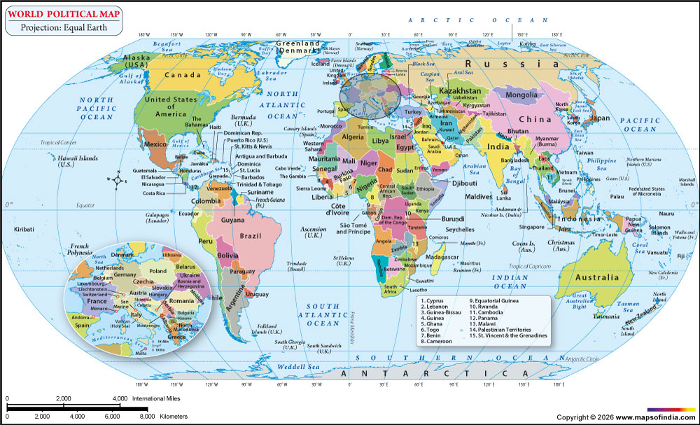



The revised world map can be used to learn about countries, continents, oceans and key geographical features. The balanced design allows it to be used for education, geography reference, presentations, research or general use.
New World Map 2026
The New World Map 2026 uses the Equal Earth projection to represent the Earth's curved surface on a flat map. The New World Map 2026 is a map of the globe's surface, distorted onto a flat surface, using the Equal Earth projection. The Equal Earth projection has been created to maintain the relative land area size, so it is appropriate for comparisons of the size of countries and continents.
The projection is of distinctive appearance; the parallels are curved, and the outline of the world represents a more balanced view of the planet. Countries at high latitudes do not appear to be enlarged as much as they do on many commonly used cylindrical projections.
The world map for 2026 gives a clear and informative view of the countries of the world, international boundaries, continents, oceans and selected geographical features.
What's Updated in the New World Map?
Updated Country Boundaries
The new world map includes clearly defined international boundaries to assist users in identifying individual countries and neighbouring countries. The updated boundary representation gives the map greater value as an up-to-date reference for contemporary political geography.
Another advantage of using the Equal Earth projection is that it can be used to make more meaningful comparisons of the apparent areas of countries since it is designed to be an equal-area projection.
Updated Country Names and Labels
Country names and geographic labels are presented clearly to make locations easier to identify. On a world map, it is especially crucial to position labels correctly, as there are many countries and geographical features to fit within a space that is limited.
In addition, the new map now clearly distinguishes between country names and geographic features, oceans and other information on the map.
Updated Geographic Features
Depending on the level of detail shown on the map, important geographic features include oceans, seas, major rivers, mountain systems, islands and other prominent physical features.
These features assist the user in understanding the correlation between political boundaries and the geographical features of various areas of the world.
Improved Map Design and Readability
The Equal Earth projection creates a unique, balanced look for the map, but maintains a familiar landscape of the world's continents. The map features clear boundaries, easily visible labels, suitable spacing, and a simple layout that makes it easy to use on a digital screen or in printed form.
New World Map with Countries
The New World Map with Countries displays the world's countries across the seven continents: Asia, Africa, Europe, North America, South America, Australia/Oceania and Antarctica.
The map is based on the Equal Earth projection, which provides a helpful comparison of the relative size of countries and continents. As the Equal Earth projection is an equal-area map projection, the area of land masses is displayed proportionately, although the shape of some nations is distorted due to the curvature of the Earth being displayed on a flat surface.
The map also includes the major oceans around the continents, giving a full world map.
New World Map by Continent
Asia
Asia is the biggest continent in terms of population and size. It comprises India, China, Russia, Japan, Indonesia, Saudi Arabia, and Kazakhstan. The continent has a large mountain range, plateau, desert, plain and coast.
Africa
Egypt, Nigeria, South Africa, Kenya, Ethiopia, Morocco, and Tanzania are some of the countries found in Africa, which is the second-largest continent in the world. It is home to the Sahara Desert, the Nile River, the Congo Basin, and the major lakes of Africa.
Europe
Europe is located mainly in the western portion of the Eurasian landmass. It comprises France, Germany, Italy, Spain, the United Kingdom, Norway, and Greece. A high density of countries in a small area on the continent.
North America
The region of North America consists of Canada, the United States, Mexico, Central America, and the Caribbean. It has landscapes from Arctic to tropical and important mountain ranges, plains, forests and deserts.
South America
Brazil, Argentina, Peru, Colombia, Chile, Bolivia and other countries are part of South America. It borders a large portion of the continent; the Andes Mountains run down the majority of its western flank, and the Amazon Basin lies to its east.
Australia/Oceania
Australia/Oceania is a region that includes Australia, New Zealand, Papua New Guinea and many Pacific island countries and territories. The area extends over a vast expanse of the Pacific Ocean, and includes various island and continental environments.
Antarctica
The South Pole is surrounded by Antarctica, which is the coldest continent in the world. It is mostly covered with ice and is not inhabited. The continent is known for its scientific research.
Uses of the Updated World Map
The equal-area world map can be used for a wide range of uses. In learning, it assists pupils in learning countries, continents, oceans and global geography, and offers a more accurate depiction of relative land masses.
It can also be used as a geography reference to help identify countries and to compare the size of various regions. The map can also be used in presentations, school projects, reports and educational material.
When area comparisons between geographic regions are necessary, an equal-area projection may be helpful for research. It can also be used as a general travel/referenced map to understand where countries and continents are found around the world.
New World Map vs Previous Version
The New World Map 2026 improves upon older versions through updated geographic information, clearer country labels, defined boundaries, and an improved map presentation. The use of the Equal Earth projection also provides an important difference from projections that do not preserve relative area.
Equal Earth is particularly suitable when the purpose of the map is to compare the size of countries and continents. While no flat world map can preserve area, shape, distance, and direction simultaneously, the Equal Earth projection prioritizes accurate relative area representation while providing an easily recognizable global view.
FAQs
Q1: What projection is used in the New World Map 2026?
The New World Map 2026 uses the Equal Earth projection, an equal-area projection designed to represent the relative sizes of land areas accurately.
Q2: What is the Equal Earth projection?
Equal Earth is a world map projection that preserves the relative area of countries and continents while providing a visually balanced representation of the Earth.
Q3: Why is Equal Earth useful for a world map?
It is useful for comparing the relative areas of countries and continents without the strong area enlargement found in some other world map projections.
Q4: Does the Equal Earth projection preserve country shapes?
No projection can preserve every geographic property at the same time. Equal Earth prioritizes area accuracy, so some country shapes are distorted.
Q5: How many continents are shown on the new world map?
The map shows seven continents: Asia, Africa, Europe, North America, South America, Australia/Oceania, and Antarctica.
Q6: Is the New World Map 2026 useful for students?
Yes. It can be used to study countries, continents, oceans, boundaries, geographic features, and the relative areas of different parts of the world.
Last Updated on: September 10, 2026


