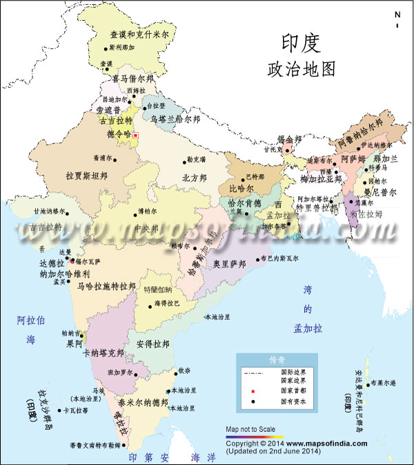
India, officially known as the Republic of India, is a diverse country, consisting of 29 states and 7 union territories. Bordered by plain land, mountains, desert and three oceans, India is a small world in itself. A glance through the India Political map would give users an idea about the geographical location and area of the various states of the country and their territorial boundaries. The map also depicts its states and their capitals, state boundaries, international borders and major cities of the country. Exploring the political map of India is a nice way to know more about the country.
| Maps and Information on States & Union Territories |
| States |
Capital |
| Andhra Pradesh |
Hyderabad |
| Arunachal Pradesh |
Itanagar |
| Asom (Assam) |
Dispur |
| Bihar |
Patna |
| Chhattisgarh |
Raipur |
| Goa |
Panaji |
| Gujarat |
Gandhinagar |
| Haryana |
Chandigarh |
| Himachal Pradesh |
Shimla |
| Jammu And Kashmir |
Jammu, Srinagar |
| Jharkhand |
Ranchi |
| Karnataka |
Bengaluru (Bangalore) |
| Kerala |
Thiruananthapuram (Trivandrum) |
| Madhya Pradesh |
Bhopal |
| Maharashtra |
Mumbai |
| Manipur |
Imphal |
| Meghalaya |
Shillong |
| Mizoram |
Aizawl |
| Nagaland |
Kohima |
| Odisha (Orrisa) |
Bhubaneshwar |
| Punjab |
Chandigarh |
| Rajasthan |
Jaipur |
| Sikkim |
Gangtok |
| Tamilnadu |
Chennai |
| Telangana |
Hyderabad |
| Tripura |
Agartala |
| Uttar Pradesh |
Lucknow |
| Uttarakhand (Uttaranchal) |
Dehradun |
| West Bengal |
Kolkata |
| Union Territories |
Capital |
| Andaman and Nicobar |
Port Blair |
| Chandigarh |
Chandigarh |
| Dadra and Nagar Haveli |
Silvassa |
| Daman and Diu |
Daman |
| Delhi |
Delhi |
| Lakshadweep |
Kavaratti |
| Puducherry |
Puducherry |
