The country is home to a widespread network of harbors and inland watercourses. The inland watercourses of the country comprise canals, rivers, creeks, and backwaters.
The overall navigable span of the inland watercourses in India is 14,500 km. The legal authority in control of the watercourses in the country is the Inland Waterways Authority of India or IWAI.
The national watercourses in India can be divided into three and they are as follows:
- The Brahmaputra river system - extending from Sadiya to Dhubri
- The Ganga Bhagirathi Hooghly river - extending from Allahabad in Uttar Pradesh to Haldia in West Bengal
- The West Coast Canal from Kottapuram to Kollam together with Udyogmandal canal and Champakara canal.
Haldia, Kolkata, Visakhapatanam, Paradip, Chennai, Ennore, Cochin, Tuticorin, Mormugao, New Mangalore, Mumbai, Jawaharlal Nehru Port Trust, and Kandla.
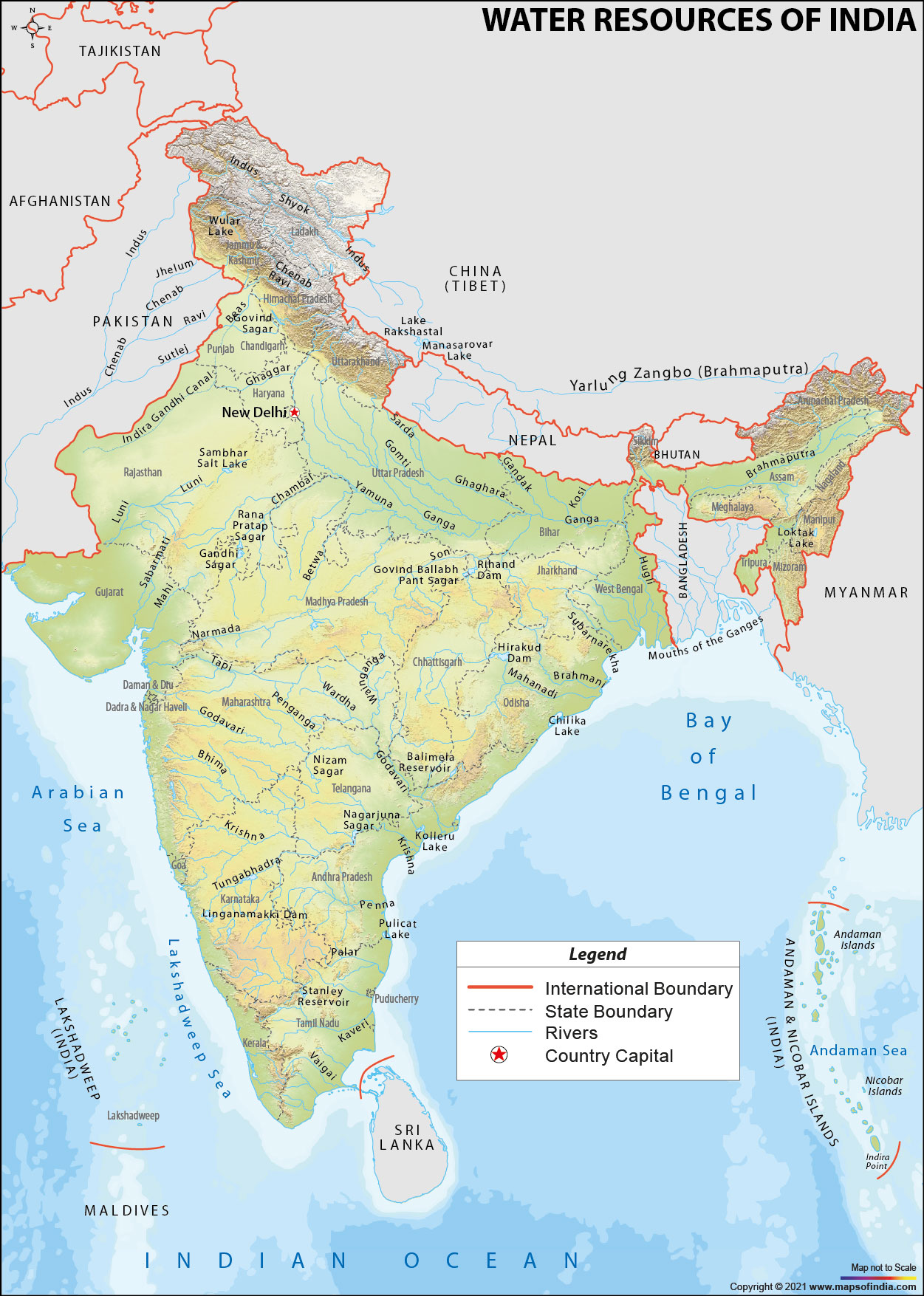
Rivers in India
The country houses 12 rivers that are categorized as important rivers. The overall drainage basin watered by these rivers is more than 976,000 sq miles or 2,528,000 km2.
All the important rivers in the country have their sources in any of the following areas:
- Vindhya and Satpura mountain range, forming a part of the heart of the country
- The Karakoram and Himalayan mountain ranges
- Sahyadri or Western Ghats mountain range, forming a part of western India
The source of the Ganges river is the Gangotri Glacier, which lies in the state of Uttarakhand . Subsequently, the river runs in the southeast direction, before pouring into the Bay of Bengal. The headwaters of the Gomti and Yamuna rivers lie in the western part of the Himalayan mountain range. These two rivers meet the Ganga in the flat terrain.
The Brahmaputra River has its headwaters in the territory of Tibet. In the province of Tibet, people call it "Tsangpo" or Yarlung Tsangpo River. The river then penetrates the Indian Territory via the state of Arunachal Pradesh in the Northeast. Subsequently, the river moves to the west into Assam. In Bangladesh, the river meets the holy Ganga and the name of the river changes to the Jamuna River.
A major branch of the river Ganga (Yamuna) is the Chambal River. The river has its headwaters in the Satpura and Vindhya mountain ranges. It runs to the east. From the same source, other rivers that have originated include the Tapti and Narmada and both of these rivers pour into the Arabian Sea in the west. The river system that runs from the east to west forms 10% of the overall outpouring of water in India.
All the rivers of the Deccan plateau have their headwaters in the Western Ghats mountain range. These rivers include the Godavari River, the Mahanadi River (passing across the delta formed by itself), Kaveri River, and Krishna River. All these rivers ultimately pour into the Bay of Bengal. Approximately 20% of the overall outpouring of the country is represented by these rivers.
The intense precipitation in the rainy season in the southwest results in the swelling of the banks of the Brahmaputra and other rivers in India. This frequently leads to inundating of the bordering regions. Despite the fact that these rivers work as a fundamentally reliable source of fertilization and natural supply for the paddy cultivators, these inundations have resulted in loss of lives of a large number of people and force the population of the area to move to other places.
Capes in India
The major capes in India are as follows - Indira Point, the southernmost tip in India which is situated on the Great Nicobar Island, the Kanyakumari, the southern point of territory of India., Point Calimere, and Adam's (Rama's) Bridge.
Gulfs in India
The important gulfs in India are the Gulf of Kutch, the Gulf of Cambay, and the Gulf of Mannar. The country houses straits like the Ten Degree Canal, which dissevers the Andamans from the Nicobar Islands, the Palk Strait, which splits India from Sri Lanka, and the Eight Degree Canal, dissevering the Lakshadweep and Amindivi Islands from the Minicoy Island in the south.
The Indian Ocean and the Bay of Bengal are situated towards the south and east of the country and the Arabian Sea is located in the west. The Andaman Sea and the Lakshadweep Sea are smaller water bodies. The country houses four coral reefs and they lie in the Gulf of Mannar, the Andaman and Nicobar Islands, the Gulf of Kutch, and the Lakshadweep Islands.
Lakes in India
The major lakes in India are as follows - Vembanad Lake (Kerala), Sambhar Lake, (the biggest saltwater lagoon of the nation in Rajasthan ), Loktak Lake (Manipur), Kolleru Lake (Andhra Pradesh), Chilka Lake (Orissa), Dal Lake (Kashmir), and Sasthamkotta Lake (Kerala).
Water bodies that border India
Given below are the names of the water bodies that surround India from different sides:
- Lakshadweep Sea in the southwest
- Arabian Sea in the west
- Bay of Bengal in the east
- Indian Ocean in the south
Last Updated on March 30, 2026