


A world map projection is a method used to represent the Earth's curved surface on a flat map. The Earth is nearly spherical, but a map is a flat surface; it is impossible to take the surface of the Earth and copy it onto a flat surface without some distortion. This means that the size and shape of countries or continents can vary by projection. Thus, countries and continents can be of varying size and shape depending on the map projection used. Several world map projections have been developed to maintain specific geographical characteristics or to find a useful compromise among the various types of distortion. Understanding these projections helps explain why world maps can look so different and why no single map projection is ideal for every purpose.
What Is a World Map Projection?
A map projection is a mathematical technique used to transform points on the curved surface of the Earth to points on a flat map. It is a systematic method for depicting geographic coordinates (latitude and longitude) on a 2D plane. All projections have some compromise, as the spherical surface of the Earth cannot be perfectly flattened.
Why Is a Map Projection Needed?
While the Earth is in the shape of a globe, most maps, computer screens and digital mapping systems are flat. A projection provides the mathematical framework needed to transfer geographic information from the globe to that flat surface.
Maps serve different purposes, which is why there are different projections. Depending on the map, a navigation map might want to show direction, and a map of global population or land mass might want to show areas more accurately. Therefore, choosing a map projection depends largely on what information the map is intended to communicate.
What Can Be Distorted on a World Map?
When the surface of the Earth is represented on a flat map, its surface can be distorted in 4 ways.
- Area: The relative size of countries or continents can be changed.
- Shape: The landmasses can be stretched, compressed or changed in other ways.
- Distance: The distance measured on a map could be different from one position to another.
- Direction: The angle or bearing between places may not remain accurate everywhere.
Types of World Map Projections
Map projections can be classified in several ways. A common introductory classification is based on the geometric surface used in construction: cylindrical, conic and azimuthal (planar) projections. Other projections, such as pseudocylindrical and compromise projections, have been categorized based on their mathematical properties and construction.
Cylindrical Projections
In a cylindrical projection, the surface of the Earth is conceptually projected on a cylinder that is then "unrolled" to form a flat map. It is commonly known that a cylindrical projection is used in maps that encompass a large area, such as the whole world.
Examples include the Mercator projection, Equirectangular projection and Gall-Peters projection. Latitude and longitude can be represented in convenient ways on cylindrical projections, but some are quite distorted, especially near the poles.
Some projections, such as the Mercator projection, distort areas at high latitudes. Equal-area cylindrical projections such as Gall-Peters instead prioritize the accurate representation of relative land area.
Conic Projections
Conic projections are the most important of all types of projections because they project the Earth's surface onto a cone. If the cone is unrolled, it forms a flat map. Useful in regional maps, particularly those covering the middle latitudes predominantly, but not in displaying the whole world.
Some of the notable examples are Albers Equal-Area and Lambert Conformal Conic. Albers Equal-Area preserves the relative area of places and is suitable for thematic maps or statistical maps; Lambert Conformal Conic emphasizes local shapes and angles.
Azimuthal Projections
Azimuthal projections are those in which the Earth's surface is displayed on a flat plane that is placed against or cuts across the globe. They are very helpful in maps with a particular focus, that is, on a hemisphere or a polar region.
These include projections like Orthographic, Azimuthal Equidistant and Lambert Azimuthal Equal-Area projections. They can store specific distances, directions or areas from the center/around certain areas based on type.
Major World Map Projections
Several projections have become particularly important in cartography and geographic visualization. Each offers a different way of solving the problem of mapping the curved surface of the Earth onto a flat surface.
Mercator Projection
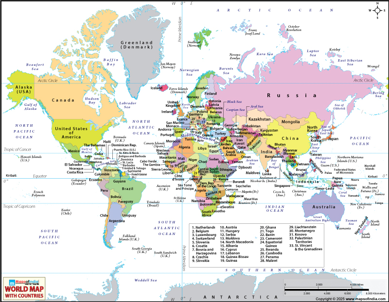
One of the most commonly used maps of the world is the Mercator projection. It is a cylindrical conformal projection, meaning that local angles are preserved, and that rhumb lines (lines of constant compass angle) are preserved as straight lines, which for historical reasons was useful for navigation. The historic value of the Mercator projection was that straight rhumb lines on the map represented constant compass bearings.
But its area distortion is large near the poles. Thus, high-latitude regions may look much bigger than they really are. Greenland is a well-known example of this effect.
Gall-Peters Projection
The Gall-Peters projection is a cylindrical map that is equal-area. The main advantage is that it maintains the proportions of the areas of countries and continents. This can be helpful if the intent of the map is to show the relative area of geographic regions.
The compromise is that they will be distorted in shape quite a bit. Countries can appear unusually elongated or compressed, particularly in certain parts of the world. Thus, while areas are represented proportionally, the shapes may look less familiar than on other world maps.
Robinson Projection
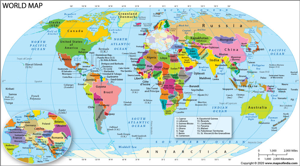
The Robinson projection is a compromise projection designed to give a balanced look to the world as a whole. Instead of maintaining a uniform geographic characteristic, it minimizes a number of types of distortion.
It was popular for use on general-purpose world maps and atlases, due to its roundness and relatively even treatment of continents. The Robinson projection is not perfect in terms of area, shape, distance, or direction, but is a means of meeting the needs of the visual display.
Winkel Tripel Projection
The Winkel Tripel projection is another compromise projection that minimizes the total distortion on a world map. It tries to compensate for the distortions of area, shape and distance and direction, but does not take particular account of any one of these properties.
It has a relatively even appearance and is good for general world reference maps. It is also linked to contemporary maps of the world, in the form of atlases.
Equal Earth Projection
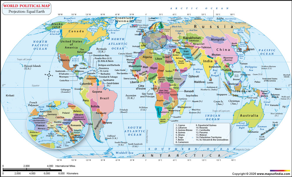
The Equal Earth projection is a new equal-area map projection used to show the relative areas of the world's continents and countries in the same proportions as they would appear if they were on a flat plane.
Because it preserves area, it is particularly useful for global thematic maps showing subjects such as population, climate, agriculture and environmental patterns. It provides an alternative to older equal-area projections while reducing some of the visual distortion associated with them.
What Happened in 2026?
In 2026, world map projections received renewed global attention after the United Nations General Assembly endorsed a resolution encouraging the use of equal-area world map projections, including Equal Earth, when accurately showing the relative size of countries and continents is important. The move highlighted concerns about the area distortion of the widely used Mercator projection, which makes high-latitude regions such as Greenland appear much larger than they are. The resolution does not ban Mercator or require a single projection; instead, it encourages greater consideration of equal-area maps for appropriate uses.
The development reinforced an important cartographic principle: there is no single perfect world map projection. Different projections prioritize different properties, including area, shape, distance and direction, depending on their intended purpose.
World Map Projection Comparison
Different projections are suited to different mapping requirements. The following comparison summarizes their main characteristics:
| Projection | Main Strength | Main Limitation | Common Use |
|---|---|---|---|
| Mercator | Direction and local angles | Strong area distortion | Navigation |
| Gall-Peters | Relative area | Shape distortion | Area comparison |
| Robinson | Overall visual balance | Does not preserve one property perfectly | General world maps |
| Winkel Tripel | Reduced overall distortion | No single property is perfectly preserved | World reference maps |
| Equal Earth | Accurate relative area | Some shape and distance distortion | Global thematic maps |
| Mollweide | Equal-area representation | Shape distortion | Global data maps |
Which Properties Do Different Projections Preserve?
Map projections are often described according to the geographic properties they preserve. Equal-area projections preserve the relative area of geographic regions. Conformal projections maintain local angles and shapes, but may suffer from distortion of area. Equidistant projections maintain some of the distances, typically from a set of points and/or along a set of lines. Some types of azimuthal projections show direction from the central point, and some are designed to show area, distance or other properties.
Knowing these terms helps to explain why two maps of the same world appear to be quite different.
How Do World Map Projections Distort the Earth?
No flat map projection can keep all of area, shape, distance, and direction the same, all over the map. The nature of the distortion is determined by the mathematics of the projection, as well as the point of projection.
Area Distortion
Area distortion alters the perception of relative areas. For instance, on a Mercator map, the poles seem larger than they really are. It can be avoided by using equal-area projections.
Shape and Distance Distortion
Continents or countries change shape due to stretching or compression. Distance can also become inaccurate, particularly distances between points far removed from the areas of greatest accuracy of the projection used.
Direction Distortion
When it comes to navigation, direction is of special significance. Some projections are intended to maintain the local angles or bearings, whilst others are compromising on directional accuracy to satisfy a requirement for area or visual balance throughout the projection.
Why Does Greenland Look So Large on Some World Maps?
From the perspective of a high Northern latitude, Greenland can seem quite large on many maps that are familiar to most. The Mercator projection makes the polar regions appear larger than they are. On the map, Greenland appears far greater than it is on an equal-area map. In reality, Africa is vastly larger than Greenland. An equal-area projection provides a more proportional representation of their relative sizes. This difference demonstrates why the apparent size of a country or continent on a world map should not automatically be interpreted as its actual geographic area.
How World Map Projections Are Used
World map projections are selected according to the purpose of a map and the geographic information it needs to communicate.
World Map Projections in Navigation
Navigation has been an important application of projections like Mercator in the past. It preserves the correct angle and compass bearings, making it suitable for use in plotting some navigation courses.
World Map Projections in Education and Atlases
A common issue with world maps presented in classrooms and in atlases is that they tend to favour projections that present a balanced look of the continents. Examples of general geographic reference projections include Robinson and Winkel Tripel.
World Map Projections in GIS and Data Mapping
There are various projections used for Geographic Information Systems (GIS) depending on the geographic area and type of analysis. Population, land use, climate, agriculture, environmental conditions, and other spatial datasets can be selected for projections to be used for mapping.
World Map Projections in Digital Maps
Digital mapping systems also rely on projections to display geographic information on computer screens and other devices. For instance, many online map services, such as Google Maps, use Web Mercator or a close variant because of their efficiency for interactive maps and tiled web mapping. The type of projection used will vary with the size, area and function of a map.
How to Read and Understand a World Map Projection?
Reading a world map isn't just about seeing the relative size and shape of countries. The projection that's being used should always be taken into account.
Look at the Equator and Poles
Check how the projection represents areas at different latitudes. Many cylindrical (non-conic) world map projections show distortion that is more noticeable toward the poles.
Compare the Size of Continents
Comparing familiar landmasses may help to identify distortion in the area. Examples of areas that appear to have vastly different sizes between projections are good for Africa, Greenland and South America.
Check Shape, Distance and Direction
Consider whether the map is designed to preserve area, shape, distance or direction. An exact representation of one property can include the deliberate distortion of another.
Understand the Purpose of the Map
It's best to know the reason for a projection. A navigation map, an atlas, a climate map and a population map may all use different projections because each has different requirements.
Finally, there is no ideal world map projection. Each projection has its own character in terms of its geographic accuracy, visual appeal, and intended uses. Moreover, these differences help one to read the world map correctly and to understand that the geography of the Earth can appear different in projections.
FAQs
Q1: What is a world map projection?
A world map projection is a mathematical method used to represent the Earth's curved surface on a flat map. Different projections preserve different properties, such as area, shape, distance or direction.
Q2: Why are there different types of world map projections?
Different world map projections are created for different purposes. Since no flat map can accurately preserve area, shape, distance and direction everywhere, each projection makes specific compromises depending on its intended use.
Q3: What is the Mercator projection?
The Mercator projection is a cylindrical, conformal map projection originally developed for navigation. It preserves local angles and represents constant compass bearings as straight lines, but significantly enlarges areas near the poles.
Q4: Why does Greenland look bigger than Africa on some world maps?
Greenland looks disproportionately large on maps using the Mercator projection because area distortion increases toward the poles. In reality, Africa is about 14 times larger than Greenland.
Q5: What is the Equal Earth projection?
The Equal Earth projection is an equal-area world map projection designed to show countries and continents according to their relative land areas. It provides a more proportional representation of global landmass while maintaining a visually balanced appearance.
Q6: Which world map projection is the most accurate?
There is no single most accurate world map projection for every purpose. Equal-area projections are best when comparing land areas, Mercator is useful for navigation, and compromise projections such as Robinson and Winkel Tripel are designed for balanced general-purpose world maps.
Q7: What happened to world map projections in 2026?
In 2026, world map projections gained renewed attention after the United Nations General Assembly endorsed a resolution supporting greater use of equal-area world maps, including Equal Earth, when accurately representing the relative size of countries and continents is important. The resolution does not ban the Mercator projection.
Last Updated on: September 10, 2026


