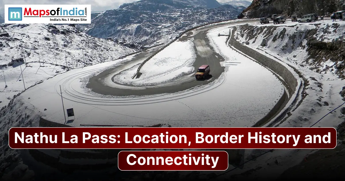
Nathu La Pass is a Himalayan mountain pass on the Sikkim-Tibet border that connects India with China's Tibet Autonomous Region. Located at 4,310 m in the Dongkya Range, it is one of the few designated trading points on the entire Sino-Indian border. It was a Silk Route artery and is now a working crossing for both border trade and the Kailash Mansarovar Yatra. This article covers where Nathu La is, its role in trade history, its place in the 1962 and 1967 India-China border conflicts, and what the pass is like today for traders, pilgrims and tourists.
What Is Nathu La Pass?
Nathu La gets its name from Tibetan. "Nathu" means "listening ears" and "La" means "pass," though it is also sometimes called "the whistling pass " because of the wind that passes through the gap. It is located among the passes of the Himalayas Dongkya Range, roughly 4 km north of the slightly higher Jelep La, which was the preferred trade route before Nathu La became more prominent in the 20th century.
Where Is Nathu La Located?
Position on the Sikkim-Tibet border
Nathu La is directly on the boundary between Sikkim and the Tibet Autonomous Region at the point where the Dongkya Range forms a natural saddle that leads into the Chumbi Valley. Indian and Chinese troops stationed here are among the closest of any point along the 4,000 km Sino-Indian border. Sometimes as little as 20–30 metres apart.
Altitude and terrain
The pass itself is at 4,310 m (14,140 ft), with the surrounding Dongkya Range terrain featuring barren high-altitude slopes, thin air, and weather that changes quickly even within a single day.
Distance and route from Gangtok
Nathu La is 54–56 km east of Gangtok, reached via a mountain road that climbs through Tsomgo (Changu) Lake and the Sherathang trade mart before reaching the pass itself. A route that gains roughly 3,700 metres of elevation over the course of the drive.
Nathu La and the Old Silk Route
Historic trade between Sikkim, Tibet and Bengal
Long before it became a flashpoint, Nathu La served as a working trade artery linking Tibet, Sikkim and British Bengal. British explorer J. Ware Edgar recorded trade running through the pass as early as the 1870s, connecting onward to Gangtok and Darjeeling, though he personally preferred the nearby Jelep La for its gentler gradient.
Goods and trading communities along the route
In the 1950s, more than a thousand mules and hundreds of traders regularly crossed the pass carrying wool, salt and other goods between Tibet and the Indian plains. A scale of activity that gives some sense of how central this crossing once was to the regional economy long before formal national borders hardened around it.
Why this pass mattered in the age of caravans
With no rail or air links into this part of the Himalayas until the 20th century, Nathu La and its neighbouring passes were simply how goods, pilgrims, and dignitaries crossed between Tibet and the Indian subcontinent. It functioned less as a border in the modern sense and more as a mountain gateway between two interconnected trading regions.
Nathu La Border History
Colonial-era and 20th-century context
Sikkim became a British protectorate under the 1861 Treaty of Tumlong, after which the British actively promoted trade through Sikkim's Himalayan passes, including Nathu La. Through the 20th century, with no alternative transport infrastructure in the region, the pass remained a genuine international crossing used by traders, explorers, and officials.
Closure of the pass after 1962
That changed with the 1962 Sino-Indian War. India sealed Nathu La in its aftermath, cutting off a route that had functioned continuously for generations and turning what had been a trading post into a heavily militarised frontier.
The 1967 Nathu La clashes and why they are remembered
Five years later, tensions boiled over again. Between 11–14 September 1967, Indian and Chinese forces exchanged artillery and automatic weapons fire at Nathu La, followed by a smaller clash at nearby Cho La on 1 October. Often referred to as the Nathu La and Cho La clashes, this remains the most serious military confrontation between India and China in the years following the 1962 war. Indian forces held their ground at both locations, and Chinese troops ultimately withdrew from the contested positions.
Reopening and the evolution of the border arrangement
Sikkim formally joined India in 1975. Nathu La became fully Indian territory. It would take until 2003. China's formal acknowledgement of Sikkim as part of India came before the two countries signed a border-trade memorandum of understanding. Paving the way for Nathu La to reopen for limited trade on 6 July 2006, the first such reopening anywhere on the India-China border since 1962.
Nathu La as an India-China Trade Route
Reopening of border trade in 2006
When trade resumed in 2006, it marked a symbolic moment. A Cold War–era closure finally gave way to limited commerce along one of the historic Silk Route's old branches. In the 2006 season, Tibet's regional Bureau of Commerce recorded roughly US $186,250 worth of trade passing through the pass over 51 trading days.
Trade mart at Sherathang and the items traded
Trade activity is centred on Sherathang, a designated customs and excise post on the side near Nathu La, with Rinchengang serving as its Chinese counterpart. Over the years, the mart has also become notable for hosting India's altitude permanent power substation and internet café, both operating at roughly 13,600 feet.
Current status of trade
Border trade through Nathu La was suspended in 2020 amid the COVID-19 pandemic and the broader deterioration in India-China relations following the Galwan Valley clash. Following talks, including Chinese Foreign Minister Wang Yi's 2025 visit to New Delhi, India and China agreed to reopen all three designated trading points. Nathu La trade formally resumed on 1 August 2026 after a six-year suspension, alongside Shipki La in Himachal Pradesh. As with seasons, trade through Nathu La runs only during the warmer months, typically restricted to 7–8 months a year due to heavy winter snowfall.
Connectivity: Roads, Access and Strategic Importance
The Jawaharlal Nehru Road and the route from Gangtok
The road connecting Gangtok to Nathu La, often referred to locally in connection with the Jawaharlal Nehru Marg, is one of Sikkim's strategically important stretches of highway maintained year-round by the Border Roads Organisation, given its dual civilian and military significance.
Logistical importance for India
Because Indian and Chinese positions sit so close together here, Nathu La remains one of the most closely watched and heavily garrisoned points on the entire Sino-Indian frontier, with road connectivity treated as a strategic priority independent of its trade or tourism value.
Role in connectivity and Sikkim's economy
Beyond its military significance, the pass and the road leading to it support a meaningful share of East Sikkim's tourism economy, with Tsomgo Lake and the approach to Nathu La ranking among the state's most-visited attractions, alongside whatever economic activity trade seasons bring to border communities.
Kailash Mansarovar Yatra Through Nathu La
Nathu La has, since 2015, served as a route for the Kailash Mansarovar Yatra, offering pilgrims a motorable approach to the Tibetan plateau as an alternative to the more physically demanding Lipulekh Pass route in Uttarakhand. Like border trade, the Yatra was suspended for years following the pandemic and border tensions. It resumed through Nathu La in June 2026, organised by India's Ministry of External Affairs, with pilgrim groups travelling in batches as part of a 2026 revival that also reopened the Lipulekh route. Given how closely tied the Yatra schedule is to the state of India-China relations, pilgrims should always confirm the registration windows and route status directly through the Ministry of External Affairs before planning travel.
Visiting Nathu La: Permits, Timings and Best Time to Go
Permit requirements
Indian citizens need a Protected Area Permit to visit Nathu La, typically arranged through registered travel agents in Gangtok, along with photo identification. Foreign nationals are generally not permitted beyond Tsomgo Lake. Cannot proceed to Nathu La itself given the pass-sensitive border location. A restriction worth confirming directly with Sikkim Tourism, since access rules for border areas can change.
Days and hours the pass is open to visitors.
Nathu La is typically closed to tourists on Mondays and Tuesdays, with visiting hours limited to the late morning and early afternoon; exact days and timings should be verified with local authorities or tour operators before travel, as schedules are set locally and subject to change.
Best season, weather and altitude precautions
May to October generally offers reliable access, avoiding the heaviest winter snowfall that can close the route entirely. Given the altitude, visitors are commonly advised to acclimatise for a day in Gangtok, stay hydrated, and travel with warm layers regardless of season, since conditions at 4,310 m can shift rapidly.
What to see nearby
A typical trip to Nathu La is usually combined with stops at Tsomgo (Changu) Lake, a lake roughly 40 km from Gangtok; the Baba Harbhajan Singh Mandir, a memorial shrine to an Indian Army soldier revered by troops stationed in the area; and Kupup, a small high-altitude settlement near the Old Baba Mandir and the scenic Elephant Lake.
Conclusion
Nathu La's story starts with a working Silk Route artery that went through four decades of Cold War–era closure and is now a renewed, managed border crossing. This place now handles both trade shipments and pilgrim convoys heading toward Kailash. Its location, pressed up against one of the most sensitive stretches of the Sino-Indian border, means its status has always moved in step with the wider relationship between India and China, and that's likely to remain true going forward.
FAQs
Where is Nathu La Pass located?
Nathu La is located in East Sikkim, India, roughly 54 km east of Gangtok on the international border with China's Tibet Autonomous Region.
What does Nathu La mean?
"Nathu" means "listening ears" and "La" means "pass" in Tibetan, though the name is also sometimes translated loosely as "the whistling pass," a likely reference to the wind through the gap.
How high is Nathu La?
Nathu La sits at 4,310 metres (14,140 feet) above sea level in the Dongkya Range of the Himalayas.
How far is Nathu La from Gangtok?
Nathu La is approximately 54–56 km from Gangtok, a drive that typically takes 3 to 4 hours one way via Tsomgo Lake.
Why is Nathu La important to India and China?
It's one of three officially designated India-China border-trade points, a historically significant Silk Route crossing, a sanctioned Kailash Mansarovar Yatra route, and a strategically sensitive military frontier where troops from both countries are stationed unusually close together.
Is Nathu La open for trade?
Yes, as of August 2026, following a six-year suspension since 2020. Trade operates seasonally for 7–8 months of the year, and its status has historically depended closely on the broader state of India-China relations.
Can tourists visit Nathu La?
Indian citizens can visit with a Protected Area Permit arranged through a registered Gangtok travel agent; foreign nationals are generally restricted to Tsomgo Lake. Not permitted to proceed to the pass itself.
Is Nathu La part of the Kailash Mansarovar Yatra route?
Yes. Nathu La has served as one of two government-organised routes since 2015 alongside the Lipulekh Pass route, in Uttarakhand, with both routes resuming in 2025–26 after a pandemic-era suspension.