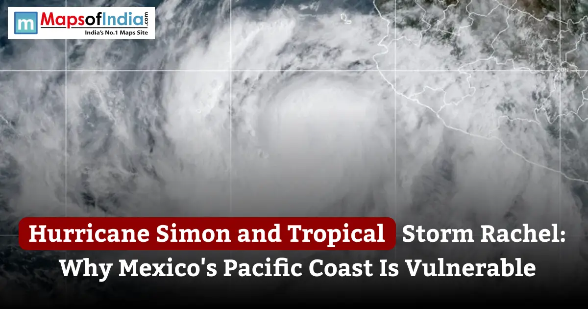
Hurricane Simon's impacts on Mexico and Tropical Storm Rachel’s passage across Baja California show why the country’s Pacific coast is vulnerable to storms, torrential rain and flooding. As of October 13, Simon has weakened from its major-hurricane intensity while Rachel has become post-tropical after moving over Baja California. Both systems caused impacts, although Simon’s centre remained offshore rather than making landfall. The storms affected parts of Mexico over the same period, exposing coastal communities to overlapping weather threats. This article explains their tracks and intensity, the areas the hazards they produced and the roles of warm ocean waters, El Niño, mountainous terrain and coastal development in shaping Mexico’s hurricane risk.
What Happened: Hurricane Simon and Tropical Storm Rachel at a Glance
Hurricane Simon and Tropical Storm Rachel affected Mexico’s Pacific side during the weekend of October 2026. Simon strengthened rapidly over the Pacific before moving close to western Mexico, while Rachel travelled toward the Baja California Peninsula and crossed into its post-tropical phase. Their combined effects included flooding, dangerous surf, infrastructure disruption and damage to communities. "Mexico’s National Water Commission (CONAGUA)" issued updates as the systems approached and affected the country.
Hurricane Simon: Track, Intensity and Landfall
Hurricane Simon formed as a storm on October 7, 2026, off Mexico’s southwestern coast. It intensified rapidly, reaching Category 4 on the Saffir–Simpson Hurricane Wind Scale on October 10. On October 11, Mexico’s weather authorities reported Simon near the coast of Jalisco with strong winds, extraordinary rainfall forecasts and hazardous waves.
An important distinction: Simon did not make landfall along the Jalisco–Colima coast in the reporting on October 13. Its centre moved parallel to or just offshore from parts of Mexico. Without a direct landfall, hurricane-force winds, outer rainbands, high waves and prolonged rainfall can cause serious impacts on land. By October 12, it was reported that Simon had weakened to Category 2 while continuing to threaten Mexico with flooding and mudslides.
Tropical Storm Rachel: Baja California and the US Border Region
Rachel followed a path toward Baja California in northwestern Mexico. By October 10, Mexico’s authorities classified it as a tropical cyclone as it approached the peninsula. Early on October 11, its centre was reported on land around 40 kilometres from Ensenada, Baja California, with sustained winds of approximately 95 km/h.
Although Rachel was no longer classified as a cyclone when it moved over land, its remaining circulation still carried strong winds, heavy rain and dangerous coastal conditions. Its impacts extended toward the US border region, where moisture associated with the system contributed to flooding concerns in Southern California and other parts of the United States.
Why Two Storms Struck at Once
Simon and Rachel were weather systems, not one storm splitting into two. Simon developed over the Pacific near southwestern Mexico while Rachel moved toward Baja California farther north. Their paths overlapped in time, bringing parts of the country under storm-related alerts during the same period.
The occurrence of two systems together does not mean they shared the track or produced identical conditions. Their effects depended on their strength, speed, distance from land and local geography. Simon threatened west-central Mexico with rainfall and high surf while Rachel’s remnants brought wind and rain to Baja California and parts of the US Southwest.
Where Are Simon and Rachel Hitting?
The two systems affected coastal regions. Simon’s main areas of concern were along Mexico, while Rachel’s impacts were concentrated in Baja California and extended northward toward the United States.
Jalisco, Colima and Michoacán (Simon)
Jalisco and Colima were among the states most exposed to Simon’s passage. Authorities warned of rainfall in parts of Jalisco, torrential rain in Colima and intense rainfall in portions of neighbouring states. Michoacán also faced rain and coastal hazards.
Key places and coastal features include:
- Puerto Vallarta, Jalisco: A tourism destination exposed to heavy rain, rough seas and disruptions to transport and outdoor activities.
- Manzanillo, Colima: An important Pacific port city where flooding and hazardous coastal conditions can affect residents, shipping and logistics.
- Cabo Corrientes, Jalisco: A coastal area near Simon’s reported path exposed to high surf and strong winds.
These locations faced levels of risk depending on their proximity to the storm, local rainfall and coastal conditions. A city’s mention in a storm report does not automatically mean that its entire area experienced hurricane-force winds.
Baja California and Baja California Sur (Rachel)
Rachel’s path brought the concern to the Baja California Peninsula. Ensenada and nearby communities faced winds, heavy rain and rough seas as the system moved over the region. Tijuana, Tecate and Rosarito are also relevant to monitoring because of their location in northern Baja California, although conditions can vary considerably from one municipality to another.
Baja California Sur, south of the peninsula, was also included in coastal weather advisories during Rachel’s approach. The storm’s post-tropical status did not eliminate the danger: a system can retain winds and produce hazardous rain and waves after it loses tropical characteristics.
Spillover Effects: US Moisture and Surf
Rachel’s remnants also contributed to heavy rain and flooding concerns in the southwestern United States. Reports on October 13 described flooding in parts of Southern California and Nevada associated with the storm’s moisture. The effects of a system can extend far beyond its centre, particularly when moisture interacts with other weather patterns.
For communities, the main concerns included dangerous surf, rip currents, localised flooding and disruption to roads or public facilities. Residents should rely on local alerts rather than assume that conditions are safe once a storm moves away.
What Are the Main Hazards from Hurricane Simon and Rachel?
The main hazards from Hurricane Simon and Rachel included rain, flooding, strong winds, dangerous waves and travel disruption. The specific threat varied by location and by each system’s stage of development.
Torrential Rain, Flash Floods and Mudslides
Heavy rainfall can become dangerous when it falls faster than soil, streams and drainage systems can absorb or carry it away. On October 11, CONAGUA forecast rainfall exceeding 250 millimetres in parts of Jalisco, with very heavy to torrential rainfall expected in other affected states. These were forecast ranges, not confirmed measurements of rainfall that had already occurred.
Rapid runoff can flood streets, overwhelm drainage channels and raise river levels. On slopes, saturated soil can also trigger landslides and mudslides. Flooding may continue after the strongest winds have weakened, so the end of a hurricane warning does not necessarily mean that all hazards have passed.
Storm Surge and Dangerous Waves
Strong winds push seawater toward the coast, potentially raising water levels above tides. This is known as storm surge. Large waves can also cause erosion, damage exposed structures and make beaches, harbours and waterfront areas unsafe.
Authorities reported waves and the risk of storm surge along parts of the Jalisco and Colima coasts during Simon’s approach. Rachel also brought seas and high waves to the Baja California region. The greatest local risk depends on shoreline shape, water depth, tide timing and the storm’s position.
Wind Damage in a Compact Hurricane’s Core
A hurricane can concentrate very strong winds close to its centre. Its strongest winds may affect a limited area, but buildings, trees, power lines and transport infrastructure within that zone can still be damaged.
Simon reached Category 4 intensity, with Mexico’s authorities reporting sustained winds of 250 km/h in an advisory on October 11. Its intensity later decreased. Hurricane categories describe wind strength, however. Do not fully capture a storm’s rainfall, flood risk or total impact.
Disruption to Ports, Flights and Tourism
Storms can interrupt airport operations, port activity, road travel, ferry services and tourism. Strong winds and heavy rain may force authorities or operators to suspend services, while rough seas can affect fishing and maritime activity.
Puerto Vallarta and other coastal destinations depend on transport links and outdoor tourism. Manzanillo is particularly important because of its port and associated freight activity. Rachel’s effects also created travel and safety concerns around Ensenada and the US border region. Travellers should confirm the status of flights, hotels, roads and port services with the relevant operators.
Why Is Mexico’s Pacific Coast So Vulnerable to Hurricanes?
Mexico’s Pacific coast is vulnerable because tropical cyclones can develop over ocean waters near the country, move close to populated shorelines and bring heavy rainfall to steep terrain. Coastal settlements, ports, tourism infrastructure and communities with drainage capacity can face several hazards at the same time.
Warm Ocean Waters and Rapid Intensification
Tropical cyclones draw energy from ocean water and the transfer of heat and moisture from the sea to the atmosphere. When ocean conditions are favourable, and other atmospheric factors align, a tropical storm can strengthen quickly. Simon’s rapid intensification into a hurricane illustrates how quickly a forecast can change when conditions support development.
Warm water alone does not guarantee that a storm will intensify. Wind shear, moisture, air pressure patterns and the storm’s internal structure also matter. Rapid intensification is particularly challenging for emergency planners because the time available to prepare may be shorter than expected.
The Role of El Niño in a Busy Pacific Season
El Niño changes ocean temperatures and atmospheric circulation across the Pacific. In some years, it creates conditions that favour activity in the eastern and central Pacific hurricane basins, including through changes in vertical wind shear. The effect varies by season. El Niño does not determine the track or strength of every individual storm.
Reporting published on October 12 described the 2026 eastern and central Pacific season as active, with El Niño and warmer ocean conditions among the factors under discussion. Researchers distinguish between conditions that make storms more likely and the specific causes of an individual hurricane’s behaviour.
Steep Mountains Close to the Coast
The Sierra Madre mountain ranges rise near sections of Mexico’s Pacific shoreline. When moist air is pushed inland and upward, it can enhance rainfall over slopes. Water then runs downhill into valleys, streams and coastal settlements.
This terrain can turn tropical rainfall into a major flood and landslide threat. Narrow valleys and steep watersheds may respond quickly to rain while rivers can carry water and debris toward low-lying areas. The danger can extend inland when a hurricane’s centre remains offshore.
Dense Coastal Populations, Ports and Tourism Hubs
Mexico’s Pacific coast contains cities, resort destinations, fishing communities, industrial sites and transport infrastructure. Puerto Vallarta attracts international visitors while Manzanillo is a key port. Coastal settlements may face wind, rain, wave and flood risks simultaneously.
The concentration of people and assets means that even a storm that does not make direct landfall can disrupt life and economic activity. Tourism and port operations are especially sensitive to transport closures, rough seas and power or road interruptions.
Storm Tracks That Parallel or Curve Toward the Coast
Eastern Pacific storms often form south of Mexico and may move westward, northwestward, or northward depending on the atmospheric steering pattern. Some remain offshore; others cross the coast. Cross the coast. A storm travelling parallel to the shoreline can still bring winds, rain and waves over an extended period.
Simon demonstrated this risk by moving to western Mexico without making landfall in the area described in the latest reports. The distance between a storm’s centre and the coast matters, but it is not the factor that determines impacts.
Infrastructure, Housing and Drainage Limits
Flood impacts depend partly on the condition and location of roads, drainage networks, homes and public infrastructure. Settlements and buildings lying near river channels and areas with drainage may be especially exposed during intense rainfall. Steep slopes and unstable ground can increase landslide risk.
These vulnerabilities are not uniform across Mexico. Local planning, building standards, maintenance, early-warning access and the availability of shelters influence how communities experience a storm. Infrastructure improvements can reduce risk. No single measure can eliminate hurricane hazards.
A Season of Repeated Strikes: Simon, Rachel and Polo
The 2026 eastern Pacific hurricane season has seen a sequence of systems. Hurricane Polo made landfall on the west coast of Baja California Sur near Las Barrancas on September 29 as a Category 2 hurricane, according to the US National Hurricane Centre. Its passage preceded the October impacts associated with Rachel and Simon.
The repeated arrival of storms can place pressure on communities still dealing with damaged infrastructure, disrupted transport or saturated ground. A subsequent storm may bring rain before rivers and drainage systems have returned to normal, increasing the potential for further flooding.
Rachel’s long development period and its eventual transition to a tropical cyclone also illustrate why monitoring must continue beyond a storm’s peak intensity. Even after tropical classification ends, a system can carry moisture and wind to cause dangerous weather.
How Mexico and Local Authorities Responded
Emergency responses during cyclones include monitoring forecasts, issuing warnings, preparing shelters, restricting access to dangerous coastal areas and assessing damage after conditions improve. Official information should be checked frequently because storm tracks and warning areas can change.
Warnings, Alerts and Evacuations
Mexico’s Servicio Meteorológico Nacional (SMN), CONAGUA, and local Protección Civil authorities provide forecasts, weather alerts and public-safety instructions. During Simon’s approach, CONAGUA issued advisories describing rainfall, winds and wave conditions across western states. Authorities also warned about Rachel’s movement toward Baja California and its post-tropical impacts.
Residents should follow instructions from emergency officials, particularly in areas exposed to flash flooding, landslides, high surf or rising rivers. The appropriate action depends on the location and the specific warning in effect.
Airline Cancellations and Travel Disruption
Airlines, airports, road agencies and port operators may change schedules. Suspend operations when weather conditions become unsafe. Travellers should check directly with airlines and transport providers for cancellations, rebooking options and airport access.
A storm’s centre moving away does not automatically restore operations. Flooded roads, debris, damaged facilities and continued rough seas may cause delays after the main weather system has weakened.
Impact Assessment and Recovery
Damage assessments establish which homes, roads, public facilities and businesses have been affected and what support is required. Early reports can change as authorities receive information from inaccessible communities. Casualty counts and damage totals should therefore be attributed to a source and date, then presented as final before official assessments are complete.
Reports published on October 13 described deaths and serious damage associated with the two systems. The precise impacts varied by region and recovery work remained a concern.
What Travellers and Residents Should Know
People in affected areas should prioritise official warnings and local instructions over general storm summaries. Conditions can differ sharply between communities, especially where mountains, rivers and exposed coastlines influence flooding and wave impacts.
How to Follow Hurricane Updates
For reliable information, consult:
- "National Hurricane Center (NHC)" (https://www.nhc.noaa.gov/): Official tropical cyclone forecasts, advisories and storm discussions for the eastern Pacific and other monitored basins.
- "Mexico’s National Meteorological Service (SMN)" (https://smn.conagua.gob.mx/): Mexican weather forecasts and tropical cyclone information.
- "CONAGUA" (https://www.gob.mx/conagua): Official hydrological and weather-related announcements.
- Local Protección Civil authorities: Local evacuation instructions, shelter information and community-specific warnings.
Check the timestamp and location attached to every advisory. An earlier forecast may no longer describe the position or intensity of a storm.
Basic Hurricane Safety Steps
Follow evacuation orders promptly. Avoid crossing flooded roads or walking through moving floodwater. Keep away from beaches, seawalls, riverbanks and other exposed areas when authorities warn of conditions. Secure documents and medicines and keep a charged phone and emergency supplies ready when severe weather threatens.
Use emergency guidance for shelter locations and evacuation routes. Do not rely on a social media post or assume that calmer weather means flood, landslide or surf risks have ended.
Travel Insurance and Flight Policy Checks
Travellers should review their airline’s disruption policy, accommodation cancellation terms and travel insurance coverage. Policies differ in what they cover, including weather-related cancellations, accommodation and missed connections. Some require travellers to contact the provider before making arrangements.
Before travelling to Puerto Vallarta, Manzanillo, Ensenada or other coastal destinations, confirm whether flights, roads, hotels and local attractions are operating normally. Avoid travelling into a warning area simply because a booking remains confirmed.
The Bigger Picture: Climate, El Niño and Future Risk
El Niño and ocean warming can influence the background conditions in which tropical cyclones form and strengthen. However, the relationship between climate change and any single storm is complex. It is not scientifically sound to state that climate change alone caused Hurricane Simon or Tropical Storm Rachel.
A warmer atmosphere can hold water vapour, increasing the potential for intense rainfall when other conditions are favourable. Research also indicates that climate change can increase the likelihood of intense tropical cyclones and contribute to higher coastal flood risk through sea-level rise. The size of these effects varies by region and storm.
El Niño can favour Pacific hurricane activity in some seasons, but it does not guarantee a particular number of storms or a specific track. Meteorologists examine ocean temperatures, wind shear, atmospheric circulation and other factors together. The active 2026 season provides a reason to study these interactions, not to attribute every event to a single cause.
For Mexico, reducing risk means improving early-warning communication, flood and drainage planning, resilient infrastructure, coastal development decisions and access to evacuation support. These measures are useful regardless of whether a storm makes landfall or passes offshore.
Conclusion
Hurricane Simon and Tropical Storm Rachel affected parts of Mexico during the same period, bringing flooding, dangerous waves, strong winds and travel disruption. Simon approached the Jalisco - Colima coastline as a hurricane before weakening, while Rachel moved over Baja California as a post-tropical system. Their impacts show why storm monitoring must continue when a cyclone weakens or stays offshore. Mexico's Pacific coast is vulnerable to hurricanes because warm ocean conditions can support intensification, steep terrain can turn heavy rain into fast runoff and coastal communities and infrastructure are exposed to multiple hazards at once. Reliable warnings, infrastructure and careful local planning are essential to reducing the risk.
FAQs
1. Where did Hurricane Simon make landfall in Mexico?
Hurricane Simon did not make landfall along the Jalisco - Colima coast in the reporting available as of October 13, 2026. Its centre moved close to, broadly parallel with, western Mexico's Pacific coastline. Without direct landfall, the storm brought serious risks from heavy rain, dangerous waves and strong winds.
2. How strong was Hurricane Simon?
Hurricane Simon reached Category 4 intensity on the Saffir-Simpson Hurricane Wind Scale on October 10, 2026. Mexican authorities reported sustained winds of 250 km/h in an advisory on October 11. By October 12, reporting described Simon as a Category 2 hurricane, indicating that its wind intensity had decreased.
3. Did Tropical Storm Rachel hit California?
Rachel's centre moved over Baja California, Mexico, as a tropical cyclone, rather than making a tropical-storm landfall in California. However, moisture and weather associated with its remnants contributed to flooding concerns in Southern California and other parts of the United States. Local. Warnings varied by location.
4. Why are Hurricane Simon and Tropical Storm Rachel hitting Mexico at the same time?
Simon and Rachel were tropical systems that followed different tracks over the eastern Pacific region. Simon approached Mexico while Rachel moved toward Baja California. Their paths overlapped in time, bringing storm-related hazards to parts of Mexico during the same period. Their simultaneous impacts do not mean they were one storm.
5. Why is Mexico's Pacific coast vulnerable to hurricanes?
Mexico's Pacific coast is exposed to cyclones that form over warm ocean waters and can come close to places where people live. High mountains near the coast can make the rain worse by sending water into rivers and towns. Ports, places that attract tourists, roads and areas that are low in elevation can suffer from flooding, strong winds and big waves all at the same time.
6. How does El Niño affect hurricanes in the Pacific?
El Niño changes the temperatures in the Pacific and the way the air moves. In some years, these changes create conditions that help hurricanes form in the central Pacific, including through changes in wind patterns. El Niño does not control every storm's strength or path; the heat in the ocean, the moisture in the air, the atmosphere and other things also play a role in how cyclones grow.
7. Which Mexican cities are at risk from Simon?
Puerto Vallarta in Jalisco and Manzanillo in Colima were some of the coastal areas that had concerns related to Simon's weather. Nearby coastal and mountainous communities also had dangers from rain, rough seas and flooding. The risk varied from place to place, so people living in those areas and visitors should rely on local warnings instead of thinking all cities had the same problems.
8. Where can I find updates on Hurricane Simon?
To get information about the hurricane, check the National Hurricane Centre, Mexico's National Meteorological Service and CONAGUA. Local Protección Civil authorities give safety advice for each area. Always look at the time the warning was published because the storm's location, how strong it is and the areas under warning can change.