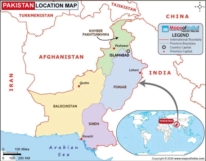
Pakistan is a country in South Asia, located at the crossroads of South Asia, Central Asia, and the Middle East. It occupies a strategic position in the northwestern part of the Indian subcontinent. Pakistan shares land borders with India to the east, Afghanistan to the west and northwest, Iran to the southwest, and China to the northeast. Its southern boundary extends along the Arabian Sea, giving the country access to important maritime routes.
Pakistan lies approximately between 23°35′ and 37°05′ north latitudes and 60°50′ and 77°50′ east longitudes. Its location places it between the mountainous regions of Central and South Asia and the Arabian Sea. The country covers an area of about 881,913 square kilometres, making it one of the larger countries in the region.
Pakistan and Its Neighbouring Countries
India shares Pakistan's longest international border, extending along its eastern side. The two countries are separated by the international boundary and the Line of Control in the Jammu and Kashmir region.
To the west and northwest, Pakistan borders Afghanistan. The rugged mountain terrain in this region forms part of the broader Hindu Kush and related mountain systems. Iran lies southwest of Pakistan, with the border passing through the dry and mountainous landscape of Balochistan.
China borders Pakistan in the north, across the high-altitude terrain of the Karakoram. The Khunjerab Pass is an important crossing between Pakistan and China and is also associated with the Karakoram Highway.
Physical Location of Pakistan
Pakistan has a diverse landscape because of its geographical location. The northern part of the country contains some of the world's highest mountain ranges, including the Karakoram, Himalayas, and Hindu Kush. K2, the second-highest mountain in the world, is located in Pakistan's Gilgit-Baltistan region.
The Indus River is the country's major river system and flows from the northern mountains through the plains before reaching the Arabian Sea. Much of eastern and central Pakistan consists of fertile plains associated with the Indus River system. In contrast, the western and southwestern areas include extensive dry and mountainous regions.
Pakistan's Major Geographical Regions
Pakistan's location is reflected in the country's varied geographical regions. The northern highlands contain rugged mountains, deep valleys, glaciers, and high-altitude plateaus. Moving southward, the landscape changes into the broad Indus Plain, which contains some of the country's most fertile agricultural areas.
The western part of Pakistan includes the dry and mountainous landscapes of Balochistan, while the southeastern region contains the Thar Desert, which extends across the border with India. Along the south, the Sindh coast meets the Arabian Sea, creating a transition between the country's inland plains and its coastal environment.
Pakistan's Location and Important Cities
Pakistan's geographical position is also reflected in the distribution of its major cities. Islamabad, the national capital, is located in the northern part of the country near the Margalla Hills. Lahore, one of Pakistan's major cultural and historical centres, lies in the northeast near the Indian border.
Karachi is situated on the southern coast along the Arabian Sea and serves as a major commercial and port city. Peshawar lies in northwestern Pakistan near the Afghanistan border, while Quetta is located in the mountainous Balochistan region near the country's border with Afghanistan.
On a map, Pakistan can therefore be identified in the northwestern part of the Indian subcontinent, with India on its eastern side, Afghanistan and Iran to the west, China to the north, and the Arabian Sea to the south.