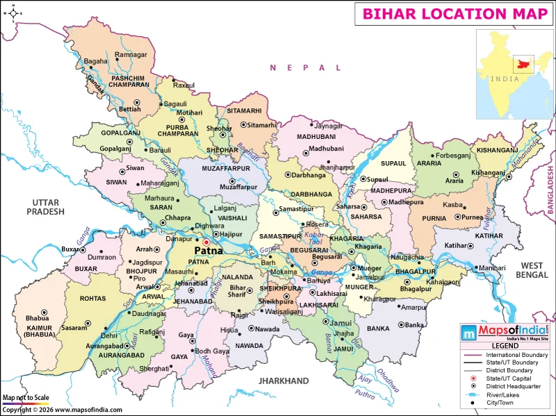
Bihar is a state located in eastern India, occupying a large part of the fertile Ganga Plain. It lies between the Himalayan region to the north and the plateau region of southern India. Bihar shares an international boundary with Nepal to the north, while Uttar Pradesh borders it to the west, Jharkhand to the south, and West Bengal to the east. Its geographical position places it at an important point between northern and eastern India, with the Ganga forming a major east-west geographical corridor across the state.
Bihar extends approximately between 24°20′N and 27°31′N latitudes and 83°19′E and 88°17′E longitudes. The state covers an area of about 94,163 square kilometres. Its location within the Ganga Plain gives it predominantly flat terrain and extensive fertile alluvial land.
Boundaries and Neighbouring Regions of Bihar
Bihar's geographical boundaries connect it with both India and the neighbouring country of Nepal. Nepal lies to the north, forming an international boundary along the northern edge of the state. Uttar Pradesh is situated to the west, Jharkhand to the south, and West Bengal to the east.
This position places Bihar between the Himalayan foothills and the plateau and plains of eastern and central India. Its location also provides a natural geographical connection between the northern plains and the eastern part of the Indian subcontinent.
Physical Geography of Bihar
The landscape of Bihar is dominated by flat alluvial plains formed by sediments deposited by the Ganga and its tributaries. The Ganga flows from west to east through the state and broadly divides Bihar into North Bihar and South Bihar.
North Bihar is characterized by extensive low-lying plains and numerous rivers flowing southward from the Himalayan region. South Bihar consists mainly of the southern Ganga Plain and gradually becomes more elevated toward the uplands adjoining Jharkhand. This difference in elevation and drainage creates distinct physical characteristics across the state.
Major Rivers
Bihar has an extensive river network that strongly influences its physical landscape. The Ganga is the principal river, while the Gandak, Kosi, Bagmati, Kamla, Mahananda, Son and Punpun are among the other major rivers.
Several rivers in northern Bihar originate in or pass through the Himalayan region and Nepal before entering the state. These rivers contribute to the deposition of fertile alluvial sediments but can also cause seasonal flooding, particularly during the southwest monsoon.
Climate and Natural Landscape
Bihar has a humid subtropical climate, characterized by hot summers, a southwest monsoon season and relatively cool winters. Most of the state's rainfall occurs between June and September.
The combination of flat terrain, fertile alluvial soils, river systems and seasonal rainfall has created favourable conditions for agriculture. Rice, wheat, maize, pulses and sugarcane are among the important crops cultivated in different parts of Bihar.
Administrative Location and Districts
Bihar is administratively divided into 38 districts and 9 administrative divisions. These districts extend across the northern and southern parts of the state and include areas influenced by different river systems and physical landscapes.
Patna, the state capital, is located on the southern bank of the Ganga and is one of the major urban centres of Bihar. Other important cities include Gaya, Bhagalpur, Muzaffarpur, Darbhanga, Purnia and Bihar Sharif.
Why Is Bihar's Location Important?
Bihar's geographical position between the Himalayan region and the eastern Ganga Plain has strongly influenced its physical and human geography. Its northern boundary with Nepal places it close to the Himalayan drainage system, while its southern boundary connects the plains with the plateau region of Jharkhand.
The Ganga and its tributaries have shaped the state's landforms, soils, agriculture and settlement patterns. At the same time, Bihar's position between Uttar Pradesh, Jharkhand, West Bengal and Nepal gives it an important geographical connection with neighbouring regions.
Overall, Bihar is defined geographically by its location in eastern India, position within the Ganga Plain, international boundary with Nepal, surrounding Indian states, extensive river network, fertile plains and monsoon climate. These features together give the state its distinctive physical and geographical character.


