Cyclone HudHud |
Cyclone Hudhud path and affected area map
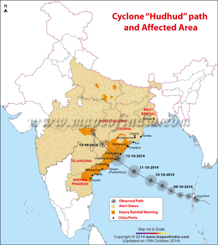
Map showing the Cyclone Hudhud Path
* Map Showing Cyclone Hudhud path, Alert States, Heavy Rainfall and Warning Area and affected area map
Why the cyclonic storm is called Hudhud?
The name for the storm HUDHUD is contributed by Oman. It is an Arabic word. It is Hoope Bird which is called Hudhud in Arabic.
A depression in the Andaman
On October 7, 2014, a low pressure area over Andaman Sea was upgraded to a depression by the India Meteorological Department (IMD). On October 8, when it made a landfall over an island in the Andaman, it was classified as a cyclonic storm.
The name Hudhud was given to the cyclone by Oman — in Arabic it refers to the Hoopoe bird. Why Oman? Because a procedure is followed while naming cyclones over this part of the Indian Ocean, and countries are allotted turns to name cyclones. Care is taken that no community’s sensitivities are hurt while giving names since cyclones are destructive. Accordingly, Oman named it Cyclone Hudhud.
Cyclone Hudhud upgraded to ‘very severe cyclonic storm’
On October 10, Cyclone Hudhud was upgraded to a “very severe cyclonic storm” in intensity, by the IMD. At 2.30 pm on October 10, it was centered near latitude 15.0º North and longitude 86.8º East, around 470 km east-southeast of the coastal city of Visakhapatnam. From there, the storm system was predicted to move in a direction west-northwestwards.
Preparing for the cyclone
The next day, on October 11, large-scale evacuation of people from the coastal areas of Odisha and Andhra Pradesh was underway. The two state governments planned to evacuate a total of 450,000 people. Four ships of the Indian Navy were on stand-by to aid in possible rescue missions. Around 25,000 people were moved from Visakhapatnam district and 46,000 from Srikakulam district in Andhra Pradesh. More than 140 emergency relief shelters had been opened in coastal Andhra. Nineteen teams of the National Disaster Response Force (NDRF) were deployed in the state. The army was on stand-by too.
Trains, flights cancelled; people braced themselves
The South Central Railway cancelled 28 express trains, and diverted 13; more than a dozen passenger trains were also cancelled. All flights to Visakhapatnam were cancelled.
Prime Minister Narendra Modi met senior officials to take stock of the preparedness for Cyclone Hudhud. It was decided that Union home minister Rajnath Singh would stay in constant touch with chief ministers of the affected states.
Ground zero
The next day, October 12, Cyclone Hudhud made landfall near Pudimadaka, some 50 km from Visakhapatnam in Andhra Pradesh at around 11.30 A.M.
Visakhapatnam was hit hard. The roof of the city’s airport was blown away; so were the communication services and power supplies. Approximately, 500,000 people had to be evacuated in Andhra Pradesh; 160,000 were evacuated in neighbouring Odisha. In Andhra Pradesh, the worst hit districts were Visakhapatnam, Srikakulam, East Godavari and Vizianagaram. In Odisha, Gajapati, Koraput, Malkangiri and Rayagada were among the worst affected. Overall, Andhra Pradesh faced the brunt of the storm.
Coping with the disaster
Till October 20, the death toll due to Cyclone Hudhud was reported to be 46. Of these, 29 deaths were reported from Visakhapatnam district alone, while 15 people died in Vizianagaram. The loss of food grain production was estimated to be around 2.2 million tonnes, according to government figures.
More than a week after the cyclone, 135,000 people were still in relief camps in Andhra Pradesh. More than 3,176 km of panchayat roads and 648 km of municipal roads were reported to be damaged.
Around 2.4 million customers in Visakhapatnam, Vizianagaram and Srikakulam districts were initially without power. Electricity supply was restored to 1.5 million consumers by October 20, according to government officials.
Most train services to the affected areas were restored by October 15. The bigger challenge was Vishakhapatnam airport. Navy and NDRF personnel helped AAI officials carry out restoration work of navigational tools and the runway. The prompt work showed results. On October 17, Air India resumed its flights from Vishakhapatnam airport.
In Odisha, according to initial estimates, crop loss has been pegged at Rs. 238 million. Cultivable area has been hit in the districts of Gajapati, Ganjam, Kandhamal, Kalahandi, Malkangiri, Koraput, Rayagada and Nabarangpur. Electricity supply to more than 770,000 consumers was affected in southern Odisha.
References: Media reports
Indian Meterological Department
WBSKA28102014
EBSSH
Cyclone HudHud: News and Updates
Cyclone Hudhud lashes Andhra Pradesh and Odisha
Cyclone Hudhud invaded the port city of Visakhapatnam (Andhra Pradesh) on Sunday, leaving in its wake widespread wreckage, fallen trees and damaged buildings. As per media reports, the cyclone, moving with deafening winds blowing at 190 kmph, has so far claimed five lives – while three persons were killed in Andhra Pradesh, two fatalities were reported from Odisha.
Several areas of the coastal Andhra Pradesh and Odisha are experiencing heavy rains since Saturday. In AP, cyclone has caused extensive damage due to torrential rains in three coastal districts – Visakhapatnam, Vijayanagaram and Srikakulam.
The authorities have closed the city airport and suspended train services in Visakhapatnam or Vizag, home to two million people and a major naval base. Most of the damage is seen in Visakhapatnam as winds are not too strong in Odisha, though heavy rainfall is expected in south Odisha. In Odisha, eight districts of Ganjam, Gajapati, Malkangiri, Koraput, Rayagada, Nabarangpur, Kandhamal and Kalahandi are expected to bear the brunt of the cyclone.
As per the India Meteorological Department (IMD) forecast, the cyclone may result in the flooding of low-lying coastal areas in AP. At Vizag port, the ships which had been in the harbour were moved offshore to escape the wrath of the high seas. As part of rescue operation, around 150,000 people were evacuated from several districts of Andhra Pradesh to high-rise buildings, shelters and relief centres.
The IMD has forecast that Hudhud’s peak wind speeds will drop to 60 kmph by Monday afternoon, but heavy rainfall will continue till 15 October 2014. As the cyclone progresses, it will cause heavy rainfall in Chhattisgarh, Bihar, East Madhya Pradesh and East UP and Gangetic belt of West Bengal.
Home Minister Rajnath Singh spoke at length with Andhra Pradesh and Odisha Chief Ministers N Chandrababu Naidu and Naveen Patnaik to assess the situation arising out of Hudhud’s menacing advance.
Meanwhile, the Global Disaster Alert and Coordination System (GDACS), managed by the United Nations and the European Commission, has forecast that Hudhud may gain even higher peak wind speeds of 212 kmph.
Incessant rains caused by Cyclone Hudhud kill 18 in Uttar Pradesh
11:20 AM, 15 October 2014
Incessant rainfall caused by the Cyclone Hudhud has caused massive destruction, death and anguish in several parts of Uttar Pradesh. A government official on Wednesday, October 15, has confirmed to media the loss of 18 lives with the ruination of standing crops and adding that many houses collapsed in eastern part of the state.
Though the heavy rainfall since Tuesday stopped on Wednesday, several regions in the state capital, including Charbagh railway station, Indiranagar, Sitapur Road, Gomtinagar and Thakurganj remained waterlogged and submerged.
It is reported that the heavy rains this time has broken previous records and Tuesday experienced the maximum rainfall of 61.1 mm in a single day in October ever.
WBASH151014
Hudhud cyclone: Death toll rises to 24; AP, Odisha seeks relief
12:45 PM, 14 October 2014
The death toll rose to 24 in Odisha and Andhra Pradesh as a result of the devastation caused by Cyclone Hudhud. As per media reports, in Andhra Pradesh 15 people have died in Visakhapatnam, one in Srikakulam and five in Vizianagaram. According to media reports, Prime Minister Narendra Modi is expected to visit Visakhapatnam today. It is also reported that N. Chandrababu Naidu, Andhra Pradesh Chief Minister is seeking financial assistance and relief from the Prime Minister and to declare the cyclone as
a national disaster.
WBST141014
Post landfall outlook as per IMD
1.30 PM, 12 October 2014
Even after landfall the system would maintain the intensity of very severe cyclonic storm for 6 hours and gradually weaken into a cyclonic storm in subsequent 6 hours while moving northwestwards across south interior Odisha and Chattisgarh. Under its influence rainfall at most places with heavy falls at a few places would occur over south Chattisgarh, adjoining Telangana and south Odisha
and isolated heavy to very heavy falls over north Chattisgarh,east Madhya Pradesh and north Odisha.Gale wind speed reaching 100-120 kmph gusting to 130 kmphwould also prevail for 6 hours
after landfall and 80-90 kmph gusting to 100 kmph for subsequent 6 hours over East Godavari, Visakhapatnam,Vizianagaram and Srikakulam districts of north Andhra Pradesh and Ganjam, Gajapati, Koraput and Malkangiri districts of Odisha during the same period. Squally winds speed reaching 55 – 65 kmph gusting to 75 kmph would also prevail for next 12 hours after landfall over south Cattisgarh and adjoining districts of north Telangana and south Odisha.
Latest Update
Next 6 to 12 hours very critical. Northern coastal districts of Andhra Pradesh will see heavy rain and high speed winds, says L.S. Rathore, DG, IMD. Eastern Uttar Pradesh, Madhya Pradesh and Chhattisgarh will also see rainfall. Cycone Hudhud is just crossing Vizag at speed of 170-180kmph gusting up to 190kmph.
Helpline number Cyclone Hudhud: Andhra Pradesh – 9849904019, 0853 – 2234870,2234301; Sambalpur – 0663-2533037, 8455886999; Visakhapatnam – 0891-2842415
5 diving teams dispatched to Srikakulam, 10 teams to low-lying areas in and around Vizag for rescue and relief operations: Navy.
11.45 AM, 12 October 2014
Hudhud makes landfall. 2 people killed,Wind speed at the coast is more than 170 km/hour.
———–
11.40 AM, 12 October 2014
Cyclone Hudhud Update : Cyclone Hudhud makes landfall at Kailashgiri in Visakhapatnam
————–
The landfall of Hudhud is taking place. TheEye of the cyclone Hudhud will pass through Kalinga, Bheemunipatnam. Diameter of eye is 50km wide, will be a lull in storm between 11AM-12:30PM according to latest reports.
HudHud Latest Update
11.10 AM, 12 October 2014
According to News sources, 5 diving teams are dispatched to Srikakulam, 10 teams to low lying areas in and around Vizag for rescue and relief operations. Two killed in rain-related incidents in Visakhapatnam and Srikakulam districts under the influence of severe cyclonic storm Hudhud.Current status of Cyclone Hudhud, wind speed more than 200 kmph
———————
The Current windspeed of HUDHUD is more than 190 km per hour.
Vizag port, airport operations suspended as Cyclone Hudhud closes in
Power outage in most parts of Visakhapatnam due to cyclonic impact.
Cyclone Hudhud helplines: Ministry of home affairs, Delhi: 011-23093563, 23093566; Odisha: 1948, Andhra Pradesh: 1949
———————–
Cyclone HUDHUD going to make its landfall in few minutes
10.30 AM, 12 October 2014
According to the latest information the cyclone is just 20 Km away from Vizakhapatnam coast. It is going to make its land fall in few minutes. It is a category 4 cyclone which is equate to Phailin at the time of landfall. Wind speed is expected to be 170-180 kph.
CYCLONE WARNING FOR SRIKAKULAM, VIZIANAGARAM, VISAKHAPATNAM, EAST GODAVARI AND WEST GODAVARI DISTRICTS
7.00 AM, 12 October 2014
According to the the latest Warning issued by Cyclone warning centre, visakhapatnam, the Very Severe Cyclonic Storm ‘HUDHUD’ over west central Bay of Bengal moved slightly North Northwestwards during with a speed of about 06kmph during last 06 hours and lay centered at 2330 hrs IST of 11th October 2014 about 210 km Southeast of Visakhapatnam. The system would move Northwest wards and cross north Andhra Pradesh coast close to Visakhapatnam around noon of today the 12th October 2014.
Under the influence of the system
(i) Heavy rainfall warning: Rainfall would occur at most places with heavy to very heavy rainfall at a few places and isolated extremely heavy falls would occur over Srikakulam, Vizianagaram, Visakhapatnam, East and West Godavari districts of North Coastal Andhra Pradesh during next 48 hours. Rainfall would occur at most places with heavy to very heavy rainfall at isolated places over Krishna, Guntur and Prakasam districts of Andhra Pradesh.
(ii) Wind warning: Gale winds speed reaching 90 to 100 kmph gusting to 110 kmph would prevail along and off North Coastal Andhrapradesh during next 06 hours. The wind speed would gradually increase to 170-180 kmph gusting to 195 kmph around the time of land fall along and off North Andhra Pradesh(Srikakulam, Vizianagaram, Visakhapatnam, East Godavari districts) and 80 to 90 kmph along and off adjoining districts West Godavari and Krishna.
(iii) Sea condition: Sea condition would be very high during next 06 hrs. It would gradually become phenomenal from today the 12th morning onwards along and off north coastal Andhrapradesh and very rough to high along and off south coastal Andhrapradesh.
(iv) Storm surge warning: Storm surge about 1 to 2 meters above astronomical tide would inundate low lying areas of Visakhapatnam, Vizianagaram and Srikakulam districts of north coastal Andhrapradesh at the time of landfall.
(v) Port warning: Great Danger Signal number TEN kept hoisted at Kalingapatnam, Bheemunipatnam, Visakhapatnam, Gangavaram ports. Great Danger signal number EIGHT kept hoisted at Kakinada and Machilipatnam ports.
Local Cautionary signal number THREE kept hoisted at Krishnapatnam, Nizampatnam and Vadarevu ports.
(vi) Damage expected to North Coastal Andhra Pradesh (Srikakulam, Vizianagaram, Visakhapatnam, East Godavari): Extensive damage to kutcha houses, uprooting of big trees and partial disruption of power and communication lines, Minor disruption of rail and road traffic. Potential threat from flying debris, Flooding of escape routes, damage to agriculture crops over Srikakulam, Vizianagaram, Visakhapatnam and East Godavari districts.
(vii) Damage expected to West Godavari and Krishna districts: Damage to thatched huts, breaking of tree branches causing minor damage to power and communications lines. Uprooting of small trees. Damage to agriculture crops.
(viii) Action suggested to Srikakulam, Vizianagaram, Visakhapatnam and East Godavari Districts: Total suspension of fishing operations in the area of influence of cyclone. Mobilise extensive evacuation from coastal areas. Diversion or suspension of aviation, navigation, rail and road traffic. People in affected areas to remain at safe places around landfall period.
(ix) Action suggested to west Godavari and Krishna Districts: Total suspension of fishing operations. People in affected areas to remain at safe places.
More than 150,000 evacuated in Andhra Pradesh
6.00 AM, 12 October 2014
Ahead of Cyclone Hudhud, classified as very severe, more than 1.5 lakh people have been evacuated to 370 relief camps and shelters from four frontline districts of Visakhapatnam, Srikakulam, Vizianagaram and East Godavari of Andhra Pradesh on Saturday. With expected rainfall of up to 45 cm and wind speeds of 180 kmph, Hudhud is due to make landfall between Visakhapatnam and Kalingapatnam in Srikakulam district on Sunday morning.
HUDHUD Preparedness at state levels
11:25 PM, 11 October 2014
Andhra Pradesh
The State Government has put five districts of Srikakulam, Visakhapatnam, Vizianagaram and East and West Godavari on high alert as the very severe Cyclonic Storm Hud Hud is likely to landfall in Visakhapatnam District. The state government has set up 370 relief camps and evacuating people from 396 villages from theses districts.Thirty teams from Eastern Naval Command and one column of Army have been kept on standby at Visakhapatnam while 13 NDRF teams are in place to undertake relief and rescue operations.
Odisha
The Odisha government has started evacuating people from vulnerable areas in southern parts of the state to safer places and multi-purpose cyclone centres as part of its efforts to ensure ‘zero casualty’ in the very severe cyclone HUDHUD heading towards the eastern coast.
The local administration, National Disaster Response Force and Odisha Disaster Rapid Action Force. fire brigade personnel have been pressed into service to evacuate people in eight southern districts of Odisha.
Special Relief Commissioner of Odisha, PK Mohapatra, has said about 3.5 lakh people including tribal people from the inaccessible Bonda hills in Malkangiri would be evacuated. Many parts of Odisha have already started receiving rainfall.
West Bengal
The state expects heavy to very heavy rainfall with wind speeed of about 100 km per hour along and off Odisha coast from today night under the impact of cyclonic storm HUDHUD.
West Bengal Government has issued alert warning in four Coastal Districts of the state in view of cyclonic storm Hudhud.Chief Minister Miss. Mamata Banerjee on Saturday reviewed the preparedness of the coastal districts to deal with the situation.A 24 our control room has been opened at the state secretariat to monitor the situation in the coastal areas. The State Disaster Management Minister Javed Khan said that North and South 24 Parganas, East Midnapore and Howrah District administrations have been put on high alert. Leave of Government employs in the coastal districts have been cancelled.
——————–
A girl drowned and a 11-year-old boy missing after a boat engaged in evacuation capsized
09:35 PM, 11 October 2014
A mechanized boat of the Forest department, carrying mostly pregnant women and children, capsized in a crocodile-infested creek in Kendrapara district. A girl is downed and 11 year old boy was missing after a boat engaged in evacuation of people in view of the advancing ‘HudHud’ cyclone capsized in a crocodile-infested creek in Odisha’s Kendrapara district on Saturday.
In wake of the very severe cyclone storm over Bay of Bengal moving towards the coast, the Kendrapara district administration started evacuating vulnerable sections of the population from Satabhaya, situated on the edge of the sea. The boat was carrying mostly pregnant women and children from Satabhaya gram panchayat. The mechanised boat of the Forest department, was carrying about 25 people from Baunsagadi. In the middle of the creek, the boat overturned. Women and children fell inside the creek. They saved their lives by swimming up to the coast. Fortunately, none of them was attacked by crocodiles. None of the villagers had worn life jacket.
———————-
09:15 PM, 11 October 2014
India Meteorological Department has upgraded the HUDHUD to Red Message. According to the latest release from IMD, The very severe cyclonic storm HUDHUD lay centered around 250 Km south east of Visakhapatnam and 340 Km south southeast of Gopalpur.
Storm surge of 1 to 2 meters has also been provided to low lying areas of Visakhapatnam, Vijayanagaram and Srikakulam districts of North coastal Andhra Pradesh.
According to the latest report from IMD even after the landfall of HUDHUD, the intensity of the very severe cylonic storm will be maintained for 6 hours and gradually weaken into a cyclonic storm in the next 6 hours as it moves to south interior Odisha and Chattisgarh.
Wind speed will be 100 to 120 kmph which will prevail for 6 hours after landfall.
——————–
3:30 PM, 11 October 2014
Rains have started in most of the places in coastal and south Odisha and coastal Andhra Pradesh. Heavy to very heavy rainfall at a few places over districts of Malkangiri, Koraput, Rayagada, Nawarangpur, Ganjam, Gajpati, Kalahandi and Phulbani of south Odisha is expected since this evening. Heavy to very heavy rainfall will also occur at one or two places in districts of Khurdha, Puri, Jagatsinghpur, Nayagarh, Boudh, Nawapara, Sonepur and Bolangir.
The Indian Meterological Department has warned wind speed from 80-90 kmph along and off Odisha coast from today evening. HUDHUD is likely to make heavy damage to thatched huts, power and communication lines, agricultural crops and uproot a large number of trees. People in the likely-affected districts have been advised to shift to safer places. Fishing operations have been totally suspended along and off Odisha coast and fishermen have been advised not to venture into sea.
The East Coast Railway has cancelled 35 south-bound trains and diverted and short-terminated several other trains in the southern zone as a precautionary measure in view of HUDHUD.
Andhra Pradesh Government has put five districts on high alert. Srikakulam, Visakhapatnam , Vizianagaram and east Godavari have been put on high alert and the district administration have been asked to take all steps to prevent losses. The state government has set up 370 relief camps and identified 3 lakh 92 thousand people in 396 villages for evacuation.
Eastern naval command has kept 30 naval teams, one column of Army have been kept standby at Visakhaopatnam. 13 NDRF teams have been deployed and 3 teams have been kept on stand by.
Prime Minister Narendra Modi will chair a high level meeting this evening to review the preparedness for the fast approaching cyclone Hudhud which is likely to hit Odisha and Andhra Pradesh tomorrow.
————————–
East Coast Railway cancels 35 trains, over 30 routes affected
12:15 PM, 11 October 2014
Railways has cancelled certain trains and diverted the route of several others. Cyclone Hudhud is expected to make landfall on the coasts of Odisha and Bhubaneshwar in the fornoon of October 12
The East Coast Railway (ECoR) has cancelled as many as 35 trains running between Bhubaneswar and Visakhapatnam route from the morning of October 12. The cancelled trains include 18463-Prasanti Express, 18411-Bhubaneswar-Vishakhpatna Inter City, 12845-Bhubaneswar-Yashwantpur Express, 17015-Bhubaneswar-Secunderabad Vishakha Express, 18401-Puri-Okha Express, 22871-Bhubaneswar-Tirupati Express, 17479-Puri-Tirupati Express, 11020-Bhubaneswar-Mumbai Konark Express, 22859-Puri-Chennai Express. Few trains like Tirupati-Puri Express, Vishakha Express, Prasanti Express, Vishkhapatanam Express also stand cancelled from Vishakhpatanam.
——————-
HUDHUD Preparedness
7.40 am, 11 October 2014
Cyclone Hudhud is fast approaching the Odisha and North Andhra Pradesh coast. It is likely to make landfall at Visakhapatnam on Sunday afternoon.
Odisha government has asked the Center to send satellite phones for rescue and relief work. Home Minister Rajnath Singh has also spoken to the chief ministers of Andhra Pradesh, Telangana and Odisha, and discussed the plan to combat cyclone Hudhud.
Home Minister Rajnath Singh said that the NDRF has set up a control room at Delhi whose number is 011-26107953. People can also call on Mobile number 09711077372 and email [email protected] for any assistance.
According to sources HUDHUD if compared to Cyclone Phailin, the wind speed is much lower. Cyclone Phailin had speeds going up to 200kph, but the category of both the systems are same.
According to the National Disaster Response Force (NDRF) its preparations are on war-footing to deal with any emergency. According to sources NDRF has deployed battalions in Odisha and Andhra Pradesh. NDRF has also kept their forces in West Bengal on alert. The official said that the priority was to set up communications, which is often the first casualty of any natural disaster.
Odisha Chief Minister Naveen Patnaik has requested Defence Minister Arun Jaitley to ask the Air Force to be ready to help with rescue and relief operations, if needed.
——————————
HUDHUD update
6.30 am, 11 October 2014
The very severe cyclonic storm HUDHUD is located over the west central Bay of Bengal has moved north-west wards during the past 6 hours and is located at about 420 km south east of Visakhapatnam and 450 Km south South of Gopalpur. The cyclone is expected to move West North west ward and cross north Andhra Pradesh coast around Visakhapatnam by forenoon of 12th October 2014.
Wind speed is expected to increase to 80 -90 km ph along and off the coast of Odisha and Andhra pradesh from 11th Evening. Fishermen are advised not to venture into the sea. Signal Number III is hoisted in all the ports in the affected region.
—————————
11.30 pm, 10 October 2014
Very Severe Cyclonic Storm HUDHUD is located at West Central Bay of Bengal has moved north West during the last 6 hours and is located 460 km east -south east of Visakhapatnam and 490 Km south-south east of Gopalpur.
According to the latest information bulletin by Meteorological centre Bhubaneswar, heavy to very heavy rainfall may occur at one or two places over south Odisha during next 24 hours and heavy to very heavy rainfall at a few places over districts of Malkangiri, Koraput, Rayagada, Nawarangpur, Ganjam, Gajpati, Kalahandi and Phulbani of south Odisha in subsequent 48 hours. Heavy to very heavy rainfall at one or two places in districts of Khurda,Puri, Jagatsinghpur, Nayagarh, Nawapara, Boudh, Sonepur and Bolangir during the same period.
——————
Latest Update from Indian Meteorological Department
8.15 pm, 10 October 2014
The cyclonic storm HUDHUD is moved northwestward and has intensified into a very severe cyclonic storm. It is located 470 km east-southeast of Visakhapatnam and 520 km south southeast of Gopalpur.
Suspension of fishing operation has been suggested in districts of North Andhra Pradesh including East Godavari, Visakhapatnam, Vizianagaram and Srikakulam. Regulation of road, rail air transport is also suggested. Total suspension of Fishing is suggested for South Andhra Pradesh and South Odisha.
—————-
Andhra Pradesh makes evacuation arrangements
6.00 pm, 10 October 2014
The Andhra Pradesh government is taking steps to minimize damages due to the cyclonic storm Hudhud. The state has made all arrangements to evacuate people in low lying areas of coastal districts to safer places. Cyclone Hudhud is expected to cross north Andhra Pradesh coast on Oct 12 and is expected to make landfall close to Visakhapatnam, according to Cyclone Warning Centre at Visakhapatnam
————–
5.00 P.M, 10 October 2014
Tropical Cyclone Hudhud, is strengthening as it churns over the Bay of Bengal.
As of 3 p.m, India time Friday, Hudhud exhibited maximum sustained winds of 75 mph, making it the equivalent of a Category 1 hurricane. Hudhud is now moving northwest and strengthening. According to U.S. military’s Joint Typhoon Warning Center Hudhud will become a Category 3 hurricane when the landfall takes place in the east-central coast of India in eastern Andhra Pradesh or Odisha on Sunday morning.
————————-
IMD warns about severity of HudHud cyclone; Centre offers help
12.30 P.M, 10 October 2014
India Meteorological Department (IMD) has warned that the cyclone HuhHud will take a severe turn soon and will bring gusting winds of about 100-110 km/hour along with the heavy rains to Andhra Pradesh and Odisha coasts. According to media reports, Home Minister Rajnath Singh has discussed about the preparations with the Chief Ministers of both the states, to face the cyclone and has offered help from the Centre. According to media reports, before the landfall, the cyclone is expected to move from Category 1 cyclonic storm to Category 4 cyclonic storm.
———————–
The Andhra Pradesh Signal number 2 has been hoisted at major ports in the state. The government has alerted all the coastal district administrations for bracing its first cyclonic storm over the Bay of Bengal this year. Control rooms are being opened in district collectorates and mandal offices. Coastal Andhra Pradesh is likely to experience gale and rains beginning 11th morning. Distant cautionary signal number 2 kept hoisted in all major ports in the State.
The phone numbers are 1800-425-6625, 0894-2225361 and 9652838191.
HUDHUD cyclone is expected to cross North Andhra Pradesh and South Odisha coast between Visakhapatnam and Gopalpur around 12th October Noon. Distant Warning Signal Number- 2 has been kept hoisted at Paradip and Gopalpur ports in Odisha. Fishermen in deep sea have been advised to return to coast immediately.
Steps taken by Odisha Government
– The leaves of all employees are cancelled
– Round the clock control room set up in district offices
– Odisha Disaster Rapid Action Force, NDRF, Fire services deployed in areas expected to be hit by HUDHUD
– State government in Full Alert to deal with any emergency
12.40 P.M., 08 October 2014
According to India Meteorological Department (IMD), the cyclonic storm which is brewing in the Bay of Bengal is likely to hit the coast of Odisha and north of Andhra Pradesh by 12 October. As per media reports, the effect of the cyclone will be seen in the form of heavy rains and strong winds in the Andaman and Nicobar Islands. It is reported that the cyclone which is likely to be called Hud Hud will hit south Odisha coast and north coastal Andhra Pradesh soon and during the landfall period the regions like Vizinagaram, Srikakulam and Vishakhapatnam will receive heavy rainfall.
WBST081014
WBST101014
Ref: Media Reports
View All Hurricanes and Tropical Cyclones:
Cyclone Kyant
Cyclone Roanu
Cyclone Komen
Cyclone Ashobaa
Cyclone Nilofar
Cyclone Phailin
Cyclone Prone Areas in India
SMS-Based Cyclone Warning System Launched in India