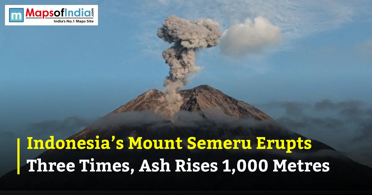
Indonesia’s Mount Semeru, one of the country’s most active volcanoes, erupted three times on September 14, 2026, sending volcanic ash up to 1,000 metres above its summit. The repeated eruptions highlight the continuing activity of the East Java volcanoes and warn of the need to monitor one of the most prominent volcanoes in Indonesia.
Mount Semeru is notorious for its many eruptions and high plumes of ash. After this latest event, its activity has again been a talking point for Indonesia's location on the Pacific Ring of Fire, an area known for its seismicity and many active volcanoes.
Three Eruptions Recorded in the Morning
The three eruptions took place in a short time on Monday morning, 14 September 2026. The ash column from each eruption was at a different height, with the highest from the third eruption.
The reported eruption sequence was:
- 4:20 a.m.: The first eruption produced an ash column approximately 500 metres above the summit, reaching around 4,176 metres above sea level.
- 5:53 a.m.: The second eruption sent ash approximately 800 metres above the summit, reaching around 4,476 metres above sea level.
- 6:28 a.m.: The third eruption produced the highest ash column, reaching approximately 1,000 metres above the summit, or around 4,676 metres above sea level.
The third eruption was approximately 140 seconds in duration and was recorded by a seismograph. The ash column was dark grey and was observed to rise to the east. Ash from earlier eruptions was directed to the northwest and to the northwestern direction.
The continuous activity showed that the activity of Mount Semeru is still eruptive and needs close observation of conditions around the volcano.
Where Is Mount Semeru Located?
Mount Semeru is situated on the border of Lumajang and Malang regencies in East Java, Indonesia. It is Java's highest mountain with a height of about 3676 metres above sea level.
The volcano is located in Indonesia's volcanic mountain system, surrounded by forests, valleys and settlements. Its impressive height makes it a prominent landmark of Java.
Mount Semeru is also called Mahameru, which translates to “Great Mountain.” The volcano is a natural landmark, but its frequent eruptions make the surrounding region vulnerable to volcanic hazards.
Why Is Mount Semeru an Active Volcano?
Indonesia is situated in a region of the Earth where the activity of several tectonic plates takes place, commonly known as the Pacific Ring of Fire. These geologic occurrences help to make earthquakes and volcanoes common in the country.
Mount Semeru is located in the Sunda volcanic arc that formed as a result of plate movements in the area. Geological processes can create magma due to one tectonic plate sliding under another. When magma rises towards the surface, it can lead to volcanic eruptions.
Semeru is an eruptive volcano with a long history. Its eruptions may release volcanic ash, gases, lava, and other materials. Some eruptions are relatively small, while others can produce larger ash columns and more dangerous volcanic flows.
The height of an ash column depends on several factors, including the strength of the eruption, the amount of material released, and atmospheric conditions.
Mount Semeru’s Alert Level and Safety Measures
At the time of the reported eruptions, Mount Semeru was in stage III Siaga under the four-level volcanic alert system implemented in Indonesia. This is the second-highest alert level, meaning that there is a high level of volcanic activity, and strict safety precautions should be taken.
The authorities have urged residents against entering areas around the volcano that have been declared as danger zones. Restrictions are especially critical near the summit and places that are exposed to volcanic flows.
Also, there have been warnings made about the dangers in the Besuk Kobokan River and associated waterways. These can occur in areas as a result of hot volcanic clouds, falling volcanic material or lahars.
The public is warned to adhere to instructions provided by the Officials and not to enter restricted areas. Conditions on a volcano can shift rapidly, so it is important that people are kept up to date with notices from monitoring authorities.
What Are the Dangers of a Mount Semeru Eruption?
Several hazards can be created during the eruption of Mount Semeru for the community and visitors around this volcano. These can include volcanic ash, pyroclastic flows, lava, falling rocks and lahars.
Volcanic ash is composed of small pieces of rock and volcanic material thrown up in an eruption. Ash can be carried in the air and can spread around. Ashfall can cause decreased visibility, impact air quality, and fall on roads, buildings, farmland, and other surfaces.
Pyroclastic flows are the rapidly flowing combination of hot gases, ash, and volcanic fragments. May run down very quickly the sides of a volcano and may be very dangerous to persons in their path.
Mudflows containing water, volcanic ash, rocks and other materials are called lahars. These can occur due to heavy rain and volcanic loose material on the mountain. These flows may be transported by rivers and valleys to locations further downstream of the summit of Semeru.
At times when volcanoes are active, it is important that residents understand what to do if they are evacuated, and that visitors adhere to regulations that are in place.
How Is Mount Semeru Monitored?
The activity of Mount Semeru is monitored by Indonesia's Volcanology and Geological Hazard Mitigation Centre (PVMBG). The agency keeps track of volcanic activity and shares information that is used to determine what hazards exist and to set up safety measures.
Monitoring includes the study of volcanic earthquakes, ash emissions and the frequency and intensity of eruptions. Seismographs are used to record seismic vibrations related to the activity of the volcano, and visual observation is used to determine the characteristics of the ash column and its behaviour.
The three eruptions of September 14 were observed at various times, with the last eruption with the highest ash column. These observations can be used to evaluate the activity of the volcano and to warn the public about volcanic dangers.
Mount Semeru and Indonesia’s Volcanic Landscape
Mount Semeru is a natural landscape and geological heritage of important value in Indonesia. It is the highest mountain in Java and one of the most active volcanoes in the country, symbolizing the beauty and danger of volcanic environments.
Indonesia is located in the Pacific Ring of Fire, and it has shaped Indonesia's geology. Such geologic features can attract tourists and offer ecosystems found nowhere else, but they must also be closely monitored and be “disaster-ready.”
The eruptions of Mt. Semeru this time are a reminder that volcanic eruptions can happen over and over, sometimes in a short time. It is still essential for people living in the area and for those intending to visit the area to continue to monitor, publicize and follow safety guidelines.
FAQs
1. How many times did Mount Semeru erupt on September 14, 2026?
Indonesia’s Mount Semeru reportedly erupted three times on September 14, 2026. The eruptions occurred during the morning and produced ash columns of varying heights, with the highest reaching approximately 1,000 metres above the summit.
2. How high did the ash from Mount Semeru rise?
The highest ash column from Mount Semeru rose approximately 1,000 metres above the summit during the reported September 14, 2026, eruption.
3. Where is Mount Semeru located?
Mount Semeru is located in East Java, Indonesia, along the border of Lumajang and Malang regencies. It is the highest mountain on Java Island, standing at approximately 3,676 metres above sea level.
4. Is Mount Semeru an active volcano?
Yes, Mount Semeru is one of Indonesia’s most active volcanoes. It has a history of frequent eruptions, including ash emissions, explosive activity, and volcanic material released from its crater.
5. Why does Mount Semeru erupt frequently?
Mount Semeru is located in Indonesia’s volcanic belt, where tectonic plate movements contribute to magma formation and volcanic activity. Rising magma and pressure beneath the volcano can lead to repeated eruptions.
6. What is the alert level of Mount Semeru?
Mount Semeru was reported to be under Level III, or Siaga (Alert), in Indonesia’s four-level volcanic warning system during the reported eruptions. This level indicates significant volcanic activity and the need for safety precautions.
7. What are the dangers of a Mount Semeru eruption?
A Mount Semeru eruption can produce volcanic ash, pyroclastic flows, lava, falling rocks, and lahars. These hazards may affect nearby communities, roads, rivers, and visitors in areas surrounding the volcano.
8. Why is Indonesia prone to volcanic eruptions?
Indonesia lies along the Pacific Ring of Fire, where several tectonic plates interact. This geological setting contributes to the country’s frequent earthquakes and volcanic eruptions, making it one of the world’s most volcanically active regions.