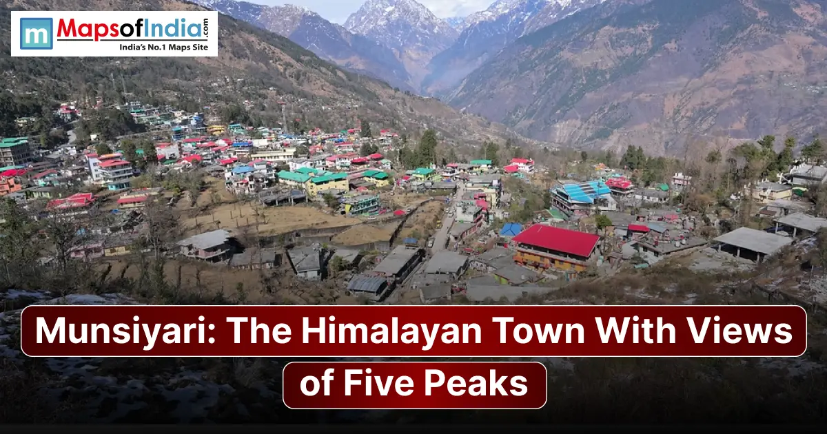
Munsiyari is a town in Uttarakhand’s Pithoragarh district, located in the Johar Valley at roughly 2,135 metres above sea level. It is best known for its views of the five Panchachuli peaks and as a base for trekking, including routes toward Milam, Ralam, and Namik glaciers.
Where Is Munsiyari?
Munsiyari lies in the Kumaon Himalayas of Pithoragarh district, Uttarakhand, along the Gori Ganga River and near the Indo-Tibetan border. The current Pithoragarh district website lists its altitude as 2,135 metres. The road distance from Delhi is 552 km, while Kathgodam is about 275–300 km away.
| Quick Fact | Details |
| Location | Pithoragarh district, Uttarakhand |
| Altitude | 2,135 m |
| Delhi distance | About 552 km by road |
| Nearest railhead | Kathgodam, about 275–300 km |
| Nearest airport | Naini Saini Airport, Pithoragarh; about 94 km |
| Best season | April–June and September–November |
The district administration currently lists Naini Saini Airport as 94 km away and Kathgodam at about 300 km.
The Five Peaks You Can See From Munsiyari
The five Panchachuli peaks are Panchachuli I, II, III, IV, and V, forming the snow-covered skyline associated with Munsiyari and the surrounding eastern Kumaon Himalayas. Government records list their elevations as follows.
Panchachuli Peaks (I–V) — Name each with elevation
| Peak | Elevation |
| Panchachuli I | 6,355 m |
| Panchachuli II | 6,904 m |
| Panchachuli III | 6,312 m |
| Panchachuli IV | 6,334 m |
| Panchachuli V | 6,437 m |
Panchachuli II is the highest of the five, rising to 6,904 metres. The group is one of the defining mountain views associated with Munsiyari.
Best Time to Visit Munsiyari
Season-by-season breakdown
Spring and summer generally offer conditions for sightseeing and trekking, while autumn is valued for crisp mountain views. Monsoon can bring rain and landslides, whereas winter brings cold conditions and snowfall.
| Month | Weather | Recommended For |
| April–June | Pleasant, clearer skies | Trekking, sightseeing, peak views |
| July–August | Heavy rain | Green landscapes; travel disruptions possible |
| September–October | Clear and cool | Trekking, photography |
| November–March | Cold, possible snow | Snow experiences and winter scenery |
For travellers, April–June and September–November provide practical windows for exploring Munsiyari, although conditions can vary each year.
How to Reach Munsiyari
By Air
Naini Saini Airport at Pithoragarh is listed by the district administration as 94 km from Munsiyari. Flight availability should be checked before planning around it. Pantnagar is another airport option. Requires a much longer road journey.
By Train
Kathgodam is the railhead used for reaching Munsiyari, roughly 275–300 km away. From Kathgodam, travellers continue by road toward Munsiyari.
By Road (from Delhi, Kathgodam, Almora)
Munsiyari is reached by road. The journey from Delhi is 552 km, while the route from Kathgodam is approximately 275 km. Almora is 200 km away by road. Buses and taxis connect Munsiyari with Uttarakhand towns.
Top Places to Visit in Munsiyari
Khaliya Top
Khaliya Top is one of the area's known trekking destinations. The trail provides Himalayan views, including Panchachuli and other high peaks. Uttarakhand Tourism identifies Khaliya Top as a trekking and skiing location near Munsiyari.
Birthi Falls
Birthi Falls is a waterfall attraction near Munsiyari. The Uttarakhand tourism master plan specifically identifies the Birthi Falls route as a tourism development area.
Nanda Devi Temple
The Nanda Devi Temple is a religious and scenic attraction. Incredible India notes that the temple can be reached by a walk/trek from Munsiyari and that the nearby hilltop provides wide Himalayan views.
Tribal Heritage Museum
The local museum presents aspects of the culture, history, traditions, and lifestyle of the area's communities, providing context beyond Munsiyari's mountain scenery.
Milam Glacier Trek
Munsiyari serves as a base for the Milam Glacier trek. The route follows the Gori Ganga valley through settlements including Lilam and Milam before reaching the glacier.
Things to Do in Munsiyari
Trekking routes
Routes include Khaliya Top and longer trails toward Milam, Ralam, and Namik glaciers. Uttarakhand Tourism specifically lists the Munsiyari–Martoli–Milam–Ralam routes among the region's trekking trails.
Village walks & local culture.
Walking through villages offers opportunities to experience traditional Kumaoni and Shauka cultural influences, including traditional houses, local crafts, and mountain lifestyles. Munsiyari historically served as a centre of the Johar Valley and Tibet trade routes.
Photography spots for peak views
Mornings and evenings can provide striking views of the Panchachuli massif. Khaliya Top and Nanda Devi hilltop are viewpoints for Himalayan photography.
Where to Stay in Munsiyari
Budget / Mid-range / Homestays
Accommodation includes hotels, guesthouses and homestays, with government-supported tourism accommodation also available in the wider area. Homestays can be particularly useful for travellers in experiencing local culture.
Travel Tips for Munsiyari
Munsiyari's elevation means nights can be cold outside winter. Weather and road conditions can change quickly during monsoon and winter. For treks toward border areas and Inner Johar Valley destinations, check permit requirements with local authorities before travelling. Carry layers, sturdy footwear, rain protection, medicines you normally need, and offline navigation because connectivity can be inconsistent in remote areas.
Conclusion
Munsiyari combines scenery, Panchachuli peak views, trekking routes, and local culture in one of Uttarakhand's less-commercialised mountain destinations. From Khaliya Top and Birthi Falls to the Milam Glacier route, it offers options for both short sightseeing trips and longer Himalayan adventures.
FAQs
1. What is Munsiyari famous for?
Munsiyari is famous for its views of the five Panchachuli peaks, Himalayan landscapes, and trekking routes. It is also a base for exploring the Milam, Ralam, and Namik glaciers and the wider Johar Valley. Its location in Pithoragarh district makes it an important gateway to Uttarakhand's high mountain landscapes.
2. What is the best time to visit Munsiyari?
The practical periods are April to June and September to November, when conditions are generally more suitable for sightseeing, trekking, and mountain views. July and August bring monsoon rainfall and possible landslides, while winter can bring snow and difficult road conditions. Always check the forecast before travelling.
3. How far is Munsiyari from Delhi?
Munsiyari is 552 km from Delhi by road, although the exact distance depends on the route and starting point. Because the final approach is mountainous, the journey can take longer than the distance alone suggests. Travellers commonly reach Munsiyari through Kathgodam. Continue by road.
4. What are the five peaks visible from Munsiyari?
The five peaks of the Panchachuli massif are Panchachuli I, II, III, IV and V. Their recorded elevations are 6,355 m, 6,904 m, 6,312 m, 6,334 m and 6,437 m. Panchachuli II is the highest of the group.
5. Is Munsiyari good for trekking?
Yes. Munsiyari is a base for Himalayan trekking routes, including Khaliya Top and longer approaches toward Milam, Ralam, and Namik glaciers. Trek difficulty varies considerably, so travellers should choose routes to their experience and check current trail, weather, and permit conditions before setting out.