
Introduction
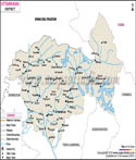
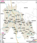
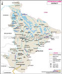
Pithoragarh is a beautiful district from the far east part of Uttarakhand in India. It is what many people call “Little Kashmir” for its beautiful snow capped peaks and green valleys. It is high in the mountain range and also has borders with Nepal and Tibet. Thus it is very important for travel and tourism.
If you are a fan of the great outdoors, Pithoragarh is your dream destination. From most parts of the town you can see the great Himalayas. There is a cool and fresh air, water that is as clear as crystal, and the people are very hospitable. Also it is the primary base which pilgrims use which are going on the famous Kailash Mansarovar Yatra.
History
Pithoragarh’s history is a story of mountain kings and brave warriors which also includes that of ancient trade routes. In the past the area was a part of the great Katyuri dynasty which at its peak ruled over most of the Kumaon hills. Those early rulers did found many stone temples and small settlements which we still see today. They settled in this valley which was flat, fertile and surrounded by high peaks which served as natural fortifications.
After the fall of the Katyuris, the land went into the hands of local chieftains which we know today as Rajwars. Out of which the most well known is the Pal dynasty who ran things out of a place called Askot. For that period in the history of Pithoragarh we see many small scale wars as various clans vied for control of the mountain passes. These passes which at the time were the only known trade routes between India, Tibet and Nepal were very much in demand.
In the 14th century the Chand kings of Kumaon rose to great power and took over the Soar Valley. It was they who developed the town which we see today. One of their kings which we know as Prithvi Gosain built a large fort on a hill top. This is how the name came to be Prithvigarh which over time turned into Pithoragarh. The fort was a symbol of their power and also served to protect the valley from foreign invaders for hundreds of years.
In the late 1700s the history of Pithoragarh took a turn as the Gorkhas from Nepal crossed over the Kali River into the area. These were tough warriors which ran the region very harshly for over 25 years. You can still see the old Gorkha fortifications on the ridges above the town. That rule came to an end when the British East India Company defeated the Gorkhas in the Anglo-Gorkha War of 1815 which in turn put the district under British control.
During the British time Pithoragarh became an important frontiers post. They improved the mountain paths which we may call proper roads thus enabling the army to quickly move towards the borders. After India won independence in 1947 Pithoragarh was a part of the Almora district. It was only on 24th February 1960 that it became a separate district which was done to improve the lot of the people living in high mountains and to provide them better facilities.
Today every local in the area looks up to the past of Pithoragarh. As you walk the old markets or visit the stone temples you are walking in the past of kings and pilgrims. The town has grown out of a small group of forts into a dynamic mountain city but it still has that feel of the past which is very much present in the cool mountain air.
Culture
The culture in Pithoragarh is a mix of mountain and very deep spiritual elements. As it is located at the periphery of Nepal and Tibet the culture here is a mix of Kumaoni and high altitude tribal heritage. The people which are known as Kumaonis are known for their honest nature, simple way of life and also for great physical strength which they require to live in the steep Himalayan terrain.
In Pithoragarh culture what you see is a great devotion to the local gods and goddesses. Almost each hilltop has a small temple which is a home to a deity that looks after the forest or the village. Also it is common to see “Nanda Devi” worshiped with great passion as she is looked upon as daughter of the Himalayas. What we find is that these religious gatherings are not for just prayer, but also for the whole community to come together and celebrate through song and dance.
In many aspects of their culture what really stands out is the folk music and dance. We see large scale dances like the Jhora and Chanchari which are very popular among men and women who hold hands and circle around. They perform songs which speak of bravery, love, and the beauty of the snow covered mountains. At these festivals the sound of the Hurka (a small drum) fills the valley which brings the whole of Pithoragarh culture to life and energy.
In this region we have the Kandali Festival which is very special. It occurs once in 12 years and is celebrated by the Shauka or Bhotia tribes. It marks a past victory which was won by women through use of their courage against invaders. At the festival people wear colorful traditional clothes and stage mock battles which they put on to display their respect for history and their women’s strength.
Art is present in all homes through a practice which is Aipan. This is a traditional folk art in which women practice of using red clay and white rice paste to create beautiful geometric designs. They decorate the floors, walls, and doorsteps of their homes at weddings and pujas. This art is handed down from mothers to daughters which in turn keeps the visual culture of Pithoragarh alive for each new generation.
In other words, the people of this district live in peace with the giant mountains that surround them. They honor the trees, the water, and their old traditions more than anything else. Though now more are going to the cities the culture of Pithoragarh is still at the core of what local people value.
Language
In Pithoragarh language is a sweet and rhythmic part of life in the high Himalayas. The primary dialect which the local people speak is Kumaoni. It is an old language which is a part of Indo-Aryan family.
Kumaoni is the language that resonates with our heart, as far as the official language goes in Pithoragarh we speak Hindi. It is used in schools, at government offices, and for news. In the district most people are able to use both Hindi and Kumauni which very well. This makes it a smooth experience for travelers from the plains to chat with local shopkeepers and guides without issue.
At the top of the district at the borders of Tibet and Nepal you will hear different tribal languages. The Shauka and Bhotia communities have their own unique dialects like Runglo. Also it is amazing to see how the language of Pithoragarh changes as you gain altitude into the snow covered mountains.
Many young people today are also taking up English to support the growing tourism industry. But what truly is the heart of this region is in its local folk songs and in poems written in Kumaoni. These poems and songs preserve the ancient traditions for the next generation. Here people’s way of speaking is warm and welcoming just like the mountain sunshine.
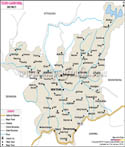
Geography
Pithoragarh is a green oasis which does indeed present itself surrounded by a range of snow capped mountains. In the Doon Valley within the Kumaon hills of Uttarakhand it is located. At an altitude of 1,645 meters above sea level this district is also what makes it a very important location as it borders with Nepal and Tibet.
In Pithoragarh’s geography the most prominent feature is the view of the high Himalayan peaks. In almost any part of the district you will see the five Panchachuli peaks which are a sight of silver crowns. Also present are huge mountains like Nanda Devi and Trishul. These great walls of rock and ice produce cool and fresh air which is felt all through the year including in the hot summer months.
Pithoragarh’s geography is home to some of the world’s most famous glaciers. The Milam Glacier and the Namik Glacier are like large ice rivers which have been there for thousands of years. People often travel to this area just for a trek up to these ice areas. Also these glaciers are the sources of many rivers which in turn flow down to the plains to water for millions of people.
In the mountainous terrain which is so variable in topography the flora changes with altitude. In the valleys we see dense stands of Pine and Oak. As you go higher the trees become smaller until you reach the “Bugyals” which are high altitude grassy meadows. These meadows which are like natural green carpets are the preferred locations for local shepherds to put their sheep out to summer pasture.
In Pithoragarh’s geographic area the soil and rocks are also very different. The mountains are of limestone and slate which in turn have created many a hidden caves and waterfalls in the forest. Although the land is very steep which does not suit large scale farming, the local people have developed beautiful step-farms on the sides of the hills. These terraces enable them to grow rice, ginger, and oranges in a very smart way.
This area is a mix of very high peaks, deep river valleys and vast green meadows. We see power and great beauty in every natural element. As you look at the snow capped peaks or the swift blue rivers the geography of the district will amaze any visitor to this part of the world.
| Facts of Nainital District | |
|---|---|
| State | Uttarakhand |
| District | Pithoragarh |
| Area (km2) | 7110 |
| Currency | Indian Rupee (INR) |
| Religion | Mostly Hinduism |
| Language | Hindi, Kumaoni |
FAQs
Q1: Which of the great Himalayan peaks can be seen from Pithoragarh?
The greatest known view is of the Panchachuli peaks, a set of five snow covered mountains which look like chimneys. Also on very clear days you may see other huge peaks like Nanda Devi, Rajramba, and Trishul from many points in the district.
Q2: What is the unique "Kandali" festival?
The Kandali festival is a once in a twelve year event for the Rung tribe. It is a tribute to local women who repelled invaders which includes a ritual of what is called the destruction of the Kandali shrub to mark victory.
Q3: What is Aipan and where can I find it?
Aipan is a heritage craft in which women paint white geometric designs on red clay which is a practice you see in the front of almost every home and in prayer rooms at weddings and festivals.
Last Updated on : May 08, 2026
| Buy this Map |