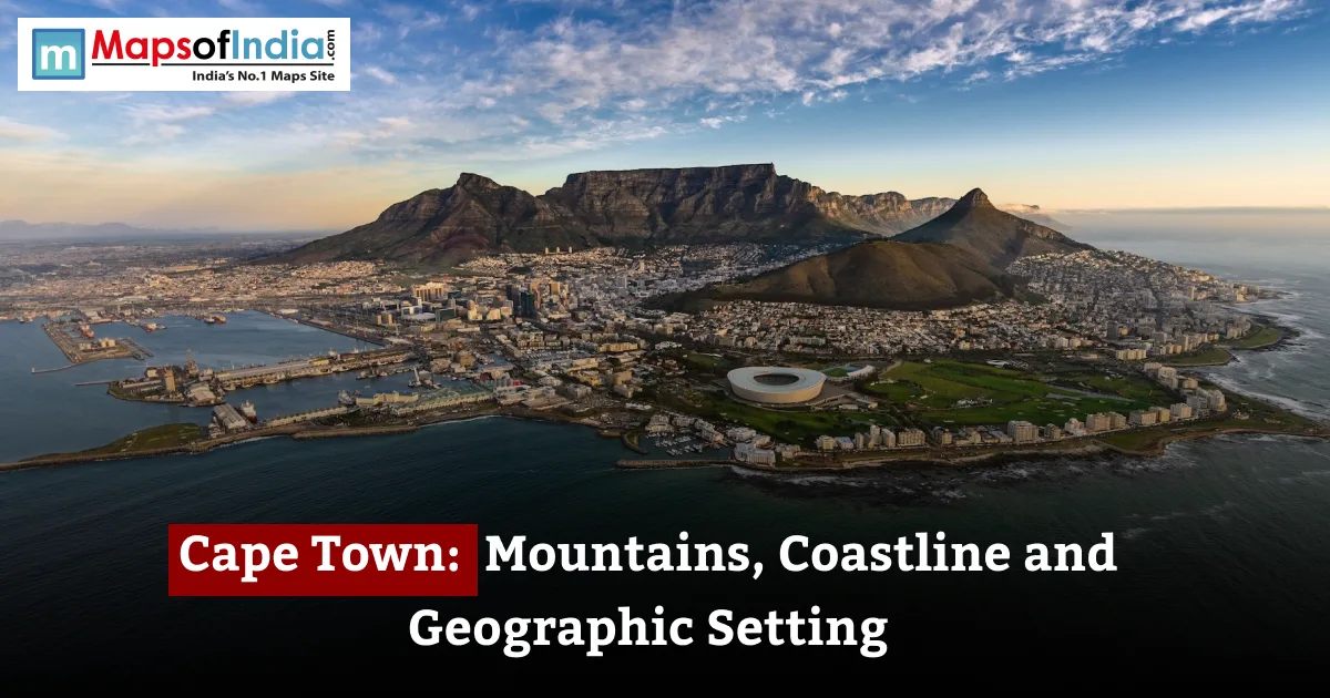
Cape Town lies on the tip of Africa, on the Cape Peninsula, where impressive mountains come together with the sea. Table Mountain is above the city, while Table Bay is to the north and False Bay is to the southeast. This mix of a peninsula, different coastlines, and surrounding lowlands gives Cape Town a special geographic situation.
Key Facts
- Country: South Africa
- Province: Western Cape
- Location: edge of Africa on the Cape Peninsula, not Table Mountain: Macleary's Beacon, 1,086 metres
- Major water bodies: Atlantic Ocean and False Bay
- Protected landscape: Table Mountain National Park
- Climate: Mediterranean with dry summers and wet winters.
Where is Cape Town Located?
Cape Town is located at 33.9°S, 18.4°E on the southwestern coast of South Africa. The city lies on the Cape Peninsula, with Table Bay and the Atlantic Ocean to the west and north, and False Bay to the southeast. The Cape of Good Hope and Cape Point are south on the peninsula.
Cape Town is sometimes said to be near where the mountains and Indian Ocean meet. However, the recognized geographic line between the two oceans is further southeast at Cape Agulhas, not at Cape Point or the Cape of Good Hope. This line is a rule, not a visible line in the water.
The Mountains That Frame Cape Town
Cape Town's environment is strongly shaped by the mountains that surround its area. Table Mountain is the well-known feature, while Devil's Peak and Lion's Head help create the natural mountain area around the City Bowl.
Table Mountain and the Table Mountain Chain
Table Mountain is a topped sandstone mountain that forms the northern end of the Cape Fold mountain range. Its top area is three kilometres long, while Maclears Beacon reaches about 1,086 metres, making it the highest point on the mountain.
The mountain's unique shape is related to its geology. Hard layers of sandstone have resisted erosion and the surrounding rock leaving the elevated,flat area that is visible in the city skyline. Clouds that move over the top during strong southeasterly winds create the well-known "tablecloth" effect.
Devil's Peak and Lion's Head
Devil's Peak rises to 1,000 metres and is to the east of Table Mountain and part of the mountain wall that looks over the city. Lion's Head, which is 669 metres, lies to the northwest and serves as another well-known landmark above the Atlantic Seaboard.
With Signal Hill, these peaks help form the mountainous area around central Cape Town. The mountains also shape the city's development by focusing built-up areas in valleys, coastal areas and flatter land around the mountain system.
Signal Hill and the City Bowl
Signal Hill extends westward from Lion's Head. It looks over the city centre, Table Bay, and Robben Island. The surrounding peaks form what is called the City Bowl, an enclosed urban area between the mountains and the sea.
This geography explains why the skyline of Cape Town is mainly shaped by features: the central city is in a limited space between Simon's Mountain slopes and Table Bay.
Cape Town's Coastline: Two Oceans, Shores
Cape Town's coastline changes a lot around the peninsula. The Atlantic Seaboard is open to the ocean while False Bay is more protected by the shape of the Cape Peninsula.
The Atlantic Seaboard
The Atlantic side includes areas like Camps Bay and Clifton and goes around the western side of the peninsula. Here the mountains often descend sharply toward the sea, creating coastal areas and beaches backed by steep slopes.
The Atlantic coastline is exposed to ocean waves. Usually has more wave energy than False Bay. The mix of mountains and sea creates some of Cape Town's special coastal views.
False Bay and the Indian Ocean Side
False Bay is the side of the Cape Peninsula. Places like Muizenberg and Simon's Town are along this side of the peninsula.
False Bay is wider and more protected than the Atlantic-facing coastline. Its enclosed shape creates different coastal conditions with less wave energy than the more exposed Atlantic Seaboard.
The two sides therefore have different coastal environments: the Atlantic side is more directly exposed to waves while False Bay has more protected coastal conditions.
Cape Point and The Cape of Good Hope
At the end of the peninsula are Cape Point and the Cape of Good Hope. These dramatic headlands mark the change from the built-up northern part of the peninsula to a mostly protected area within Table Mountain National Park.
Cape Point should not be confused with Cape Agulhas, which is further southeast and is the recognized meeting point of the Atlantic and Indian Oceans.
The Cape Peninsula: A Mountainous Finger into the Ocean
The Cape Peninsula is a long, narrow mountainous part that extends south from the Cape Town metropolitan area. The mountain chain runs along its spine, with Table Mountain near the end and Cape Point at the southern tip.
The peninsula is 60 km long within the protected landscape mentioned in UNESCO's World Heritage information. Its mix of mountains, cliffs, beaches and coastal vegetation creates a varied landscape within a small area.
Cape Town developed at the end because Table Bay offers a natural harbour. The bay gave ships a place to anchor on sea routes around the southern tip of Africa, while the surrounding mountains and coast shaped the city's growth.
Beyond the Cape Peninsula: Cape Flats Cities and Surrounding Landscape
The Cape Peninsula is not alone. It connects to the mainland of Cape Town through the Cape Flats, a large flat sandy coastal plain.
The Cape Flats are a geographical transition between the mountainous peninsula and the mainland. The flat land offered more space for building than the steep slopes around the City Bowl.
Beyond the Cape Flats, the land rises toward the mountain ranges and valleys of the Western Cape, including the Winelands around Stellenbosch, Paarl and Franschhoek. This creates a geographical difference between Cape Town's coastal town, the low sandy plains and the inland valleys.
How Geography Shapes Cape Town's Climate and Weather
Cape Town has a Mediterranean climate with warm to dry summers and cool, wetter winters.
The city's weather is strongly influenced by its location to the Atlantic and the surrounding mountains. The cold Benguela Current along the west coast adds to the marine influence, while the city's mountains affect local wind and cloud patterns.
In summer, the southeasterly wind called the Cape Doctor can become very strong. The familiar "tablecloth" of clouds over Table Mountain is connected to this wind as moist air rises against the mountain.
In winter, northwesterly winds associated with passing fronts bring most of the area's rain.
Biodiversity: Cape Town's Protected Landscapes
Cape Town's geography is important because it is in the Cape Floristic Region, one of the world's places for plant diversity and species that are found nowhere else. UNESCO says the Cape Floral Region is one of the plant areas in terms of size, with very high levels of species that are unique to the area.
Much of the peninsula is protected in Table Mountain National Park, where fynbos is the main type of plant life. Fynbos is a type of plant system that is adapted to the region's Mediterranean climate, poor soils, and regular fires.
The Cape Floral Region Protected Areas were listed on the UNESCO World Heritage List in 2004. This protected the fynbos plants and the natural processes that have made this region so diverse.
How Geography Influenced Cape Town's History and Growth
Cape Town's location made it important because of its position on sea routes around Africa. Table Bay offered a place to dock ships, while the peninsula and surrounding mountains provided a special physical setup for living.
The mountains also affected how the city grew. Areas around the City Bowl are limited by slopes, while the flat Cape Flats gave much more space for development. The result is a city whose shape is based on its geography rather than a flat, coastal area.
Robben Island, which is in Table Bay, also became part of this geography. Its offshore position made it historically important while still being close to Cape Town's harbour and coastal area.
Conclusion
Cape Town's geography is shaped by the connection between mountains, sea and lowland lands. Table Mountain and the Cape Peninsula shape the city's oceans, while the Atlantic coast, False Bay and the Cape Flats create physical areas. Together, these features explain a lot about Cape Town's landscape, weather and variety of life.
FAQs
Where is Cape Town located?
Cape Town is located on the coast of the Atlantic Ocean in the Western Cape province. The city is in the part of the Cape Peninsula, between Table Mountain and Devil's Cape, with False Bay to the southeast. Its approximate coordinates are 33.9°S, 18.4°E. Cape Town is on the Atlantic Ocean.
How high is Table Mountain?
The highest point of Table Mountain is Maclears Beacon, 1,086 metres above sea level. The mountain is a flat-topped sandstone feature that looks over central Cape Town and is part of the Cape Fold Mountain Range.
What mountains are around Cape Town?
The main mountains around Cape Town include Table Mountain, Devil's Peak, Lion's Head and Signal Hill. Table Mountain reaches 1,086 metres at Maclears Beacon, while Devil's Peak is about 1,000 metres and Lion's Head is about 669 metres.
Do the Atlantic and Indian Oceans meet at Cape Town?
No. Cape Point and the Cape of Good Hope are not the meeting point of the Atlantic Ocean and the Indian Ocean. The recognized boundary is at Cape Agulhas, farther southeast of Cape Point. The boundary is a convention rather than a visible line in the water.
Why does Cape Town have a Mediterranean climate?
Cape Town has a Mediterranean climate because its southwestern location experiences summers and wetter winters. The surrounding Atlantic Ocean moderates temperatures, while seasonal wind systems and the city's terrain influence local weather. The region's winter rainfall and summer dryness are characteristic of Mediterranean climates.
What is the Cape Peninsula?
The Cape Peninsula is the projection of land extending south from Cape Town toward Cape Point. Its spine contains the Table Mountain massif and other peaks, while its sides are bordered by the Atlantic Ocean and False Bay. The peninsula forms the mountainous setting of Cape Town.