Imagine living in a country where towering volcanoes rise above lush green landscapes, earthquakes occasionally shake the ground, and some of the world's most powerful geological forces are constantly at work beneath the surface. This is Indonesia, an archipelago whose spectacular geography is closely tied to its location along the Pacific Ring of Fire.
Indonesia is an archipelago with over 17,000 islands and is located in a seismically active region at the plate boundaries. This makes it one of the most volcanically and seismically active areas of the Earth. Its volcanoes have formed mountains and islands, fertile agricultural soils and have brought tourists from all over the world. Meanwhile, millions of people in the country are exposed to earthquakes, volcanic eruptions and tsunamis due to the country's tectonic setting.
Thus, why is Indonesia geologically active and why does it have many volcanoes?
What Is Indonesia’s Ring of Fire?
A great horseshoe-shaped area around the Pacific Ocean is called the Ring of Fire. It is located in the Americas, Asia and Oceania and corresponds to a high percentage of the world's earthquakes and active volcanoes.
One of the most active parts of this geological belt is in Indonesia. Rather than being a simple circle of volcanoes, the Ring of Fire is essentially a network of tectonic plate boundaries where Earth's crust is constantly moving.
One of the most important processes here is subduction. In simple terms, subduction happens when one tectonic plate is pushed beneath another. As the descending plate moves deeper into the Earth, geological processes can contribute to the formation of magma. Some of this magma eventually rises toward the surface and can feed volcanoes.
The region's location in the middle of the major subduction zones has therefore been a major contributor to the formation of Indonesia's unique volcanic topography.
Why Does Indonesia Have So Many Volcanoes?
Indonesia's volcanoes are mostly created due to the collision of various tectonic plates, such as the Indo-Australian plate, Eurasian plate, other plates, and small blocks in the region.
The Indo-Australian plate is being thrust under the plates to the north along the southern and western edges of Indonesia. This enormous zone of tectonic activity stretches along the country's western and southern island chains.
Throughout millions of years, there have been repeated volcanic eruptions that have formed mountains, volcanic cones and whole island landscapes. This is why volcanic peaks are such a prominent feature of places such as Sumatra, Java, Bali, Lombok, Sumbawa and Flores.
Indonesia is one of the most volcanic countries in the world, with over 100 active volcanoes.
Famous Volcanoes That Define Indonesia
Indonesia's volcanoes are not merely geological features; many have become symbols of the country's landscape.
Mount Merapi, located on Java, is one of Indonesia's most active volcanoes. It is especially critical to monitor its activity in populated areas.
East Java rises up to Mount Semeru further east. It is at a height of 3,676 metres, making it the highest mountain of Java and also an active volcano.
Mount Bromo is another iconic volcanic scenery in Indonesia. Its expansive volcanic landscape has earned it a place in tourism, and it is within the Bromo Tengger Semeru National Park.
Mount Agung is the island's main attraction in Bali. In other words, Mount Rinjani, which is located in Lombok, is well known for its magnificent volcanic crater and the lake located in the crater.
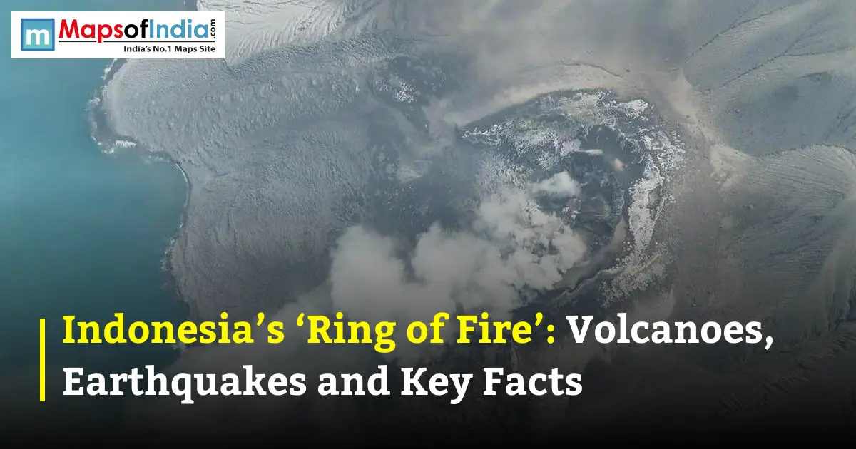
In the Sunda Strait between Java and Sumatra, there is a more famous historical story about Krakatau; perhaps no Indonesian volcano has it. In 1883, it erupted catastrophically, making it one of the best-known volcanic events of modern times.
Indonesia Is Also an Earthquake Hotspot
The geology of Indonesia is only half the story.
The same tectonic processes which contribute to the formation of volcanoes also contribute to Indonesia's susceptibility to earthquakes. When tectonic plates slide against each other, under each other or alongside each other, the stress in the Earth's crust can be immense. An earthquake is when this stored energy is suddenly released.
In Indonesia, earthquakes occur both on land and under the sea. Large movements of the seafloor caused by undersea earthquakes can also move the seawater and cause tsunamis.
The most devastating was the earthquake in northern Sumatra on 26th December, 2004, which produced a tsunami in communities around the Indian Ocean. It killed, and left many people in several countries and has been one of the deadliest natural disasters in history.
How Have Volcanoes Shaped Indonesia?
Volcanoes can be a significant threat in Indonesia, but they have also shaped the landscapes that are critical for the communities living in the country.
Volcanic eruptions release ash and other materials which may later form useful nutrient-rich soils. These fertile areas have been used for agriculture for centuries, especially on the overpopulated island of Java.
Additionally, volcanoes have fashioned unusual rock formations, rugged peaks, volcanic valleys and crater lakes.
This geology has resulted in volcanoes becoming an important part of the tourism industry in Indonesia. Mount Bromo, Mount Batur and Mount Rinjani are some of the local destinations that visitors like to visit to enjoy the volcanic landscape, hiking trails and the dramatic sunrise.
Why Do People Live Near Active Volcanoes?
Living by a volcano can seem a little bizarre to start with. However, there are many opportunities in volcanic regions in Indonesia.
The use of fertile soils for agriculture, mountains for water resources, and opportunities for tourism. Many communities have also coexisted in harmony with volcanoes for centuries and acquired local knowledge of topography and hazards.
However, the risks remain significant. A volcano can remain relatively quiet for years before showing signs of renewed activity. For this reason, Indonesia places considerable emphasis on volcanic monitoring and disaster preparedness.
How Indonesia Monitors Its Volcanoes
Scientists continuously monitor Indonesia's active volcanoes for changes that could indicate increasing activity. Monitoring can include earthquake measurements, ground deformation, volcanic gas observations, satellite imagery and visual observations.
When volcanic activity changes, authorities can raise alert levels and establish exclusion zones around dangerous areas. If the risk becomes severe, communities may be evacuated.
These measures cannot prevent an eruption, but they can provide valuable time for authorities and residents to respond.
Indonesia’s Ring of Fire: Key Facts
Feature | Key Fact |
| Location | Southeast Asia |
| Geological setting | Pacific Ring of Fire |
| Major geological process | Tectonic plate subduction |
| Active volcanoes | More than 100 |
| Major volcanic islands | Sumatra, Java, Bali and the Lesser Sunda Islands |
| Famous volcanoes | Merapi, Semeru, Bromo, Agung, Rinjani and Krakatau |
| Major hazards | Volcanoes, earthquakes and tsunamis |
| Historic volcanic event | Krakatau eruption, 1883 |
| Major earthquake-tsunami disaster | Indian Ocean earthquake and tsunami, 2004 |
A Country Shaped by Fire and Movement
Indonesia's Ring of Fire is more than a geographical term. It explains much of the country's physical landscape and helps us understand why Indonesia has towering volcanoes, frequent earthquakes and spectacular volcanic islands.
Beneath the forests, cities and agricultural fields, tectonic plates continue their slow but powerful movement. That movement has created some of Indonesia's most beautiful landscapes while also producing natural hazards that can have devastating consequences.
From the smoking slopes of Mount Merapi to the dramatic caldera of Mount Rinjani and the historic legacy of Krakatau, Indonesia offers a remarkable glimpse into the restless nature of our planet.
Its Ring of Fire is ultimately a story of both creation and destruction, a geological force that has shaped Indonesia for millions of years and continues to shape its future.
FAQs
1. Why is Indonesia called part of the “Ring of Fire”?
Indonesia lies along major tectonic plate boundaries where intense geological activity causes frequent earthquakes, volcanic eruptions and other seismic events. This is why Indonesia is commonly associated with the Pacific Ring of Fire.
2. How many active volcanoes does Indonesia have in 2026?
Indonesia has 127 active volcanoes, making it one of the most volcanically active countries in the world. Many of these volcanoes are closely monitored because of the risks they pose to nearby communities.
3. Why does Indonesia have so many volcanoes?
Indonesia is located at the meeting point of several tectonic plates. As one plate moves beneath another in a process called subduction, magma can rise toward the surface, creating chains of volcanoes across islands such as Sumatra, Java and the Lesser Sunda Islands.
4. What is happening with Anak Krakatau in Indonesia in 2026?
Anak Krakatau has been experiencing renewed eruptive activity in September 2026, producing ash and volcanic emissions. Its activity has also disrupted air travel and prompted authorities to maintain safety restrictions around the volcano.
5. Which Indonesian volcanoes are currently under close monitoring?
Indonesia closely monitors numerous active volcanoes, including Anak Krakatau, Mount Merapi, Mount Semeru, Mount Lewotobi Laki-laki and Mount Sinabung. Their activity levels can change, so authorities continuously monitor earthquakes, volcanic gases, ash emissions and other warning signs.
6. Why does Indonesia experience frequent earthquakes?
Indonesia experiences frequent earthquakes because it lies near several active tectonic plate boundaries. The movement and interaction of these plates can release large amounts of energy, producing earthquakes both on land and beneath the surrounding seas.
7. Can volcanic eruptions in Indonesia cause tsunamis?
Yes. Under certain conditions, volcanic eruptions, underwater activity or the collapse of part of a volcanic island can generate tsunamis. Indonesia has experienced deadly volcanic tsunamis in the past, including the tsunami triggered by the collapse of Anak Krakatau in 2018.