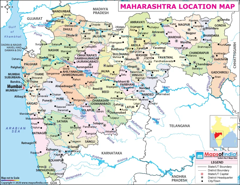
Maharashtra is located in the western part of India, along the Arabian Sea. It is one of the country's largest states by area and has a prominent position in India's economic, industrial, and transportation networks. Mumbai, the state capital, is India's major financial centre, while Nagpur serves as the winter capital of Maharashtra. The state's geographical setting extends from the Konkan coastline across the Western Ghats to the Deccan Plateau, creating a diverse landscape with distinct climatic and economic regions.
Geographical Position of Maharashtra
Maharashtra lies approximately between 15°36′ N and 22°02′ N latitude and 72°36′ E and 80°54′ E longitude. It covers an area of around 307,713 square kilometres, making it the third-largest Indian state by area. Its location in western India gives it access to the Arabian Sea and connects it with the country's central and southern regions.
The state has a varied physical landscape. The narrow Konkan coastal strip runs along the Arabian Sea, while the Western Ghats rise inland, forming a major geographical barrier. Beyond these mountains, the Deccan Plateau covers a large part of Maharashtra. Its terrain includes fertile river valleys, basaltic plateaus, forested hills, and agricultural plains.
Which States Border Maharashtra?
Maharashtra shares its boundaries with six Indian states and one union territory. Gujarat lies to the northwest, Madhya Pradesh to the north, Chhattisgarh to the east, Telangana to the southeast, Karnataka to the south, and Goa to the southwest. The union territory of Dadra and Nagar Haveli and Daman and Diu is situated near its northwestern side. The Arabian Sea forms the state's western coastal boundary.
These geographical connections make Maharashtra an important link between western India and the country's central and southern regions. Its extensive road and railway networks connect major commercial centres, industrial zones, ports, and agricultural markets.
Major Rivers and Physical Features
Maharashtra's river systems play a significant role in its agriculture and water supply. The Godavari, often called the Dakshin Ganga, originates near Trimbakeshwar in Nashik district and flows eastward across the Deccan Plateau. The Krishna, Bhima, Tapi, and Wardha are other important rivers associated with the state.
The Western Ghats influence rainfall distribution across Maharashtra. The Konkan coast receives heavy monsoon rainfall, whereas parts of the interior plateau experience comparatively lower precipitation. This variation affects farming patterns, water availability, vegetation, and settlement distribution. The state also contains important hill stations, forests, and protected wildlife areas.
Why Is Maharashtra's Location Important?
Maharashtra's position along India's western coast supports domestic and international trade. Mumbai and the Jawaharlal Nehru Port near Navi Mumbai are important components of the state's maritime infrastructure. The state also has major industrial and commercial centres, including Pune, Nashik, Nagpur, Chhatrapati Sambhajinagar, and Thane.
Agriculture remains important in rural areas, with crops such as sugarcane, cotton, soybeans, and pulses grown in different regions. At the same time, Mumbai's financial institutions, Pune's technology and automobile industries, and the state's manufacturing and logistics networks contribute substantially to the Indian economy.
Maharashtra's location combines coastal access, plateau agriculture, mineral resources, and extensive transport connections, giving it a distinctive geographical and economic role in western India.