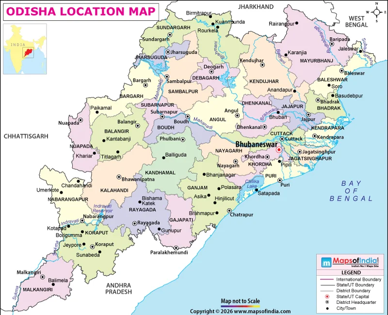
Odisha is located on the eastern seaboard of India facing the Bay of Bengal. It is at the confluence of the coastal plains, river basins, and Eastern Ghats in India, thus adding to its unique geographical identity. The state, which was once called Orissa, was a strategic state between West Bengal and Andhra Pradesh. Bhubaneswar, its capital, serves as the administrative centre, while Cuttack, Rourkela, and Sambalpur are among its other important cities.
Odisha's Position on the Map of India
On the map of India, Odisha appears along the eastern coastline, south of West Bengal and north of Andhra Pradesh. The State covers an area of approximately 17° 49′ N to 22° 34′ N latitude and 81° 27′ E to 87° 29′ E longitude. The area is approximately 155,707 square kilometres.
The geographical location of Odisha is in the eastern part of India and is close to the coastal region and mineral-rich interior region of India. The eastern edge borders the Bay of Bengal, and its western districts border the upland parts of central India. This transition from coastal lowlands to elevated terrain creates considerable variation in the state's physical landscape.
States Surrounding Odisha
Odisha shares land borders with four states – West Bengal in the North East, Jharkhand in the North, Chhattisgarh in the West and Andhra Pradesh in the South. It is bordered by the Bay of Bengal to the east.
These adjoining states are linked with various significant corridors in the region to Odisha. Its northern routes are connected to the mineral and industrial belts of eastern India and its southern routes to Andhra Pradesh. The movement of minerals and industrial goods is also supported by connections towards Chhattisgarh. The state of Odisha, situated on the coast, also enhances its connectivity with domestic and international sea trade.
Landscape and Major Geographical Regions
The geography of Odisha can be divided into three main physical regions, namely the coastal plains, the central tablelands and the mountainous highlands. The coastal plains are mainly made up of river deposits and have good land for farming and heavily populated villages. Further inland, there are plateaus and rolling uplands, and parts of the southern and western districts are covered by the Eastern Ghats.
The Mahanadi is one of the most important rivers of the State. The other prominent rivers are Brahmani, Baitarani, Subarnarekha, and Rushikulya. They have river basins that provide water for irrigation, agriculture, and local economies. The Mahanadi delta, in particular, is important for rice cultivation.
Odisha's natural geography also includes Chilika Lake, a large brackish-water lagoon along the coast, and extensive forest areas that support diverse wildlife.
How Odisha's Location Influences Its Economy
Odisha's position on the Bay of Bengal makes it important for port-based trade, fishing, and coastal industries. Paradip Port supports the transportation of bulk commodities and industrial materials. Inland, substantial reserves of iron ore, coal, bauxite, and chromite have encouraged mining, steel production, and other mineral-based industries.
The state's tropical monsoon climate supports agriculture, although coastal areas are vulnerable to cyclones and heavy rainfall. Its combination of maritime access, river systems, mineral deposits, and varied terrain makes Odisha an important contributor to India's industrial and agricultural economy.