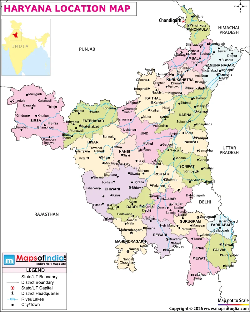
Haryana is located in the northwestern part of India, sharing its land borders with Punjab, Rajasthan, Delhi, and Uttar Pradesh, and is part of the huge Indo-Gangetic plains. It is also situated in close proximity to the national capital of India, New Delhi, and forms an integral link between the national capital and Punjab, Rajasthan, and other parts of North India. The formation of Haryana was an outcome of the reorganization of Punjab State on 1st November 1966. Its capital is Chandigarh and also the capital of Punjab. The state is significant for its geographical position and its fertile agricultural land and growing urban centres in the northern geographical belt of India.
Haryana's Location and Neighbouring States
Haryana lies to the south and southeast of Punjab and extends towards the plains bordering Uttar Pradesh. It is bordered by Punjab and Himachal Pradesh to the north, Rajasthan to the west and southwest, and Uttar Pradesh and Uttarakhand to the east and northeast, respectively. Haryana has close geographical and economic relationship with the National Capital Territory of Delhi as it is bounded by it on three sides.
The State's boundaries are roughly 27°39' to 30°55' north latitude and 74°28' to 77°36' east longitude. Haryana is a landlocked State with no coastline, covering an area of approximately 44212 square kilometres. It has a significant stretch along its eastern border with Haryana, the Yamuna River, which borders Uttar Pradesh.
Haryana is an important transit area as it lies between the major urban centres of northern India. The towns and cities are linked to Delhi, Chandigarh, Jaipur and other commercial centres by national highways, expressways and railway lines.
Landscape and Natural Geography of Haryana
Haryana's terrain is largely composed of level plains, which are suitable for intensive farming. These plains are part of the northern Indian alluvial plain, which is created by the action of river systems and deposits over time. The state's geographical features are agricultural. Crop cultivation includes wheat, rice, mustard, cotton, and sugarcane.
There are no flat hills, however. The foothills of the Shivaliks are in the north-east of the state and parts of the Aravalli range are in the south. The western and south-western sections are generally dry in comparison to the eastern and north-eastern sections.
The river Yamuna is one of the most important rivers related to the geography of Haryana. The Ghaggar and Markanda are other notable river systems, although their water flow varies seasonally. Agriculture is practised in several districts by irrigating with canal water and groundwater supplies.
The summers are hot, and winters are relatively cold in Haryana. Haryana has hot summers, monsoon, and relatively cooler winters. There is great variability in rainfall distribution that affects the vegetation, farming activities and water management of the state.
Why Does Haryana's Location Matter?
The urbanization and rapid industrialisation in Haryana are due to its close proximity to Delhi. Gurugram is now a hub of information technology, corporate offices and financial services, and Faridabad is famous for its industrial activity. Panipat has a well-established textile and refining industry, while some other cities are engaged in manufacturing, trade, and processing of agriculture.
The State also has historical and cultural significance. Kurukshetra is related to the Mahabharata and is visited by religious circles, while the Sultanpur National Park is famous for its birdlife.
Overall, Haryana lies in a strategic place in the northwestern part of India, which includes fertile plains, rivers, and the availability of important economic centres. It is situated in close proximity to the city of Delhi and has its own transportation, agricultural, and industrial capabilities, which add to its significance in the country.