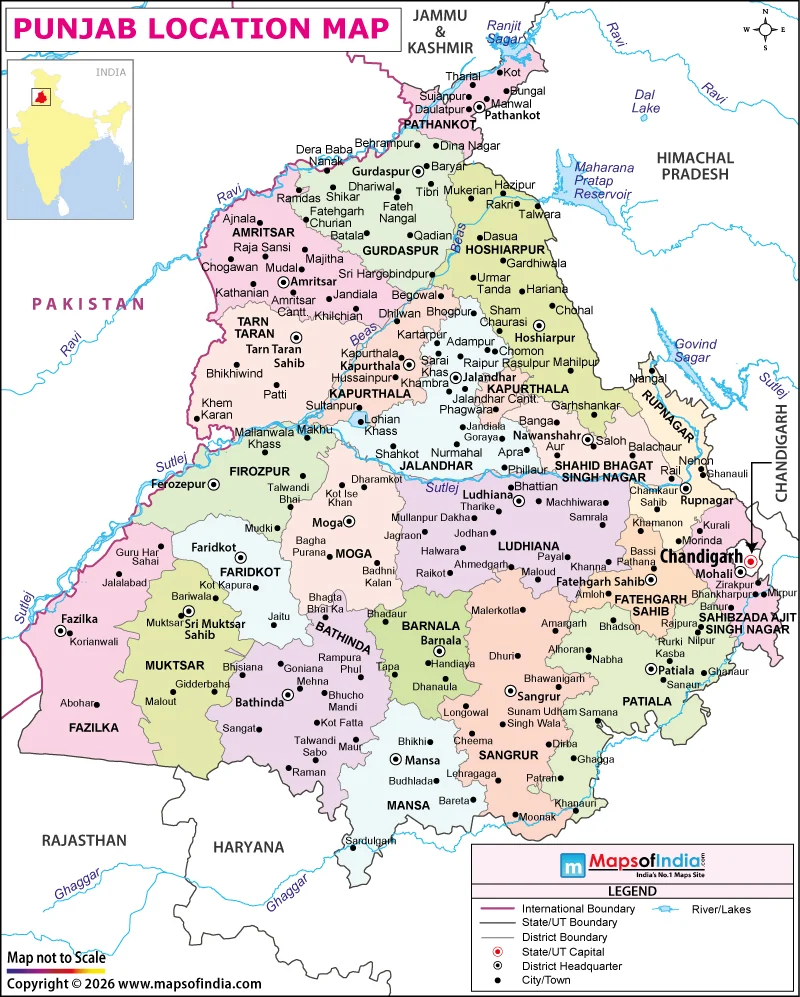
Punjab is situated in northwestern India, occupying an important position between the Himalayan foothills and the plains of the Indian subcontinent. It is bordered by Pakistan on the western side; Jammu and Kashmir to the north; Himachal Pradesh to the north and northeast; Haryana to the southeast; and Rajasthan to the southwest. The geographical location of this region has made Punjab an important region in the history of northern India.
Punjab's capital is Chandigarh, which is also the capital of Haryana. Among the major cities of the state are Ludhiana, Amritsar, Jalandhar, Patiala and Bathinda. Amritsar is in the north-western part of the state, and Amritsar district shares an international border with Pakistan, while Ludhiana is in the south-eastern part of the state and is one of the important cities and industrial centres of Punjab.
Punjab's Position in Northern India
The state is located in the northwestern part of India, along the foothills of the Himalayas and the international border with Pakistan. The plains, mostly level and fertile, constitute the major part of Punjab, while the Shivalik Hills are present at the north-eastern edge of the state. The Himalayan ranges extend farther north and north-east beyond the state.
Punjab lies within the Indus River basin, and its major rivers include the Sutlej, Beas and Ravi. Its terrain has been moulded by several rivers, including the Sutlej, Beas and Ravi rivers that run through or alongside sections of the Indian state. The area is characterized by its long history of intensive agriculture, which has been made possible by the fertile alluvial soils, rivers and irrigation systems.
The name Punjab itself is a testament to the relationship of the region with rivers. It is derived from Persian words that mean ‘land of five waters' and refers to the five major rivers that were historically known to be part of the larger Punjab: Jhelum, Chenab, Ravi, Beas and Sutlej. In present times, Jhelum and Chenab flow mainly through Pakistan, while the Ravi, Beas and Sutlej are the principal rivers associated with the Indian state of Punjab.
Why Punjab's Location Matters
Punjab's position near the India-Pakistan border has given it considerable historical and strategic significance. Over the centuries, the region has seen great migrations of people, goods, armies, and cultures. The Partition of 1947 divided the historic Punjab region between India and Pakistan and significantly changed its political and geographical boundaries.
Its physical setting is also a reason for the strong identity of agriculture among the people of Punjab. The alluvial flat plains have favourable soils, watercourses, and a wide irrigation network that allow crops to be grown, including wheat, rice, cotton, maize, and sugarcane. Punjab became one of the leading centres of India's Green Revolution, which significantly increased agricultural production in the state.
So on the map, Punjab can be seen as a northwestern state of India, sharing an international border with Pakistan and lying between the Himalayan foothills and the plains of northern India. Its rivers, fertile plains, neighbouring states, and position along an international frontier make it a distinctive part of India's geography.