


Life beats strong in Punjab, grounded in the earth of northwest India. Its name whispers old Persian - ‘panj’ meaning five, ‘ab’ standing for water - flowing together like tributaries. The land holds five great rivers: Sutlej leads, followed by Beas, then Ravi joins, Chenab follows close, and Jhelum lingers at the rear. Flowing water rules this place, pulling abundance out of wide, level stretches below. Where currents fan out, soil wakes up, feeding rows upon rows of grain without show or sound.
Older than memory, Punjab carries traces of riverbank settlements lost to time. Empire followed empire across its fields, each leaving quiet marks beneath the soil. Rule from distant thrones pressed down, yet whispers of resistance hum in village corners. Out of this mix rose a path started by Guru Nanak, whose words took root like trees along canals. His teachings settled into daily gestures - hands folded at dawn, voices rising before harvest. Strangers receive bread without questions asked. Labor continues under the sun that blisters metal. Bonds formed young stay strong, arms linked during festivals or funerals.
History
Not just where old trade paths met, Punjab holds traces of countless journeys made long ago. Westward in South Asia, its location pulled in soldiers, merchants, holy travelers - quiet imprints followed every arrival. Even when fought over again and again, the land kept core parts of who it was. Persian rulers came first, then warriors from central steppes; life changed slowly each time - speech, habits, faiths shifting like sand under wind. Time moved slow, yet changes piled up - customs layered one over another, much like silt gathering where water slows. Since the shape of the earth decided so much, what happened here kept shifting, always on the move.
Fringed by five broad rivers, far within Punjab, stood an early urban society - thriving from 2600 to 1900 B.C. At sites such as Harappa, remnants show thoughtfully planned roads, trade stretching afar, yet artifacts crafted with steady precision.
Now and then, groups speaking Indo-Aryan languages settled in Punjab after the old Indus cities disappeared. Shaping the Rigveda was one result of their presence - that text now gives clues about daily existence back then. Spiritual beliefs found a voice there, while glimpses into authority structures slipped between stanzas. Lines reveal customs, ranks, ways rulers acted. Much of our understanding rests on these aged hymns without saying so outright.
Around 600 B.C., control of the Punjab passed through many empires. Persia held sway there, part of the Achaemenid realm, until Alexander seized it in 326 B.C. After he left, everything changed fast - Chandragupta Maurya brought the land into the Mauryan Empire.
Falling apart opened space for Indo-Greek rule after the Mauryan decline, then Kushans took hold before Guptas claimed it. Culture bloomed again during those years even as markets changed direction slowly.
From the early Middle Ages onward, invasions rolled across the region - often pushed forward by forces out of Central Asia, like Mahmud of Ghazni, then later Muhammad of Ghor. These assaults reshaped authority bit by bit, steering leadership into Muslim hands until the Delhi Sultanate stood dominant. Rule continued shifting afterward, eventually blending into the wide sweep of the Mughal Empire. With their rise came greater stability; commerce grew stronger even as new structures climbed above urban streets.
A fresh path emerged in the region starting in the 1400s, sparked by Guru Nanak's arrival and his teachings. Because of him, ideas about justice, belief, and shared duty moved through generations. Over time, unity among Sikhs tightened - this became visible when figures such as Guru Gobind Singh stepped forward. In 1699, he formed the Khalsa, a turning point that reshaped everything.
Midway through the eighteenth century, as Mughal control faded, Sikh warrior bands slowly took hold throughout the region. Each of these factions - called misls - acted on its own at first. Yet gradually, unity emerged when leadership passed to Ranjit Singh. The early decades of the 1800s saw him shape a powerful kingdom based in Lahore. Out of that time came stable rule, strong military forces, yet a flowering of culture and customs too. His leadership stands remembered today - unlike much else around it - as a period when structure held firm even as turmoil spread nearby.
After Ranjit Singh passed away, arguments among court figures slowly cracked the kingdom open - which opened the door for the British East India Company to step in after the Anglo-Sikh Wars ended in 1849. Under British rule, Punjab grew into a central zone for governance and agriculture.
Waking up took time, then happened fast, when people began seeing things differently around the early 1900s. One event - gunfire at Jallianwala Bagh - changed what so many believed about British power. Anger moved from town to town, feeding resistance that kept coming back. Not everyone stood on stages; some simply said no when told to obey. Step by step, nameless and uncelebrated, they built something rulers had always overlooked.
After World War II finished, new borders sliced through South Asia, turning British India into two separate countries - India and also Pakistan. This change made huge numbers of people leave their homes, setting off clashes between groups that had shared neighborhoods before. In eastern Punjab, where flat fields bake beneath long summers, residents suddenly belonged to India. Time moved on. By 1966, government leaders redrew maps once more, forming newer states from older regions.
Culture
Everyday rhythms here carry echoes of Guru Nanak’s path, where living justly matters more than mere tradition. Because of this faith, sharing time at a meal means sitting shoulder to shoulder, no matter who you are. Inside every gurdwara, free food breaks walls that often separate people. The Golden Temple glows not only with gold but also as proof of unity held close through years. While dawn spreads across courtyards, silence later settles into stone steps soaked in collective hope.
Out comes laughter as festival time rolls in, faith dancing alongside harvest seasons. Ripe crops greet Baisakhi, a day rooted in Sikh tales of bold turns and resilience. Night glows with flames at Lohri, voices climb through cold air, boots hammer earth, frost loosens its grip. Crowds form - not pulled by rules but by beat, recollection, layers beneath speech.
Footsteps pound the earth just as drumskins tremble beneath flying sticks. Not far off, Bhangra surges ahead whereas Giddha shapes old whispers through sharp claps and turning bodies. Under wide light, farmers' memories bend into motion because happiness thrums in each stride across cracked land. Sound jumps from wood hitting hide - the dhol speaks long before voices rise. What grows from dirt appears again in arms lifted like sprouts, eyes meeting sideways, grins chasing floating grit.
Fresh greens simmered slowly give meals their deep taste. Because the land offers root vegetables, mustard leaves appear beside grilled flatbreads. Rich dairy arrives from nearby fields where cows feed on monsoon grass. When winter comes, sour buttermilk warms hands at dawn.
On top, turbans rest above flowing shirts and pants worn by men. Gatherings show women gliding in long tunics and trousers, covered with bright scarves. Patterns form when threads lock together, pulling attention. Bold colors rise during celebrations, stitched with care. Floating through the air, music wraps around moving figures in rituals thick with purpose. Step by step, weddings stretch out, built on traditions carried forward through family lines.
Language
Sitting at the crossroads of empires, Punjab’s words carry layers built slowly over time. Not just one influence but waves - first traders, then rulers - etched meaning into everyday speech. Though rooted in ancient Indo-Aryan soil, its voice shifted under foreign footsteps. Dialects mixed quietly, now leaning toward Persian rhythm, now echoing Arabic tones. Later came English, slipping in through schools and laws, altering flow without force. Change didn’t arrive all at once - it settled like dust after long travel.
One version we see now ties deeply to the Gurmukhi letters shaped by Guru Angad during the 1500s. Because of this writing, sacred lessons stayed intact - especially the words gathered in the Guru Granth Sahib. As people shared beliefs more easily through these characters, they also built a unique way of life across the land. From that time on, the symbols did more than carry meaning - they held community together.
Long ago, old tongues like Sanskrit and Prakrit shaped how people spoke here, leaving marks on words and sentence patterns. Because of contact with Persian-speaking leaders in the Middle Ages, new phrases for government and books entered daily talk. You can hear those traces now, whether someone is chatting or reading poetry aloud. When foreign powers took control later, school and official business started using English more often. That shift wove yet another thread into the way language lives here today.
Geography
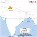
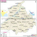
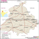
Flat farmlands shape Punjab's layout, fed by wide rivers and tucked into northwest India. This stretch belongs to the vast Indo-Gangetic plain, where deep silt soils support strong farm yields. Over time, five main streams - the Sutlej, Beas, Ravi, Chenab, and Jhelum - carved the terrain; that’s how it got its name. Nowadays, just a few of those rivers run through Indian Punjab, the rest crossing beyond into Pakistan.
Flat land stretches across most of the area. Because it is so level, farming spreads easily here - water channels also form without much trouble. River movements over hundreds of years left behind rich soil, ideal for growing things like wheat, rice, and sugarcane. Canals run wide through the fields, fed mostly by the Sutlej and Beas, pushing more growth into each season's harvest. Thanks to these flows, this place pumps out huge amounts of grain for the country every year.
Hot summers show up with long dry stretches, yet heat keeps building steadily. Cold settles in during winter months, especially when fog rolls through overnight. Rain arrives mainly from June onward, lasting till September's edge. Most yearly moisture drops then, filling fields but also pooling where land dips lower.
Most native plants here gave way to farmland long ago, thanks to widespread crop cultivation. Still, bits of woodland hang on, especially near rivers or inside conservation zones. Lately, some work has gone into restoring tree coverage, tackling issues like worn-out soil and sinking water tables brought by heavy farming.
Sitting where it does, the region touches Pakistan along a stretch of open land. That spot on the map shaped how towns rose, what jobs took root, even how roads got built. Amritsar pops up first when talking commerce, then comes Ludhiana - both keep goods moving, machines running, people traveling.
Punjab State Information | |
|---|---|
| Capital | Chandigarh |
| Date of formation | 1 November 1966 |
| Governor | Gulab Chand Kataria |
| Chief Minister | Bhagwant Mann |
| Tourist attractions | Golden Temple, Jallianwalla Bagh, Rock Garden, and so on. |
| Festivals | Lohri, Baisakhi, Gurpurab |
| Major dance and music forms | Bhangra and Gidda |
| Arts and crafts | Phulkari or flower embroidery; wood inlay of Hoshiarpur on black shisham wood. |
| Languages | Punjabi |
| Size | 50,362 km2 (19,445 sq mi) |
| Population (Census 2011) | 27,704,236 |
| Rivers | Beas, Sutlej, Ravi, |
| Forests and wildlife sanctuaries | Bir Moti Bagh, Bir Bhunderhari, Bir Dosanjh |
| State animal | Blackbuck |
| State bird | Baaz (Accipiter gentilis) |
| State tree | Shisham |
| Major crops | Wheat, gram, barley, oil seeds |
| Factoids | Sikhism, founded by Guru Nanak, is a dominant religion in Punjab. The word 'Sikh' means a 'learner'. |
| The first person to give Punjab its independence was Banda Singh Bahadur. | |
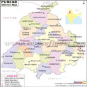
| No. of District | 23 |
FAQs
Q1: When should you go to Punjab?
Visiting from October through March works best because temperatures stay mild enough for walking around. When winter arrives, expect a chill in the air instead of heat. Summer shows up with strong sun, making outdoor plans harder.
Q2: Is Punjab Safe for Tourists?
Punjab tends to welcome visitors without issue. Friendly faces greet most travelers, yet common sense on the road never hurts. Staying alert matters just as much as enjoying warm welcomes.
Maps in Other Regional Languages
MOI.AB.28.01.17
Last Updated on: May 08, 2026