


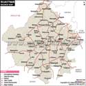
Rajasthan Map
The Rajasthan Map provides a detailed representation of India’s largest state by area, highlighting its districts, cities, rivers, administrative divisions, and geographical features. Located in northwestern India, Rajasthan is known for its royal heritage, desert landscapes, historic forts, colourful culture, and diverse geography. A Rajasthan map is useful for understanding the state’s location, district distribution, major cities, and important physical features.
Rajasthan
Rajasthan, popularly known as the “Land of Kings,” is India's largest state by area, situated in the north-west of the country. Rajasthan is one of the most geographically and historically significant states of India and a distinctive state with its great forts, magnificent palaces, desert landscape, colourful heritage and culture.
It covers a vast geographical area and is known for the Thar Desert, the Aravalli Mountain range, historical cities, wildlife sanctuary, lakes and traditional villages. Cities like Jaipur, Jodhpur, Udaipur, Jaisalmer and Bikaner each reflect the royal heritage, architectural splendour and cultural tradition of Rajasthan. Tourism is one of the major industries of the State, and many people come in from India and throughout the world to visit its forts, palaces, festivals, handicrafts and heritage sites that support tourism efforts.
History
Rajasthan has a rich history shaped by several powerful kingdoms and dynasties, especially the Rajput rulers who had a significant impact on the development of the region. The Rajputs were hardworking and courageous, and contributed to the fields of architecture, art and culture as well. Many of Rajasthan's royal forts and palaces demonstrate the majesty of the royal era – Jaipur, Jodhpur and Udaipur are great examples.
Before independence, the region was made up of various princely states that were governed by several kings and royal families. These states amalgamated, and a fresh state of Rajasthan was set up following the nation's Independence in 1947.
Culture of Rajasthan
Rajasthan is known for its vibrant culture, traditional lifestyle, and colourful celebrations. Folk music, traditional dance, handicrafts and festivals with a long and rich heritage. The popular folk dances like Ghoomar and Kalbelia, traditional puppet shows and folk songs are significant symbols of the art of Rajasthan.
The state is also famous for its traditional dresses, jewellery, paintings and handicrafts. To highlight the unique traditions and flavours that the state is renowned for, festivals, fairs, and local cuisine like Dal Baati Churma highlight the unique traditions and flavours of Rajasthan.
Language
Hindi is the principal language, and the region has a few local languages. The Rajasthani languages and dialects are common all over their respective areas, like Marwari, Mewari, Dhundhari, Hadoti and Shekhawati.
Together with the folk literature, traditional songs, and oral tradition, these languages are significant in conserving the cultural heritage of Rajasthan.
Geography
Rajasthan has a diverse geographical landscape consisting of deserts, mountains, plains, forests, and lakes. The western part of the state is covered by the Thar Desert, and the Aravalli range divides the state into various geographical zones.
The eastern and southeastern part of Rajasthan is abundant with fertile plains and possesses an important river system, which helps in the cultivation and settlement of the region. The climate in the state is arid to semi-arid in nature, and there are variations in temperature and rainfall among the areas.
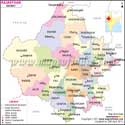
Rajasthan Map with Districts and Cities
The Rajasthan district map provides a detailed view of administrative divisions, district boundaries, major cities and important locations in Rajasthan district. The map of Rajasthan is helpful for students, tourists and those who are interested in the geographical structure of Rajasthan.
The map also indicates new administrative boundaries, division-wise districts and major urban areas. The Rajasthan map new version reflects updated administrative details and helps users understand the latest changes in the state’s divisions. Administratively, the state of Rajasthan has several divisions like Jaipur, Jodhpur, Udaipur, Kota, Ajmer, Bikaner and Bharatpur Division comprising various districts.
The arrangement of the districts in a divisional manner helps to understand the distribution of the Rajasthan districts in the state. For the administrative structure of Rajasthan, major districts or cities are clearly shown.
Rajasthan Map Showing Major Cities
The above map of the state of Rajasthan displays the significant cities in the state, which are very important in the economy, tourism, education and culture of the state.
The capital city of Rajasthan, Jaipur, is known as the Pink City and is renowned for its forts, palaces and heritage architecture. Jodhpur, popularly known as the Blue City, is famous for its Mehrangarh Fort and its culture. Udaipur is called the City of Lakes because there are so many beautiful lakes and royal palaces in the city.
Cities in Rajasthan such as Kota, Ajmer, Bikaner and Bharatpur have their own historical, educational and cultural importance. Kota is a significant education and manufacturing centre, while Ajmer is an old city that became significant within the context of religious and cultural importance. Bikaner is famous for its deserts, forts and its local cuisine. Bharatpur is known for its past and Keoladeo National Park.
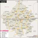
Rajasthan District Map
The Rajasthan district map shows the administrative boundaries and locations of districts across the state. It helps in identifying the position of different districts and understanding the state’s regional divisions.
Over the years, administrative changes have been made in Rajasthan, new districts have been established, and boundaries have been redrawn to facilitate governance. The updated map of the district reflects the administrative setup of Rajasthan as of now.
Some important Rajasthan districts are Jaipur, Jodhpur, Udaipur, Kota, Ajmer, Bikaner, Alwar, Barmer, Jaisalmer, Nagaur, Sikar, Bhilwara, Bharatpur, Pali, Churu and Sri Ganganagar.
A printable Rajasthan district map can be used for school projects, competitive exam preparation, travelling and geographical reference.
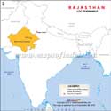
Rajasthan Location on India Map
Rajasthan is located in the northwest part of India and enjoys a strategic geographical location. The Rajasthan location on the India map helps in understanding its position, boundaries and neighbouring states. It shares the western boundary with Pakistan and is bordered by several Indian states.
The state borders the Punjab to the north, Haryana and Uttar Pradesh to the northeast, Madhya Pradesh to the southeast and Gujarat to the southwest. The latitude and longitude of Rajasthan are 23°3′ N to 30°12′ N and 69°30′ E to 78°17′ E, respectively.
The capital city, Jaipur, is well connected with other major cities of India. The distance between Jaipur and Delhi is approximately 270 km, between Jaipur and Jodhpur is approximately 340 km, between Jaipur and Udaipur is approximately 390 km and between Jaipur and Kota is 250 km.
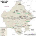
Rajasthan Rivers Map
The Rajasthan Rivers Map shows the important rivers flowing through different parts of the state. Though the climate of Rajasthan is arid, the rivers are very important in farming, watering and provision in the state.
The map of Rajasthan also helps in understanding river networks, physical features, and the relationship between rivers and settlements. The Chambal River is one of the major rivers in Rajasthan, which runs through the southeastern part of the state and irrigates the areas around Kota, Bundi and Dholpur.
Banas River is the main tributary of Chambal, passing through the central and eastern part of Rajasthan. Luni River is the largest river system located in the western part of Rajasthan. It runs near Ajmer, passing through the desert areas of Pali, Jodhpur and Barmer. The Mahi River runs through southern Rajasthan, particularly in Banswara and Dungarpur.
These rivers are significant geographical features and are depicted in the maps of the rivers of Rajasthan to understand the location and path of the rivers.
Rajasthan State Information | |
|---|---|
| Capital | Jaipur |
| Date of formation | 30/03/49 |
| Governor | Shri Haribhau Kisanrao Bagde |
| Chief Minister | Bhajan Lal Sharma |
| Tourist attractions | Mount Abu , Jaipur Palace, Hawa Mahal, Jaisalmer Fort, Ranthambore, Pushkar |
| Festivals | Teej, Gangaur festival, Bikaner festival, Marwar festival |
| Major dance and music forms | Ghoomar and Kalbeliya dances; Kathputali puppet theatre; Bhopa |
| Arts and crafts | Rajasthani miniature paintings such as Kangra, Jodhpur, Jaipur etc; Pichhvai paintings; hand-block printing; Panihari music. |
| Languages | Rajasthani, Hindi |
| Size | 342,239 km2 (132,139 sq mi) |
| Population (Census 2011) | 68548437 |
| Rivers | Luni, Banas, Kali Sindh, Chambal |
| Forests and wildlife sanctuaries | Sariska Tiger Reserve, Keoladeo Ghana NP, Ranthambore NP, Dhawa WS |
| State animal | Camel and Chinkara |
| State bird | Godawan |
| State flower | Rohinda |
| State tree | Khejri |
| Major crops | Jowar, pulses, maize, gram |
| Factoids | Jaipur's Elephant Festival has a tug-of war between humans and elephants. |
| Bikaner has a Karni Mata temple in which rats are worshipped. | |
| No. of District | 41 |
Districts in Rajasthan
| District | Headquarters | Division | Population (2011) | Area (km2) |
|---|---|---|---|---|
| Ajmer | Ajmer | Ajmer | 2584913 | 8481 |
| Alwar | Alwar | Jaipur | 3671999 | 8380 |
| Balotra | Balotra | Jodhpur | 1,115,751 | 10551 |
| Banswara | Banswara | Udaipur | 1798194 | 5037 |
| Baran | Baran | Kota | 1223921 | 6955 |
| Barmer | Barmer | Jodhpur | 2604453 | 28387 |
| Beawar | Beawar | Ajmer | 1094918 | 8481 |
| Bharatpur | Bharatpur | Bharatpur | 2549121 | 5066 |
| Bhilwara | Bhilwara | Ajmer | 2410459 | 10455 |
| Bikaner | Bikaner | Bikaner | 2367745 | 27244 |
| Bundi | Bundi | Kota | 1113725 | 5550 |
| Chittorgarh | Chittorgarh | Udaipur | 1544392 | 10856 |
| Churu | Churu | Bikaner | 2041172 | 16830 |
| Dausa | Dausa | Jaipur | 1637226 | 2950 |
| Deeg | Deeg | Bharatpur | 1072755 | 2169 |
| Didwana-Kuchaman | Didwana | Ajmer | 1625837 | 6796 |
| Dholpur | Dholpur | Bharatpur | 1207293 | 3084 |
| Dungarpur | Dungarpur | Udaipur | 1388906 | 3770 |
| Hanumangarh | Hanumangarh | Bikaner | 1779650 | 12645 |
| Jaipur | Jaipur | Jaipur | 6663971 | 14068 |
| Jaisalmer | Jaisalmer | Jodhpur | 672008 | 38401 |
| Jalor | Jalore | Jodhpur | 1830151 | 10640 |
| Jhalawar | Jhalawar | Kota | 1411327 | 6219 |
| Jhunjhunu | Jhunjhunu | Jaipur | 2139658 | 5928 |
| Jodhpur | Jodhpur | Jodhpur | 3685681 | 22850 |
| Karauli | Karauli | Bharatpur | 1458459 | 5530 |
| Khairthal-Tijara | Khairthal | Jaipur | 966821 | 2007 |
| Kota | Kota | Kota | 1950491 | 12436 |
| Kotputli-Behror | Kotputli & Behror | Jaipur | 1271426 | 2920 |
| Nagaur | Nagaur | Ajmer | 3309234 | 17718 |
| Pali | Pali | Jodhpur | 2038533 | 12387 |
| Phalodi | Phalodi | Jodhpur | 731583 | 9408 |
| Pratapgarh[1] | Pratapgarh | Udaipur | 868231 | 41173.6 |
| Rajsamand | Rajsamand | Udaipur | 1158283 | 4768 |
| Salumbar | Salumbar | Udaipur | 570775 | 2480 |
| Sawai Madhopur | Sawai Madhopur | Bharatpur | 1338114 | 10527 |
| Sikar | Sikar | Jaipur | 2677737 | 7732 |
| Sirohi | Sirohi | Jodhpur | 1037185 | 5136 |
| Sri Ganganagar | Sri Ganganagar | Bikaner | 1969520 | 7984 |
| Tonk | Tonk | Ajmer | 1421711 | 7194 |
| Udaipur | Udaipur | Udaipur | 3067549 | 17279 |
| Rajasthan | Jaipur | 68621012 | 342239 |
Maps in Other Regional Languages
PB31.01.2017
FAQs
Q1: Which states share borders with Rajasthan?
Rajasthan shares its borders with Punjab, Haryana, Uttar Pradesh, Madhya Pradesh, and Gujarat. The state also shares an international border with Pakistan.
Q2: Which is the largest district of Rajasthan by area?
Jaisalmer is among the largest districts of Rajasthan by geographical area and is located in the western part of the state.
Q3: Which are the major cities shown on the Rajasthan map?
Major cities shown on Rajasthan maps include Jaipur, Jodhpur, Udaipur, Kota, Bikaner, Ajmer, and Jaisalmer.
Q4: What are the wildlife destinations that are available to tourists?
The Ranthambore National Park, which is home to Bengal tigers and other wildlife, is frequented by nature lovers.
Q5: What is the area covered by Rajasthan as shown on the map?
Rajasthan covers a large geographical area in northwestern India and is the largest state in India by area. The Rajasthan map helps users understand its vast regional spread and boundaries.
Q6: Which rivers are visible on the Rajasthan map?
Major rivers such as the Chambal, Banas, Luni, and Mahi are among the important rivers shown on Rajasthan maps.
Q7: Which mountain range is shown on the Rajasthan map?
The Aravalli Range is an important geographical feature shown on the Rajasthan map. It runs across parts of the state and influences its landscape.
Last Updated on: June 24, 2026