Ever wondered what a pilot's compass is on the enormous, endless sea? When there is no road or landmark, what gives direction? The solution is latitude and longitude. We will take a closer look at this invisible grid, and even learn how to decipher latitude and longitude lines on our own.
What Is Latitude and Longitude?
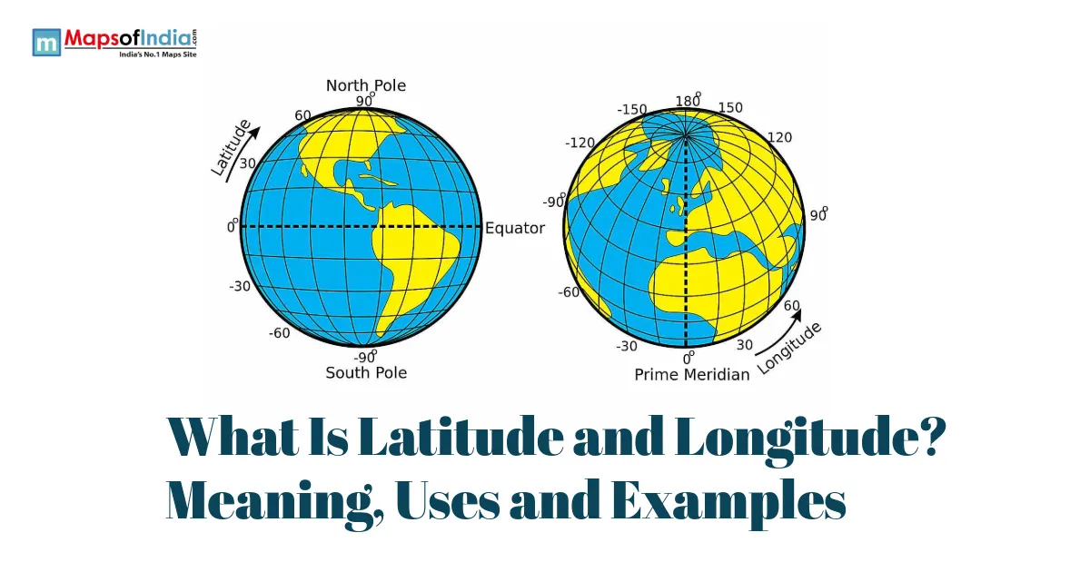
Latitude and Longitude are lines you imagine covering the Earth's grid system. This grid system allows us to pinpoint locations on Earth by a set of coordinates. Latitude lines are horizontal lines parallel to the equator, which are drawn on maps to show latitude. Latitude lines indicate the location of how far north or south a place is located; longitude lines, on the other hand, are vertical, which helps to show the location of east or west of the prime meridian.
Latitude vs. Longitude: Key Differences
Feature | Latitude | Longitude |
| Direction | Horizontal (east-west lines) | Vertical (north-south lines) |
| Measures | North-South position | East-West position |
| Reference line | Equator (0°) | Prime Meridian (0°) |
| Range | 0° to 90° (N/S) | 0° to 180° (E/W) |
| Also called | Parallels | Meridians |
How Does Latitude Work?
The Equator and Reference Point
The degrees are used to measure latitude, and the equator is the reference point for latitude. Latitude is measured from 0° at the equator to 90° North and South (the poles). Latitude lines are run east to west just like the equator. But these lines are parallel to the equator.
Major Latitude Lines
There are a number of latitude lines with which certain measurements are associated. For example, the Tropic of Cancer is a latitude that is 23.5° north, and the Tropic of Capricorn is a latitude that is 23.5° south. There are also latitude lines at 66.5N (Arctic Circle) and 66.5S (Antarctic Circle).
Latitude gets measured in degrees, then broken further into minutes and seconds for precision, much like how a clock breaks hours into minutes and seconds.
How Does Longitude Work?
The Prime Meridian and Reference Point
Degrees are also used to measure longitude, with the prime meridian as a reference. The Prime Meridian runs through Greenwich, England and is at 0°. Then, the lines of longitude go to 180°E and 180°W.
Time Zones and Longitude
The Earth rotates from west to east and does a full rotation (360°) every 24 hours, so you can say that each hour (1/24th of a day) is equal to 15° of longitude. We come up with time zones in this way. On the other side of the Earth is the International Date Line (IDL). Like the PM, the IDL is at 180°E/W. The IDL will mark the date transition at a crossing point 24 hours earlier.
How to Read Latitude and Longitude Coordinates?
For instance, the coordinate pair of a sample point would be 28.6139° N, 77.2090° E. The Latitude will always be listed first, and the longitude will always be listed second. The N (north) and E (east) notations may also be noticed. These mean the latitude and longitude readings are north of the equator and east of the prime meridian, respectively
You can convert decimal degrees to degrees, minutes, and seconds (DMS) and vice versa.
There are two ways of expressing coordinates: decimal degrees (DD) and degrees, minutes, seconds (DMS). Another representation of the above-described sample coordinate pair in DD is also possible in DMS form, 28°36’50” N, 77°12’32” E.
DD is the default of most computers and GPS software, and is easier to type, though DMS has been around for some time.
Given a point in a plane, how can you determine the coordinates?
Decoding coordinates is as easy as picking out the latitude and longitude parts. If we had the following pair of latitude and longitude:
28.6139° N, 77.2090° E.
The latitude component is 28.6139° N. The longitude is 77.2090° E.
Real-World Examples of Latitude and Longitude
Let's look at some examples of latitude and longitude coordinates:
Location | Latitude | Longitude |
| New Delhi, India | 28.6139° N | 77.2090° E |
| New York, USA | 40.7128° N | 74.0060° W |
| London, UK | 51.5074° N | 0.1278° W |
| Sydney, Australia | 33.8688° S | 151.2093° E |
| Equator (example point) | 0° | 78.4678° W |
Why Are Latitude and Longitude Important?
Latitude and longitude are coordinates mostly used in various day-to-day real-world implementations that are;
GPS & navigation: Latitude and longitude play a major part in the use of GPS and cell phone navigation apps for navigation.
Maps: Latitude and longitude are the grid system of maps, which is used on paper and digital maps.
Climate, Time Zones, and Other Geographic Features: Latitude and longitude help to determine, besides other things, the climate zone to be in and the time zones.
Military and Search and Rescue Operations: Coordinates are very important in military and search and rescue operations, and that includes targeting.
Many Everyday Applications: There are various uses of coordinates in everyday life to find out an exact delivery address or point of pick-up; for example, food delivery or ride-hailing services.
Common Misconceptions About Latitude and Longitude.
There are some of the wrong understandings about latitude and longitude:
Southern or Northern: Latitude describes the degree of a point towards either north latitude is a northern hemisphere point or south a southern hemisphere point. On the contrary, longitude describes east-west of the location, so longitude is a description of east-west movement.
Latitude vs Longitude Circles: Latitude circles are parallel with one another, whereas longitude lines are not.
In Coordinates, Latitude comes first; longitude follows second.
Conclusion
Latitude and Longitude are imaginary lines that form the Earth's grid system. The latitude lines are horizontal lines that are measured from the equator (0°) to the poles (90°N and 90°S). Lines of longitude are up and down. They are used to measure from the prime meridian (0°) to 180°E and 180°W, and they have many uses, such as navigation systems and mapping.
FAQs
1. What are latitude and longitude?
Latitude and longitude are a system of geographic coordinates used to identify the exact location of any place on the Earth's surface.
2. What is the difference between latitude and longitude?
Latitude measures a location's distance north or south of the Equator, while longitude measures its distance east or west of the Prime Meridian.
3. Why are latitude and longitude important?
Latitude and longitude help determine precise locations and are widely used in navigation, GPS, mapping, aviation, shipping, and geographic studies.
4. How are latitude and longitude measured?
Latitude and longitude are measured in degrees (°), minutes ('), and seconds (") or in decimal degrees using GPS and digital mapping systems.
5. What are the major lines of latitude and longitude?
The Equator (0° latitude) and the Prime Meridian (0° longitude) are the primary reference lines. Other important latitudes include the Tropic of Cancer, Tropic of Capricorn, Arctic Circle, and Antarctic Circle.
6. How do GPS and Google Maps use latitude and longitude?
GPS satellites and mapping applications like Google Maps use latitude and longitude coordinates to determine and display the exact location of people, places, and routes.
7. Can two places have the same latitude or longitude?
Yes. Places on the same parallel share the same latitude, while places on the same meridian share the same longitude, even though they are located in different parts of the world.