Areas Affected by Earthquake in India |
6.8 Earthquake In Bengal, Bihar And Assam, Epicentre In Myanmar
With an epicenter located more than 500 kilometres from the Indian border, an earthquake measuring 6.8 on the ritcher scale has hit Myanmar, Bihar, Patna and Kolkata. While it has been reported that the tremors lasted for 10 seconds in Kolkata, Patna experienced the strong earthquake for about three seconds. The earthquake was felt across multiple parts of the Indian state of Bihar. The massive jolt earthquake led to evacuation of office and college buildings in Kolkata. People within these constructions experienced their worst nightmare within a few seconds time.
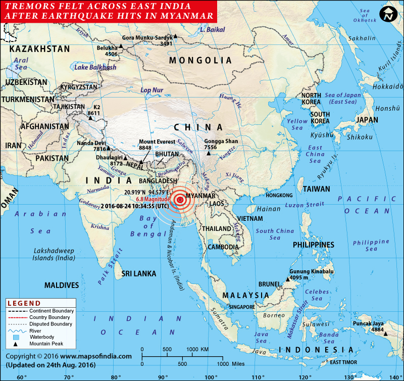
Map showing the Areas Affected by Earthquake in Eastern India
With an epicenter in Myanmar, the quake shook building situated in Myanmar’s biggest city of Yangon and a range of other cities and towns. In addition to this, even the office buildings in the Thai capital of Bangkok, located towards the east of Myanmar, shook for few seconds. Tremors of the quake were also felt in Bangladesh, which is located towards the west of Myanmar. As reported by National Centre for Seismology, a unit of Ministry of Earth Sciences, the earthquake occurred at a depth of 58 km and forced people to leave building in Patna and Guwahati too. As an aftermath of the quake, even the metro services stand suspended in Kolkata. It is surprising to know that over the past week, there has been a series of smaller earthquakes across the entire north eastern part of India. The District Magistrate of Darjeeling Anurag Shrivastava has confirmed zero casualties in Darjeeling and Siliguri, located in North Bengal. He has also ruled out any loss of life or property in both the cities.
Related Information:
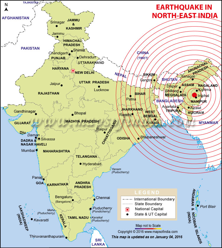
North-East India Map
Top 10 Earthquake-prone Cities in India
Map of Major Earthquakes in India
Earthquake zones of India
Indian Subcontinent Map
India Earthquake History
M6.9 Earthquake Hits Myanmar, Tremors Across Northern India
11:00 AM IST, 14 April, 2016 – The earthquake jolts were also felt in Uttar Pradesh, Chattisgarh, Odisha and Madhya Pradesh. As per the National Centre for Seismology, the earthquake occurred around 7:25 p.m. and was 74 km South East of Mawlaik in Myanmar. The quake was the second one in the day as the northeast had already witnessed a medium intensity quake measuring 4.6 hitting areas around Manipur’s capital Imphal in the morning, at around 9:26 a.m. The officials at the Regional Seismological Centre in Shillong have informed that the quake was located at a 23 degree north latitude and 94.9 degree east longitude.
7:45 PM IST, 13 April, 2016 – An earthquake with magnitude 6.9 occurred near Monywa, Myanmar at 7.25 pm on Apr 13, 2016 at a depth of 134 km. Strong tremors were reported in Guwahati and Patna, mild ones were felt in Chennai and Delhi.
6.6-magnitude earthquake hits Afghanistan: Tremors felt in North India
A powerful 6.6 magnitude earthquake, which had its epicenter in Afghanistan’s Hindukush mountain range, shook north India. The tremors of the earthquake could be felt as far as Delhi. The Delhi metro halted its operations due to the intensity of the earthquake. The earthquake has hit Afghanistan, India and Pakistan. At the moment there are no reports of any casualties or damage to property.
Map of Areas Affected by Earthquake in Northeast India
Map showing Areas Affected by Earthquake in Northeast India.
M 6.7 Earthquake Hits in Imphal, Manipur and Northeast India
Imphal Earthquake Death roll rises to 5 and nearly 100 injured
2:00 PM IST, 4 January, 2016 – With rescue work underway in Imphal, the death toll has risen to five, while 40 people have been injured, according to latest reports. The rescue operations, though hampered by snapped telecommunication links and power supplies, are being conducted to find workers believed to be buried under the rubble at a site that was under construction. This is the biggest earthquake that has been felt in Imphal.
10:00 AM IST, 4 January, 2016 – Fresh Earthquake of magnitude 3.6 felt at 9:27 am in Manipur
7:45 AM IST, 4 January, 2016 – Strong tremors rocked northeast India and adjoining Bangladesh, Myanmar and Bhutan in the wee hours on Monday, killing two people and injuring at least 30. The earthquake measuring 6.7 on the Richter Scale hit around 4.35 a.m. and had its epicentre located about 29 km west of Imphal. Apart from Manipur, jolts were also felt in Odisha and West Bengal. Sources in the disaster management team said that portions of walls and staircases have collapsed in several buildings, while roofs have caved in at places. The US Geological Survey has issued a yellow alert for deaths and damages.
The earthquake was felt in parts of Manipur, Assam, Arunachal Pradesh, Meghalaya, Nagaland, Mizoram , Tripura and West Bengal.
At least 5 dead, 100 injured in Imphal after earthquake strikes.
Read – What to do Before, During and After an Earthquake
Explore Map – Manipur Map | Imphal City Map | North-East India Map | Top 10 Earthquake-prone Cities in India | Map of Major Earthquakes in India | Earthquake zones of India
Tremors felt in Kashmir valley, Delhi, parts of north India
4:00 PM IST, 10 August, 2015 – Earthquake tremors were felt in Delhi, Kashmir valley and some other parts of India. According to the Indian Meteorological Department (IMD), an earthquake with magnitude 6.2 hit the Hindu Kush region of Afghanistan. Tremors were also experienced in Pakistan in Lahore and Islamabad. As per IMD, no loss has been reported so far.
Map showing location of Earthquake in North India, Nepal and China on 12th May, 2015.
Earthquake of magnitude 5.6 injures three in Assam; tremors felt in Bengal, Bhutan and Nepal
29 June, 2015 – A 5.6-magnitude earthquake struck Assam at around 6.40 am on Sunday morning. The epicentre of the earthquake was in Kokrajhar. According to district officials, three people sustained injuries when an old wall collapsed near the Kokrajhar railway station. A lion sculpture in an ancient temple in Chirang district was damaged after it fell off its stand during the earthquake. The tremors were felt in West Bengal, Meghalaya, Bhutan, Bangladesh and Nepal.
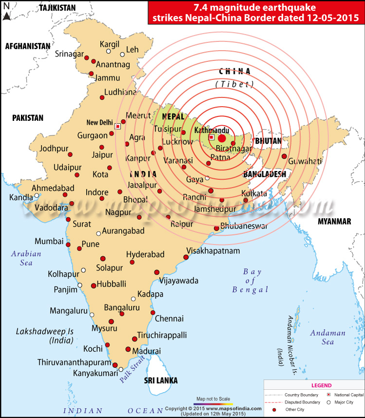
M7.4 Earthquake Hits Nepal, Tremors Across Northern India on 12 May, 2015
Earthquake Affected Places In India
Tremors were felt across Bihar, West Bengal, Uttar Pradesh, Madhya Pradesh, Gujarat, Assam, Jharkhand, and some parts of Odisha.
– 17 persons killed in earthquake in India, of them 16 in Bihar, 1 in UP; 39 others injured: Home Ministry
Nepal hit by another earthquake, tremors felt in India
Nepal was hit by another earthquake measuring 6.3 on the Richter scale. The second earthquake, which came after a gap of approximately 30 minutes, had its epicentre 33 km (21mi) from Ramechhap and 83km (52mi) east of the capital city of Kathmandu. Tremors of the earthquake could be felt as far away as North India in cities like Srinagar, Amritsar, Lucknow and Jaipur. In Delhi, buildings swayed for more than a minute, however, there were no reports of damages but Delhi Metro services were halted as a precaution.
Nepal struck by earthquake again
12:40 PM IST – A major earthquake measuring 7.4 on the Richter scale hit Nepal today. According to the US Geological Survey, the earthquake, which was 19 km deep, hit around 68 km west of Namche Bazaar. The tremors of the earthquake were also felt in India and people could be seen rushing out of their homes and cities in Patna, Gurgaon and Delhi. The earthquake has just come after the devastating 7.8 magnitude earthquake that hit Nepal on April 25, 2015.
M7.4 Earthquake Location: 27.843N 86.153E
Distances:
22 km (14 mi) SE of Zham, China
66 km (41 mi) ENE of Banepa, Nepal
69 km (43 mi) ENE of Panaoti, Nepal
83 km (51 mi) E of Kathmandu, Nepal
84 km (52 mi) ENE of Patan, Nepal
Indian Embassy Helpline numbers in Nepal: (+977) 9851107021; (+977) 9851135141
25th April, 2015 Nepal and North India Earthquake Highlights
Earthquake Map | Emergency Number | Affected Areas | Recent Earthquakes | Day 4 | Day 3 | Day 2 | Day 1
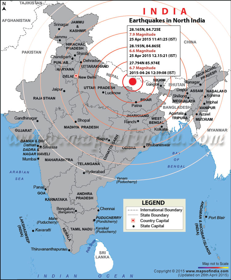
Map showing the location of Earthquake on 25th and 26th April, 2015 in North India and Nepal.
Areas Affected by Earthquake in India on 25th April, 2015
Bihar, Uttar Pradesh, West Bengal, Delhi/NCR, Assam, Uttarakhand, Andhra Pradesh, Odisha, Gujarat, Sikkim, Karnataka, Kochi, Kerala
Bihar Affected Areas – Patna district, Samastipur, Bhagalpur districts, Bhita, Supual, Darbhanga, Muzaffarpur, Gopalganj.
Uttar Pradesh Affected Areas – Kanpur, lucknow, allahabad, Agra, Varanashi, Jhansi, Sonebhadra, Gorakhpur.
West Bengal Affected Areas – Kolkata, Lake Town, Salt Lake, Dalhousie, Darjeeling/Siliguri, Park street area, Telipara, Purulia, Bankura, Burdwan, East Midnapore and Nadia district.
Other Cities – New Delhi, Noida, Chandigarh, Jaipur, Barmer, Dumka, Pakur, Sahibganj, rishikesh, Ahmedabad, Ranchi, Jamshedpur, Bhubaneswar, Visakhapatnam, Srikakulam, East Godavari districts, Kochi, Nagpur and Jabalpur, Jafar Nagar, Jaripatka, Bhopal, Gwalior, Mandla, Hoshangabad, Sidhi, Indore, Chhindwara and Shahdol among other districts, Met Department officials said here.
Areas Affected by Earthquake in Nepal
- Kathmandu City (worst hit areas- Jhochhen, Thamel, Basantpur, Nardevi)
- Kathmandu Valley (worst hit areas- Rasuwa, Sindhupalchowk, Gorkha, Dolakha, Dhading)
- Bhaktapur, Lalitpur, Lamjung, Kirtipur, Kodari, Nagarkot, Panaoti, Banepa
Live Updates on Earthquake
#earthquake Tweets
//
Related Information:
Top 10 Earthquake-prone Cities in India