


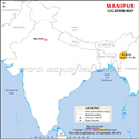

As it is a sensitive border area, Tourists who want to travel to Manipur require a Restricted Area Permit.
Manipur spreads across a total area of 22,327 km2 (8,621 sq mi). The state ranks 23rd in terms of area amongst the states and union territories of the country. Its population recorded 2,855,794 (as per the 2011 census). The population density of the state was 130/km2 (330/sq mi) (as per the 2011 census). Manipur is in the 23rd rank regarding population in the country.
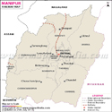
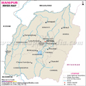
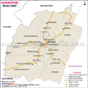
The meaning of Manipur is the land of jewels. It is replete with natural splendor and grandeur. It has 16 districts: Bishnupur, Chandel, Churachandpur, Imphal East, Imphal West, Senapati, Tamenglong, Thoubal, Ukhrul, Kangpokpi, Tengnoupal, Pherzawl, Noney, Kamjong, Jiribam, Kakching.
The eye-catching gorgeous rivers of the tiny state Manipur play a significant role in its topography. It is a land of several rivers, and the breathtaking streams of the river adorn Manipur even more. Some of the prominent rivers of the state are- Barak River, Imphal River, and many more.
Economy
The economy of Manipur mainly depends on agriculture, industries, tourism sector. The climate and soil conditions of the state are ideal for horticultural crops.
The state is also known for the growth of exotic medicinal and aromatic plants. Some of the horticulture products of Manipur are famous in terms of generating revenue- orange, lemon papaya, passion fruit, peach, plum, and so on. Cashew and walnut are also grown in the state.
The industrial development in Manipur is in progress. However, the state is striving towards industrialization, with the setting up of many large and small-scale industrial units. The key industries of Manipur are pharmaceuticals, steel re-rolling, plywood, bamboo chipping, cement, vanaspati, and electronics, and the service sector comprises Real estate, Consultancies, Travel, and Tourism, Hotel Industry, and Insurance.
Transportation
Roads are the lifeline and regarded as the arteries and veins for the people of Manipur. Roads and highways are the main infrastructures for the economic development of the state. Therefore the state government also gives lots of emphasis on the construction of better roads.
Some major highways pass through the state are- NH 39 (renamed as NH-2 ), NH 53, NH 137A, and many more.
The Railway network is not well-developed in the state. Currently, Manipur has two railway stations, while the Imphal railway station is under construction. The 111 km long, Jiribam- Imphal railway line is to be completed by March 2022.
Imphal Airport, also known as Bir Tikendrajit Airport, is a domestic upgraded new international airport situated in Imphal.
Manipur State Information | |
|---|---|
| Capital | Imphal |
| Date of formation | 21. Jan. 1972 |
| Governor | Shri Ajay Kumar Bhalla |
| Chief Minister | Nongthombam Biren Singh |
| Tourist attractions | Loktak Lake. Sendra Island |
| Festivals | Heikru Hitongba Boat Races, Baruni |
| Major dance and music forms | Ras Lila, Lai Haroba, Nongdai Jagoi |
| Arts and crafts | Bamboo baskets, fish traps, mats, umbrellas, musical instruments etc. |
| Languages | Manipuri, Thado, Tankhul |
| Size | 22,327 sq. km |
| Population (Census 2011) | 2855794 |
| Rivers | Imphal River, Barak, Manipur River |
| Forests and wildlife sanctuaries | Keibul Lamjao NP, Khonghampat Orchidarium |
| State animal | Sangai |
| State bird | Nongyeen |
| State flower | Siroi lily |
| State tree | Uningthou |
| Major crops | Paddy, wheat, maize, pulses |
| Factoids | The Pung is the Manipuri version of the Mridanga, an ancient drum and is played during the Ras Lila. |
| Imphal has an all-women's market or Ima Keithel. | |
| No. of District | 16 |
Last Updated on : June 24, 2026
| General Maps of Manipur |
| Buy this Map |