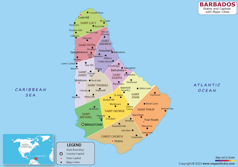
Barbados is a Caribbean island country situated in the eastern Caribbean Basin. It is the most easterly island in the Caribbean and is a popular destination for tourists due to its warm climate, beautiful beaches, and rich culture. The capital city is Bridgetown, located on the southwest coast of the island.
History
Barbados was initially inhabited by the indigenous Amerindian tribes, including the Arawaks and the Caribs. However, the island was later colonized by the English in 1627 and became a center of sugar production. The island's economy was built on the backs of enslaved Africans who were brought to the island to work on the sugar plantations. The abolition of slavery in 1834 marked a major turning point in the island's history, leading to the rise of the middle class and greater political and social equality.
Barbados gained independence from Britain in 1966 and became a parliamentary democracy. Today, the island's economy is driven by tourism and the financial services sector.
Culture
Barbadian culture is a blend of African, European, and Caribbean influences. Music is an important part of the culture, with calypso and soca being popular genres. The island is also famous for its crop over the festival, which takes place in July and August and features music, dancing, and other festivities.
Language
The official language of Barbados is English, and the accent and dialect spoken on the island are known as Bajan. Bajan English has its roots in West African and English dialects and has evolved over time to include influences from other Caribbean languages.
Geography
Barbados is located in the eastern Caribbean Sea, east of Saint Vincent and the Grenadines and northeast of Trinidad and Tobago. It is a relatively small island, measuring just 21 miles long and 14 miles wide. The island is mostly flat, with the highest point being Mount Hillaby at 1,100 feet above sea level.
The island is also known for its beautiful beaches and clear waters, making it a popular destination for tourists. In terms of wildlife, the island is home to a variety of species, including monkeys, sea turtles, and a wide range of bird species.
| Official Name | Barbados |
| Capital | Bridgetown |
| Population | 281635 |
| Area | 439 km2 |
| Currency | Barbadian Dollar |
| Religion | Christianity |
| Language | English |
| Major Cities | Holetown, Oistins, Bathsheba |
FAQs
Q1: What is the currency used in Barbados?
The official currency of Barbados is the Barbadian dollar (BBD), which is pegged to the US dollar at a fixed rate.
Q2: What are some popular attractions in Barbados?
Barbados has many popular attractions, including beaches, historic sites such as St. Nicholas Abbey and the George Washington House, natural attractions like Harrison's Cave and the Animal Flower Cave, and cultural events like the crop over the festival.
Q3: Is Barbados a safe destination for tourists?
Barbados is generally considered a safe destination for tourists, with a low crime rate. However, as with any travel destination, it is important to take basic safety precautions, such as being aware of your surroundings and avoiding isolated areas at night.
Q4: What is the weather like in Barbados?
The average temperature is around 80°F (27°C), and the rainy season runs from June to November.
Last Updated on: March 03, 2023
