
Maps have been important to people for hundreds of years, as they allow us to understand, and orient ourselves in our environment. Indeed, the art of mapping has come a long way from the first map drawn on the parchment by ancient cartographers down to our latest gadgets maps for mobile phones. To begin with, in this article, we will look at the various categories of maps available and how printable maps of any size can be so beneficial.
Types of Maps:
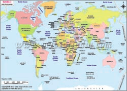
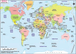
Political maps are among the most basic types of maps that are usually used. They depict the boundaries of government in countries, states, and counties as well as the places of significant cities. These maps are very useful when it comes to understanding political regions and are applied in schools when studying geography. Political maps also shade areas of controversy and give information concerning political systems, relations, and conflicts.
Contour maps depict features of physical geography including plains, crests, slopes, and valleys. They apply various colors for elevation purposes and help one to tell the general contour of a given area. Sports and activities lovers mainly use physical maps in exploring natural terrains. Speaking of their application, these maps may are also useful in environmental studies, pointing to the locations of natural resources and habitats.
Topographic maps give physical features of the surface of the ground in a particular region. They employ contour lines, to depict changes in elevation and contain some elements such as forest, water sources, and structures. Such maps are as useful for purposes like hiking, planning, and development of urban spaces, geological research, etc. They are also applied to military tactics, for instance for mapping the most suitable trails to use in specific terrains.
Thematic maps are maps that are designed based on some themes of interest e.g. population density, climate, and types of economic activity among others. They are used to explore and summarize data and patterns, thus serving the interests of the researcher, policymaker, and teacher. For instance, a thematic map may indicate the pattern of rainfall within an area and is useful in determining the most suitable farmland or water reserves to develop. Such maps can also depict social concerns like health or crime rates for which they open useful conclusions in the formation of policies.
Road maps are for reference and they provide information about the locations of main and minor roads, highways besides other features. It gives the driver and any other traveler be ability to plot routes and locate other particular places. Despite the growth of GPS navigation systems, printable road maps continue to provide additional backup navigation tools. As well as including the location of service areas, garages, and points of interest, road maps may also provide information about available services.
Geological theory maps are used to show types of rocks and geographical structures in an area. The users of these are the geologists who use them to analyze the structure of the Earth and also engineers who use them for structure construction purposes. These maps are often used to contain facts about fault lines, minerals, and types of soil. Geological maps are useful in the determination of areas with a high risk of natural disasters. For example, areas that are likely to be affected by an earthquake or a landslide.
Climate maps give information about climate aspects such as temperature, rainfall, and weather. These are helpful to meteorologists, environmental scientists, and anybody who would like to learn more about climate fluctuations. These tools of climate maps include historical and forecast climate information that is useful in studying climate change. They are also used in agriculture to define which type of crops grow in which part of the world.
Geographical information from historical maps refers to geographical data that describe a certain way or time. They are of benefit to historians, archaeologists, and any other researcher interested in past events and the transformation of physical features. These maps can give clues on how different territories have developed over time: political divisions, people migration, or use of territory. In historical maps, genealogists use these maps to determine the history of families and their original homesteads.
Significance of Printable Maps In Different Sizes:
There are quite a number of printable maps available each of which is of different size and for different uses and with different characteristics. Here are some ways in which maps of different sizes can be useful:
Large-scale maps, such as those with a scale of 1:10,000 or larger, give detailed information about small areas. They are suitable for use in city planning, and in estate agencies to determine the boundaries of the land and general navigation. For instance; an aerial view of a city may depict specific streets, structures, as well as stations, which are beneficial in city development planning for local authorities and especially for immediate response to disasters. Real estate is also a major area where large-scale maps are applied to denote property and land characterization.
Medium-scale maps, typically with scales between 1:50 000 and 1: 100 000, ratio of balance detail and spatial coverage. Some of the common applications related to them include regional planning uses and purposes such as hiking and bicycle riding and use in education among others. These maps can cover large areas of an entire county or a region but at the same time, the detail displayed is sufficient to be used in real situations. Medium-scale maps are also applied for environmental purposes, revealing the geographical location of environmental systems and resource.
Small-scale maps, such as those with a scale of 1:250,000 or smaller, cover large areas of pixelation, and less detail. They are especially helpful in providing the overall backgrounds, and national or even continental maps. It is usually found on a small scale together with its uses where it is used by travelers and researchers to gain an understanding of large expanses of land and in planning long routes. Small-scale maps are also employed in global studies to help compare small regions and consequently analyze global trends.
Custom-sized maps can be made for virtually any requirement whether may be in a classroom, business presentation, or project. The fact that maps can be printed at any size is sure to be useful to help the user home in on the level of detail required. For example, an enlarged map of a particular locality for a neighborhood festival can also include the local attractions. Special maps can be developed for marketing purposes or just for some investigation.
Portable Maps are a case for small maps that can be folded. These maps are helpful for travelers and other people who spend a lot of time outdoors. An advantage of pocket maps is that they can be taken around, and can be easily consulted during hiking, biking, or when visiting a new place. It is evident that the use of paper maps is acceptable even in the current world where most of the maps are found online. Even in emergency situations the maps can be easily carried around and easily referred to without having to use other gadgets.
Educational printable maps of various sizes are very useful in the educational field. Classroom maps are often used to teach geography, history, and social studies in large teaching walls. Students can manipulate these maps and this makes their learning experience more appealing. So, it is possible to use very small maps in textbooks and handouts, as illustrations for particular lessons. They can also be applied during gamification, for example, in map quizzes and projects.
Maps can be ornamental as there is the presence of a different kind of map known as Decorative Maps. Some of these types of maps that can be printed include navigational maps, physical maps, illusion maps, and architectural maps, and thus one can use these maps as drawings to enhance the interior design of homes, and offices among other places. Especially if people decide to hang up historical maps, they will add a bit of both history and elegance to the room. Maps can be printed in any size to fit a particular frame or wall space, which makes them functional as well as beautiful home decorations. The elaborate maps can also be customized, for example, locating regions with which one has visited or possibly the background of their ancestry.
There is also a prevalent use for the Business and Marketing Maps. Generally, businesses utilize maps for numerous purposes such as market analysis, logistics, and customer outreach. Besides, printable maps are flexible in nature since they allow one to add features like; sales territory, delivery routes, and demographics among others. They are useful in that they assist organizations in making the most appropriate choices and running their procedures in the best way possible. Concurrently, it is also important to note that marketing maps may also be applied in presentations of reports as they offer a takeaway of data and strategy.
FAQs
Q1: What are the benefits of using printable world maps?
Benefits include easy to use, markable, portable, customizable, and cost-effective.
Q2: What types of printable world maps are available?
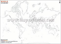
Available types include political maps, physical maps, outline maps, labeled maps, and blank maps.
Q3: How can I customize printable world maps?
Customization is possible by adding markers or labels, modifying scale or projection, and selecting specific regions or features.
Q4: What is the best paper size for printing world maps?
Recommended paper size for a map is A3, A2, or letter size (8.5 x 11 inches), depending on the desired scale and detail.
Q5: Are printable world maps suitable for educational purposes?
Printable world maps are valuable teaching tools for geography, history, and cultural studies.
Last Updated on : June 22, 2026
