






The moving Earth
The Earth's surface- geologically called the Lithosphere- is made up of large plates, in constant motion, travelling a few centimeters every year. The hot magma or molten rock inside the core of the earth causes convection currents which move the plates in different directions.
The continents, countries within those continents, and the ocean basins rest on the Lithosphere or the top crust of the earth and so are part of the moving tectonic plates. The landmasses and the ocean floors which are part of the plates are constantly moving, spreading from the center, and striking at the edges. In a way there is intense geological activity which is constantly changing the surface features of the Earth. We can't see these changes but over time - sometimes millions of years - they can be enormous and are reflected on the world map.
The different Tectonic plates
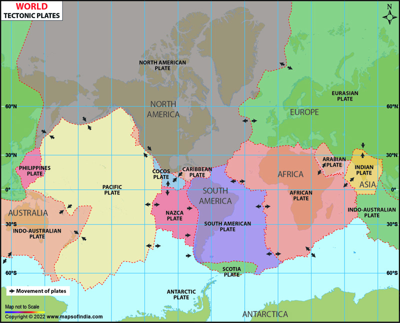
This map displays tectonic plates, all shaded differently, and the continents and oceans which constitute those tectonic plates. The direction of the movement of the plates is also marked on the map.
The fifteen tectonic plates are: Indo- Australian plate, Philipino plate, Pacific plate, Juan De Fuca plate, North American plate, Cocos plate, Nazca plate, Caribbean plate, Antarctic Plate, Scotia plate, Eurasian plate, Arabian plate, African plate, South American plate, and Indian plate.
The edges of these plates, where they move against each other are sites of intense geological activity such as earth quakes, volcanoes and mountain building. In fact, Himalayas, the highest mountain ranges in the world were built this way. Fifty- five million years ago, The Indian plate, considered part of the Indo Australian plate collided with the Eurasian plate and pushed up the mountains. As the Indian Plate and the Indo Australian plate are still moving north, these mountains are still growing. As a result of the movement of the plates, this region is earthquake prone too.
The North American and Eurasian plates are large plates, though the small size of the Juan de Fuca plate, despite its small size, is associated with significant volcanic activity and earthquakes.
The area where the Pacific and North American plates meet is the site of intense earthquakes, and the 'Ring of Fire' around the perimeter of the Pacific Ocean is the site for a string of active Volcanoes. As the Pacific plate moves, it rubs against the surrounding plates and this rubbing or movement causes the molten magma to erupt all around the plate's outer edges.
FAQs
Q1: What does a world tectonic plates map show?
A world tectonic plates map shows the major tectonic plates of the Earth, their boundaries, and the direction in which they are moving.
Q2: What are tectonic plates?
Tectonic plates are large, rigid pieces of the Earth's lithosphere that move slowly over the semi-molten mantle beneath them.
Q3: Why do tectonic plates move?
Tectonic plates move because of convection currents generated by heat from the Earth's interior, causing the plates to shift over time.
Q4: What happens when tectonic plates meet?
When tectonic plates collide, separate, or slide past one another, they can cause earthquakes, volcanic eruptions, and the formation of mountain ranges.
Q5: Why is the Ring of Fire important?
The Ring of Fire is a region surrounding the Pacific Ocean where many tectonic plates meet, making it one of the world's most active zones for earthquakes and volcanoes.
Q6: Which tectonic plates formed the Himalayas?
The Himalayas were formed by the collision of the Indian Plate and the Eurasian Plate, a process that continues today.
Q7: Why is a world tectonic plates map useful?
A world tectonic plates map helps students, researchers, and geography enthusiasts understand plate boundaries, geological activity, and the movement of the Earth's crust.
Last Updated on : July 03, 2026


