

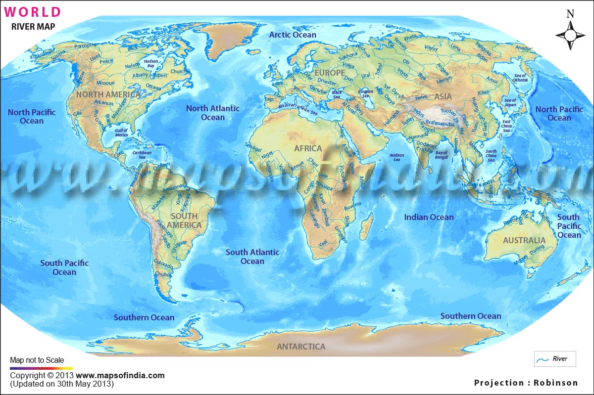





Offering an enchanting glimpse in the network of waterways that pass through the globe, river maps turn out to be inherent representations of river systems, including graphical indicators of their course, characteristics, and the adjoining environments. Serving as sources of freshwater, they are essential for human societies and freshwater ecosystems and play a vital role in sustaining terrestrial life.
All the river-based maps differ in terms of their purposes and are often categorized on the basis of the information that they cater to the people. Such maps can be depicted in the form of cartographic maps, topographic maps, bathymetric maps, hydrologic maps, Geographic Information Systems (GIS) maps, and online interactive maps.These maps can be employed for a variety of purposes and provide information about the river names and their tributaries; their course, direction, length, and width; surrounding terrain and land use; as well as adjoining conservation areas and protected zones. When used alongside a world map, river maps offer a better understanding of the distribution of major waterways across continents.
Economic Significance of Rivers:
Economy is largely driven through trade and exchange of commodities. Rivers form an integral medium for the transport of these commodities, thereby facilitating trade and commerce. They also provide hydropower, which is used to generate electricity, and this form of energy is renewable in nature. The pristine beauty of hydrological features also draws in visitors, which makes these places ideal tourist spots. The influx of tourists aids in revenue generation and thus garners support for the local traditions and the indigenous people.
Cultural Significance of Rivers:
From earlier times dating back to the ancient period, civilizations always began close to a water source as it not only supplemented their subsistence needs but also provided a means of transportation that could be easily availed. In many regions of the world, these rivers hold a spiritual essence and are often revered in many cultures, being associated with life, renewal, and connection to the divine. The Ganges River in India is not only supportive of fishing, aquaculture, and tourism but also is revered and associated with cultural and spiritual emotions. These also aid in strengthening the sense of community identity as people are drawn together through the sense of belongingness attached to the waterbody. Furthermore, the areas surrounding the rivers serve as sites of recreation as people delve intp enjoying the pristine beauty of nature and indulge in leisure activities.
Major Rivers across Continents:
The Asian continent is a patchwork of various topographies and identities that are reflected through its various physical features as well as distinguishing forms of life. The continent is home to a large number of water bodies that supplement life and are often accompanied with feelings of spirituality and reverence. The major rivers that find a home here include the Yangtze River and Yellow River in China, the Mekong River (passing through China, Laos, Thailand, Cambodia, and Vietnam), the Ganges River, and the Brahmaputra which pass through India and Bangladesh. Out of these, the Yangtze River turns out to be the longest river in Asia, with a length of approximately 6,300 km.
Following this, Africa comes into the picture, occupying within itself some of the prominent rivers of the world. Being home to rainforests and a wide variety of wildlife, rivers become an inevitable support system for these regions. Key rivers that are situated within the continent are the Nile River, Congo River, Niger River, and Zambezi River. An important feature of these hydrological bodies is that they are not limited to the boundaries of one country but rather keep flowing through various adjoining countries. Within this spectrum, the Nile River is widely regarded as one of the longest rivers in the world, although some studies identify the Amazon River as the longest depending on the measurement methodology. The Nile Basin extends across 11 countries. Lying in the close proximity of exuberant spots such as the Pyramids of Giza, the Temple of Karnak, the Valley of the Kings, and the Nile River Cruise, the river can be provided with the metaphor of a magnet for adventure enthusiasts.
In terms of Europe, the rivers are not only recognized for their economic and historical basis but are rather pivotal for their natural beauty and their significance in the arena of tourism. From the high and mighty Danube to the serene Loire, they have played a major part in shaping the culture and identity of the civilizations and landscapes that lay in close proximity. The Volga River, Danube River, Rhine River, and Elbe River have risen up to become prime locations to be dotted on the European maps. The Volga River is the longest river within the continent, and the Danube River lies in the second spot with its length flowing through or bordering a total of 10 countries, making it the world's most international river.
The rivers of North America are like arteries that provide much needed water resources to supplement the ecosystems, economies, and cultures across the landscape. Originating from Lake Itasca in Minnesota, the Mississippi River has withstood the test of time, remained the primary route for explorers moving towards the west, and has been crucial for transportation, trade, and cultural development of the various constituent regions of the United States. It passes through a total of ten states, which include Minnesota, Wisconsin, Iowa, Illinois, Kentucky, Tennessee, Missouri, Arkansas, Mississippi, and Louisiana. The Yukon River served as an important transportation route during the Klondike Gold Rush, which runs through Alaska and Canada. Apart from this, the vast Colorado River which lines the Grand Canyon, the tranquil St. Lawrence River, and the pristine Rio Grande River, all turn out to be essential for agricultural production, as well as for mitigating infrastructural developments.
The South American continent is home to the Amazon rainforests, which are characterized by the Amazon River, the longest river within its boundaries and one that serves as a lifeline for various species of flora and fauna. To name a few, the Parana, Sao Francisco, and Orinoco rivers form vital waterways that connect distant areas of the extensive landscape. These are vital for localized agriculture, transportation, and industry, as well as play key roles in the cultural and spiritual arenas of the indigenous communities. They also demonstrate myriad ways of bringing together various aspects of the economy and blending them with the resources abundant in nature.
In close contradiction to this, Australia and Antarctica are marked by the presence of many intermittent and seasonal rivers, while Antarctica is characterized by short seasonal meltwater streams that flow during the summer months. As far as Australia is concerned, the major rivers present within the island continent include the Murray River, Darling River, Cooper Creek, Swan River, Hawkesbury River, and Brisbane River. Among these, the Murray River is the longest, stretching approximately 2,508 km. They are adapted to support unique forms of wildlife such as platypus, echidnas, and fish species.
Additionally, the rivers in Antarctica often remain frozen due to the continent’s extreme climatic conditions. The longest river in the vicinity is the Onyx River, which is approximately 32 km long and flows only during the Antarctic summer. Apart from this, other water bodies that mark their existence include the Alph River, Scott River, and Taylor River. These rivers are supportive of the unique ecosystems, which include microorganisms, algae, and invertebrates. They are composed of distinct chemical properties and owe this to the surrounding geological features and the lack of vegetation.
However, these rivers should not be attributed as only being limited to the role of facilitating economic prosperity. Rather than this, the understanding should be developed from a wider vantage point that brings out the intricacies of them serving as the bridge between human needs and natural resources. Yet these do not always remain prosperous and often encounter threats to their channels. Adversities such as pollution, climate change, and overexploitation pose a threat to the existence of water resources. This in turn calls for a need for sustainable water management and adoption of conservation efforts in order to preserve the resources in their pristine state.
Importance of River Maps:
By aiding human life by providing a visual representation of the rivers and their course, these maps are essential for everyday activities linked to a variety of purposes, such as navigation. Some of the key areas in which such maps are utilized include the field of navigation, making informed decisions regarding urban planning, supporting scientific research, carrying out community outreach initiatives, environmental monitoring, flood risk management, and infrastructure development.
FAQs
Q1: What is a river map?
A river map is a map that shows the location, course, tributaries, and surrounding features of rivers. It helps users understand river systems and their geographical distribution.
Q2: How does a world map help in studying rivers?
A world map provides a global view of the major river systems across continents, making it easier to compare their locations, lengths, and the countries they flow through.
Q3: Which is the longest river in the world?
The title of the world's longest river is debated between the Nile River and the Amazon River, depending on the measurement method used. Both are among the longest and most significant river systems on Earth.
Q4: What information can be found on a river map?
A river map typically displays river names, tributaries, flow direction, river length, surrounding terrain, nearby settlements, and other important geographical features.
Q5: Why are rivers important for human societies?
Rivers provide freshwater, support agriculture, generate hydropower, facilitate transportation, sustain ecosystems, and contribute to trade, tourism, and cultural heritage.
Q6: What are the major rivers shown on a world map?
A world map commonly highlights major rivers such as the Nile, Amazon, Yangtze, Mississippi, Danube, Volga, Congo, Mekong, Ganges, and Murray, among others.
Q7: Why are river maps important?
River maps are valuable for navigation, education, environmental conservation, flood management, urban planning, scientific research, and understanding the relationship between rivers and human settlements.
Last Updated on : July 06, 2026


