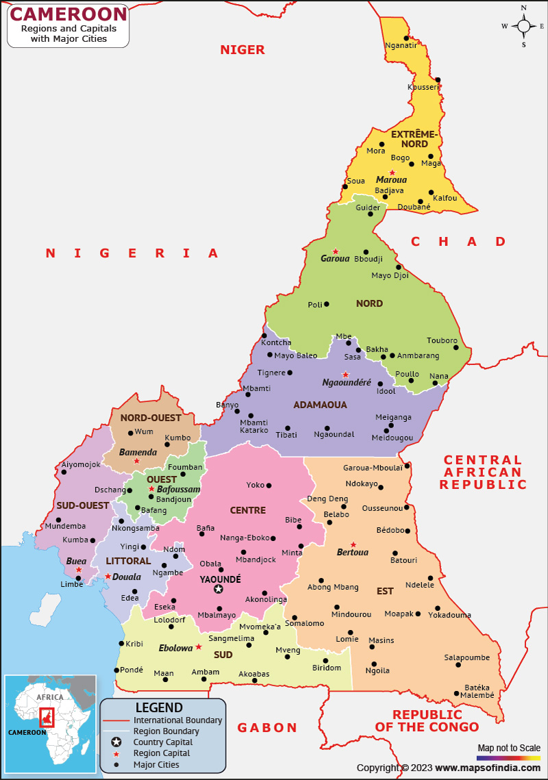
West-central Africa's Cameroon is officially known as the Republic of Cameroon. Cameroon is the world's 53rd largest country by area, measuring 475,440 km2. The country of Cameroon is well known for its indigenous music genres, particularly Makossa, Njang, and Bikutsi. Its multiethnic population is one of the most urbanized in western Africa.
In the country's south-central region is Yaoundé, which serves as the capital. Douala, the largest city in the nation and the center of commerce and industry, is also its main port.
In the south-central region of the nation, Yaoundé serves as the capital. The largest city in the nation is Douala, which also serves as the main port and the center of commerce and industry.
History:
The region that is now Cameroon has seen human habitation since sometime in the Middle Paleolithic, most likely no later than 130,000 years ago. It is located at the intersection of West Africa and Central Africa.
Following the start of World War I in 1914, the French and British engaged in the Kamerun campaign, invading French Equatorial Africa from that country and Cameroon from Nigeria. In 1916, the nation's final German fort was captured. France took the greater geographical portion, returned Neukamerun to nearby French colonies, and ruled the remaining territory as Cameroun from Yaoundé. The British colony of Cameroons, which had a population that was roughly equal to that of Nigeria and bordered that country from the sea to Lake Chad, was governed by Lagos.
Culture:
Each of the nation's major ethnic groups has created its own culture. The northern Cameroonians' flute music contrasts with the ferocious rhythms played on the drums by the people of the southern forest region. The ceremony, festival, social gathering, and storytelling all include music and dance in Cameroon. From pure entertainment to religious piety, the dances serve a variety of purposes. Oral transmission has long been the norm for music.
Language:
The official languages of Cameroon are French and English, a legacy of the country's colonial past. At least 250 languages are spoken in Cameroon. On the other hand, some sources claim there are about 600 languages. Although the country strives for bilingualism, very few Cameroonians are fluent in both French and English and even fewer are.
Geography:
From the Gulf of Guinea to the edge of a plateau, the coastal plain of Cameroon stretches 20 to 80 kilometers inland. In West Africa, Cameroon is a country with a mix of desert plains in the north, mountains in the center, and tropical rainforests in the south. Mountains, including the volcanic Cameroon Mountain, which at 13,451 feet is the highest point in West Africa, line its western border with Nigeria.
| Official name | Republic of Cameroon |
| Capital | Yaoundé |
| Population | 2.72 crores |
| Area | 475,442 km² |
| Currency | Central African CFA franc |
| Religion | Christianity |
| Language | French and English |
| Major Cities | Douala, Yaoundé, Garoua |
FAQs
Q1.What is the official language of Cameroon?
The official languages of Cameroon are French and English
Q2.What is the capital of Cameroon?
Yaoundé is the capital of Cameroon.
Q3.What is the currency of Cameroon?
Central African CFA franc is the currency of Cameroon.
Q4.What is the climate of Cameroon?
Humidity and equatorial temperatures are typical of the southern region of the nation. With temperatures between 25 and 30 degrees Celsius, northern Cameroon is dry and semi-arid.
Last Updated on: April 13, 2023
