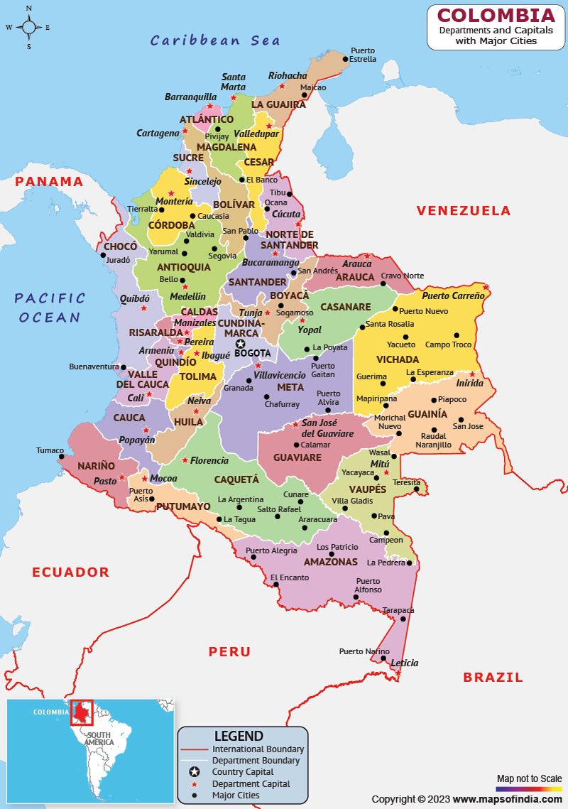
The Republic of Colombia or Colombia is a South American country with islands in North America (on the Caribbean coast of Nicaragua) and the Pacific Ocean. The country is bordered by the Caribbean Sea to the north, Brazil to the southeast, Venezuela to the east and northeast, Peru and Ecuador to the south and southwest, Panama to the northwest, and the Pacific Ocean to the west.
History:
People of different groups and cultures lived in Colombia since 12,000 BCE. The Spanish first landed in La Guajira in 1499 and in the mid-16th century explored and colonized much of what is now Colombia, establishing the new Kingdom of Granada and Santa Fe de Bogotá was its capital.
Independence from the Spanish Empire was achieved in 1819, and present-day Colombia emerged as the United Province of New Granada. This new state experienced federalism as the Confederation of the Grenadines (1858) and then the United States of Colombia (1863) before becoming a republic (now the Republic of Colombia) in 1886.
Culture:
Colombia has been influenced by a wide range of cultural influences as it lies at the crossroads of Latin America and the broader American continents. In the modern Colombian culture, Native American, Spanish, and other European, African, American, Caribbean, Middle Eastern, and other Latin American cultural influences are reflected. Urban migration, industrialization, globalization and other political, social and economic changes have also affected me.
Colombian art is more than 3000 years old. Colombian artists have used different styles and mediums to depict the country's political and cultural changes. Colombian music combines European-influenced guitar and vocal structures with large gata flutes and indigenous percussion instruments, but the percussion structures and dance forms come from Africa.
Language:
Spanish, also called Castilian is spoken by more than 99.2% of the population of Colombia. Two Creole languages, 65 Amerindian languages, the Romani language and Colombian Sign language are also spoken in the country. English is recognized as an official language in the archipelago of San Andres, Providencia and Santa Catalina. A total of 101 languages including Spanish are listed in the Ethnologue database for Colombia.
Geography:
Colombia is distinguished by its six main natural regions. These regions have their own unique characteristics. The regions include the Andean region shared with Venezuela and Ecuador, the Caribbean coastal area shared with Panama and Venezuela, the Pacific coastal zone shared with Ecuador and Panama, the Amazon rainforest region shared with Brazil, Venezuela, Ecuador, and Peru, the LIanos (plains) shared with Venezuela and the Island region consisting of islands in both the Pacific and Atlantic Ocean.
| Official name | Republic of Colombia |
| Capital | Bogota |
| Population | 5.15 crores |
| Area | 1,141,748 sq kilometres |
| Currency | Colombian Peso |
| Religion | Catholicism |
| Language | Spanish or Castilian |
| Major cities | Barranquilla, Bogota, Cali, Cartagena and Madellin |
FAQs
Q.1. When did Colombia get Independence?
Ans. Colombia become independent on July 20, 1810.
Q.2. What is the climatic condition in Colombia?
Ans. Colombia has a tropical climate presenting variations within six natural regions, which depend on the temperature, altitude, humidity, rainfall, and winds.
Q.3. What is the Government and political structure of Colombia?
Ans. The government of Colombia operates within the framework of the Presidential Participatory Democratic Republic established in the 1991 Constitution.
Last Updated on: April 24, 2023
