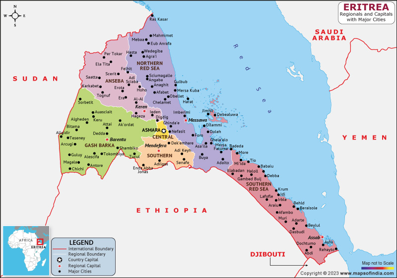
Eritrea is a tiny nation situated on the northeastern coast of the African continent, bordered by Ethiopia to the southern front, Sudan to the western front, and Djibouti to the southeastern front. It is a multi-ethnic country with a population of around 6 million people, and its capital and largest city is Asmara.
History:
Eritrea's history is rich and multifaceted, with traces of human presence extending far to the Paleolithic epoch. Many indigenous immigrant communities, including the Tigre, Bilen, Tigrinya, and Saho, have lived in the region throughout its history.
Eritrea was an Italian colony until the conclusion of the Second World War when it was put under British military control. The United Nations created Eritrea as an independent entity inside a confederation with Ethiopia in 1952. Yet, Ethiopia conquered Eritrea in 1962, igniting a decades-long violent battle for freedom.
Culture:
Eritrea has a rich and diverse culture that is influenced by its African, Arab, and European heritage. The country is home to several ethnic groups, each with its own unique cultural traditions.
Music is an important part of Eritrean culture, with traditional styles like tigrigna, tigre, and saho being popular. Eritrean cuisine is also diverse and flavorful, with dishes like injera (a type of flatbread), tsebhi (a spicy stew), and zigni (a spicy beef or lamb stew) being favorites.
Language:
The primary languages of the nations are Arabic, English, and Tigrinya. Tigrinya is the most widely spoken language in the country, with approximately 55% of the population speaking it as their first language. Arabic is also widely spoken, particularly in coastal areas, and English is used in official communication and education.
Geography:
Eritrea is a tiny nation situated on the northeastern coast of the African continent, bordered by Ethiopia to the southern front, Sudan to the western front, and Djibouti to the southeastern front. The country has a diverse landscape that includes the Red Sea coastline, the Danakil Depression (one of the hottest and driest places on Earth), and the highlands of the interior.
| Official Name | State of Eritrea |
| Capital | Asmara |
| Population | 3.6-6.7 Million |
| Area | 117,600 km2 |
| Currency | Nakfa |
| Religion | Christianity, Islam |
| Language | Tigrinya, Arabic, English |
| Major Cities | Keren, Teseney, Mendefera |
FAQs
Q1: What is the significance of Asmara's architecture?
Asmara, the capital city of Eritrea, is known for its unique and well-preserved Art Deco architecture. The buildings were constructed during the Italian colonial period and reflect a mix of Italian and Eritrean styles.
Q2: What is the coffee ceremony in Eritrea?
The coffee ceremony is a traditional ritual in Eritrea and other parts of the Horn of Africa. It involves roasting, grinding, and brewing coffee in a traditional clay pot called a jebena. The coffee is served to guests in small cups and is often accompanied by snacks like popcorn or roasted grains.
Q3: What is the significance of the Dahlak Archipelago?
The Dahlak Archipelago is a series of islands located northeast of Eritrea in the Red Sea. The islands are inhabited by an extensive variety of aquatic life, including whales, tortoises, and several fish species.
Q4: What is the traditional clothing of Eritrea?
Traditional clothing in Eritrea varies depending on the ethnic group, but generally includes loose-fitting garments made from lightweight materials like cotton or linen.
Last Updated on: April 17, 2023
